A photo map scheduling method and display system based on aerial photography

A technology of aerial photography and dispatching method, which is applied in the field of image processing, can solve the problems of inaccurate, untrue, and inconsistent with human visual experience, etc., and achieve better intuitive visual experience and avoid the effect of orthorectification

Active Publication Date: 2020-06-30
北京星球时空科技有限公司
View PDF5 Cites 0 Cited by
  • Summary
  • Abstract
  • Description
  • Claims
  • Application Information

AI Technical Summary

Problems solved by technology

[0005] In the prior art, since the original photo is a central projection and the orthographic image is an orthographic projection, when the original photo is orthorectified, the central projection is converted into an orthographic projection, but the display effect of the transformed image is inaccurate , Unreal, does not conform to the human visual experience

Method used


Image

  • A photo map scheduling method and display system based on aerial photography
  • A photo map scheduling method and display system based on aerial photography
  • A photo map scheduling method and display system based on aerial photography

Examples


Embodiment Construction

[0069] In order to make the purpose, technical solutions and advantages of the present invention clearer, the technical solutions in the embodiments of the present invention will be clearly and completely described below in conjunction with the accompanying drawings in the embodiments of the present invention. Obviously, the described embodiments are the Some, but not all, embodiments are invented. Based on the embodiments of the present invention, all other embodiments obtained by persons of ordinary skill in the art without creative efforts fall within the protection scope of the present invention.

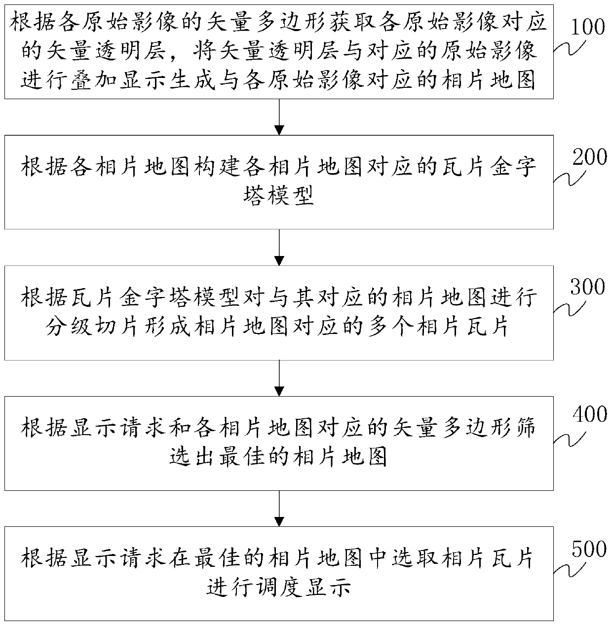
[0070] An exemplary embodiment of the present invention provides a photo-map scheduling method based on aerial photography, which can be implemented by a server and a terminal. A communication connection is established between the server and the terminal, and the server can process the original image of the aerial camera and provide map services according to the request of the t...


PUM


Abstract

The invention discloses a photomap scheduling method and display system based on aerial photography, and relates to the technical field of image processing. The method includes the following steps that according to the vector polygon of each original image, vector transparent layers corresponding to each original image are obtained, and each vector transparent layer and the corresponding originalimage are superimposed and displayed to generate a photomap corresponding to the corresponding original image; according to each photomap, a tile-pyramid model corresponding to each photomap is constructed; according to each tile-pyramid model, classification and segmentation are conducted on the photomap corresponding to the tile-pyramid model to form a plurality of photo tiles corresponding to the corresponding photomap; according to a display request and the vector polygon of each photomap, the optimal photomap is screened out; according to the display request, the photo tiles are selectedfrom the optimal photomap for scheduling display. The method and the system can more accurately and truthfully reflect ground object information, and the visual perception effect of the human body ismore excellent.

Description

technical field [0001] The invention relates to the technical field of image processing, in particular to a photo map scheduling method and display system based on aerial photography. Background technique [0002] The extensive application of the virtual globe combines geospatial information with thematic business information to build a service-oriented and open information platform. Today's mainstream virtual earth platforms include Google Earth, World Wind, pTolemy3D, etc. Most of them use the map tile library technology to form a positive pyramid data structure, and place the generated pyramid map tiles in the virtual directory of the server in advance. After receiving and verifying the client request, the server will return and display the pre-generated map tiles on different clients according to the geographical range and scale size requested by the client. [0003] Virtual earth platforms such as Google Earth, World Wind, and pTolemy3D all use orthoimages for display,...

Claims


Application Information

Patent Timeline
Patent Type & Authority Patents(China)
IPC IPC(8): G06F16/56G06F16/29
CPCG06F16/29G06F16/56
Inventor 韩嘉福罗斌黄淞杨阳
Owner 北京星球时空科技有限公司
Why Eureka
Try Eureka