Digital elevation model (DEM)-based topographic slope analysis method

An analysis method and slope technology, applied in 3D modeling, geographic information database, image data processing and other directions, can solve the problem of lack of terrain slope analysis methods and methods, and achieve the effect of accurate display form and accurate analysis method

Active Publication Date: 2018-03-23
THE 28TH RES INST OF CHINA ELECTRONICS TECH GROUP CORP
View PDF4 Cites 7 Cited by
  • Summary
  • Abstract
  • Description
  • Claims
  • Application Information

AI Technical Summary

Problems solved by technology

[0004] At present, when choosing a helicopter landing site, terrain elements mainly rely on map experience and naked eye observation during the mission process to make decisions. There is a lack of a fast and intuitive terrain slope analysis method and method based on digital maps in different modes, which can provide decision makers in mission execution. Before, provide an intuitive and effective task execution area and its surrounding terrain slope conditions, select the landing field in advance, and provide a reference for the rapid implementation of the task

Method used


Image

  • Digital elevation model (DEM)-based topographic slope analysis method
  • Digital elevation model (DEM)-based topographic slope analysis method
  • Digital elevation model (DEM)-based topographic slope analysis method

Examples


Embodiment

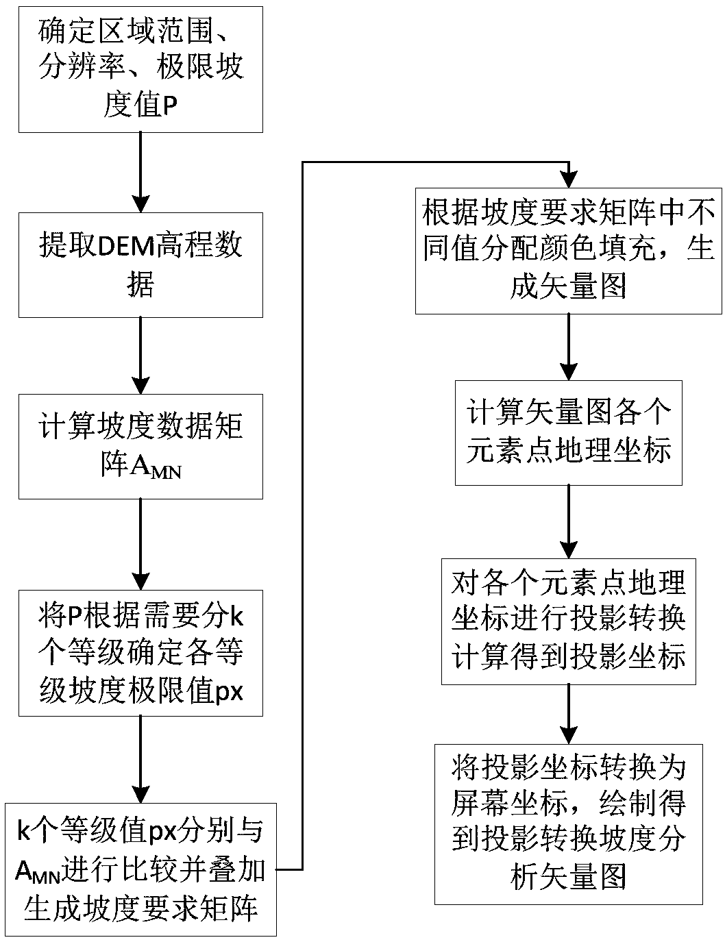
[0039] Take the landing site selection of a certain type of helicopter when performing a helicopter search and rescue mission near Ya'an area as an example. The application scenario is that four helicopters land in a single column in the target area. According to the quantitative formula of the landing site requirements, the landing site cannot be less than 423m×105m, and the maximum slope of the landing is selected according to the helicopter performance parameters P=5°. A suitable airfield is selected near the target area, so an area of ​​50 km around the target is selected for terrain slope analysis.

[0040] First, combined with the display resolution, the DEM elevation data is extracted with a resolution of 50m, and the slope matrix of the target area is calculated by using the slope algorithm

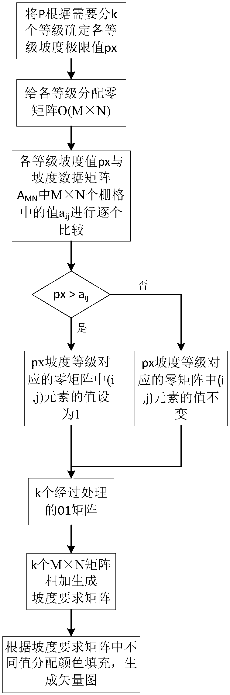
[0041] Divide the limit slope value P=5° required by the helicopter into three grades: ideal slope (0~2°), usable slope (2~5°), unusable slope (>5°), and ideal slope and availa...


PUM


Abstract

A DEM-based topographic slope analysis method disclosed by the present invention comprises the steps of combining different resolutions based on the DEM data, and calculating and extracting the slopedata of a raster matrix within a certain territorial scope; aiming at the concrete requirements of the topographic slope, dividing the grades of the slope requirements according to the rules, respectively comparing with the actual slope data matrixes to obtain a plurality of comparison result matrixes, fusing and superposing the comparison result matrixes to generate the slope requirement matrixes, and then distributing the colors according to the element values in the comparison result matrixes to fill, and generating a vector diagram; and finally adopting a projection algorithm to convert the vector diagram to obtain a slope analysis vector diagram satisfying a projection mode. The present invention provides a more visual and accurate topographic display form and analysis method for themilitary and civil fields having certain requirements for the topographic slope fluctuation, such as the helicopter landing, the search and rescue, the path planning, etc.

Description

technical field [0001] The invention relates to a topographic slope analysis method, in particular to a DEM-based topographic slope analysis method. Background technique [0002] Terrain slope analysis and rapid and accurate display have significant guiding and helpful significance in military and civil fields that have certain requirements for terrain undulations. For example, when carrying out helicopter search and rescue, the selection of the airfield is an important part of the search and rescue operation. The correct choice of the airfield can effectively take advantage of the helicopter's advantages and directly reach the disaster destination, which is of great significance to the completion of the search and rescue mission. The airfield should have One of the conditions is: close to the target of the scheduled search and rescue; the terrain is flat, and there are no obstacles that hinder the landing; there is enough area to facilitate aerial identification; therefore,...

Claims


Application Information

Patent Timeline
Patent Type & Authority Applications(China)
IPC IPC(8): G06T17/05G06F17/30
CPCG06F16/29G06T17/05
Inventor 吕海洋王鏖淯曾诚余思明杨雅迪宋钰涛
Owner THE 28TH RES INST OF CHINA ELECTRONICS TECH GROUP CORP
Why Eureka
Try Eureka