
Two-dimensional landform forward modeling and correcting method

A terrain and forward modeling technology, applied in geophysical survey, re-radiation of sound waves, measurement devices, etc., can solve problems such as terrain correction, inability to qualitative, semi-quantitative, quantitative judgment and interpretation, and inability to fundamentally solve problems, etc. , to avoid accidental errors

Inactive Publication Date: 2017-10-17
贵州省地质调查院
View PDF6 Cites 4 Cited by
  • Summary
  • Abstract
  • Description
  • Claims
  • Application Information

AI Technical Summary

Problems solved by technology

These practices are basically qualitative explanations and cannot fundamentally solve the problem
[0004] Later, some scholars used some analytical calculation methods to study the influence of terrain, and some inversion software also developed the terrain correction function, but based on the principle, the distortion correction of the abnormal shape according to the terrain is based on the distribution of the terrain to the static current, which is not true. Terrain correction does not make any changes to the magnitude of the resistivity value affected by the terrain, but only changes the shape of the anomaly, which does not achieve the purpose of real terrain correction in essence, and the results of the apparent resistivity anomaly obtained are not the objective existence of geological bodies. Rather, it cannot qualitatively, semi-quantitatively, or quantitatively judge and explain abnormalities

Method used


Image

  • Two-dimensional landform forward modeling and correcting method
  • Two-dimensional landform forward modeling and correcting method
  • Two-dimensional landform forward modeling and correcting method

Examples


Embodiment Construction

[0033] The technical solution of the present invention is further described below, but the scope of protection is not limited to the description.

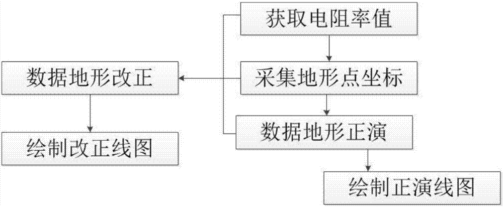
[0034] Such as figure 1 As shown, a two-dimensional terrain forward modeling and correction method, in drawing the apparent resistivity contour map, collects the coordinate point data of the terrain of the homogeneous medium and the terrain of the inhomogeneous medium and obtains its resistivity value, through positive Develop and correct to draw the apparent resistivity contour map of the pure terrain profile.

[0035] Based on a two-dimensional terrain forward modeling and correction method, it includes the following steps:

[0036] ① Obtain the resistivity value: take the average value of the apparent resistivity of the cross-section measured by the direct current method of any symmetrical quadrupole device and the same device by the high-density electric method as the apparent resistivity value of the topographical section of ...


PUM


Abstract

The invention provides a two-dimensional landform forward modeling and correcting method. During drawing of a apparent resistivity equivalent sectional drawing, coordinate point data acquisition of a homogeneous medium landform and coordinate point data acquisition of a heterogeneous medium landform are carried out to acquire resistivity values thereof, and an apparent resistivity equivalent sectional drawing of a pure landform section is drawn by forward modeling and correcting, The position, the form, and the number of the abnormal apparent resistivity of the landform section having uniform ups and downs are calculated correctly, and the false abnormity of the ups and downs of the landform formed in the section is displayed objectively, and then direct data operation is carried out, and therefore technical problems and troubles caused by production of conductive paper, resistive networks, water channels, and soil channels according to a certain proportion to simulate field conditions are eliminated, and at the same time, occasional errors caused by manual operation are eliminated.

Description

technical field [0001] The invention relates to a two-dimensional terrain forward modeling and correction method, belonging to the technical field of geographic information systems. Background technique [0002] "Arbitrarily symmetrical quadrupole devices for conventional direct current method (including the same device for high-density electric method)" are more and more widely used in mineral geology, hydrogeology, engineering geology and other fields. The interpretation of apparent resistivity data is in the horizontal (or monoclinic) in half space. However, there are various undulations in the actual terrain. Theory and practice show that the terrain can not only cause false anomalies, but also cover up the real anomalies caused by ore bodies or target geological bodies underground. If the data is processed and interpreted according to the horizontal (or monoclinic) terrain, it will inevitably cause certain errors, and even lead to completely wrong results. Misleading ...

Claims


Application Information

Patent Timeline
Patent Type & Authority Applications(China)
IPC IPC(8): G01V3/38
CPCG01V3/38
Inventor 敖怀欢汪玉琼李家斌张西君
Owner 贵州省地质调查院
Learn More