A Dem-Based Algorithm for Valley Cross-section Morphology

A cross-sectional and algorithmic technology, applied in the fields of cartography and geographic information systems, which can solve the problems of large data volume, low efficiency, and small research area.

Active Publication Date: 2020-09-18
GUANGXI TEACHERS EDUCATION UNIV
View PDF7 Cites 0 Cited by
  • Summary
  • Abstract
  • Description
  • Claims
  • Application Information

AI Technical Summary

Problems solved by technology

However, in previous studies, the research on rivers was mostly based on the extraction of parameters such as the cross-sectional area of ​​the water, the extraction of the water system, and the length of the water flow below the water area.
Especially for the study of the cross-section of the valley, it is necessary to intercept a large number of sections along the watershed, the amount of data is large, and the morphological characteristics are more complex than those of the longitudinal section
Researchers mostly obtain data through on-the-spot measurement or manual drawing based on topographic maps, which has a large workload, low efficiency, and a small research area, as well as a certain degree of subjectivity.

Method used


Image

  • A Dem-Based Algorithm for Valley Cross-section Morphology
  • A Dem-Based Algorithm for Valley Cross-section Morphology
  • A Dem-Based Algorithm for Valley Cross-section Morphology

Examples


Embodiment 1

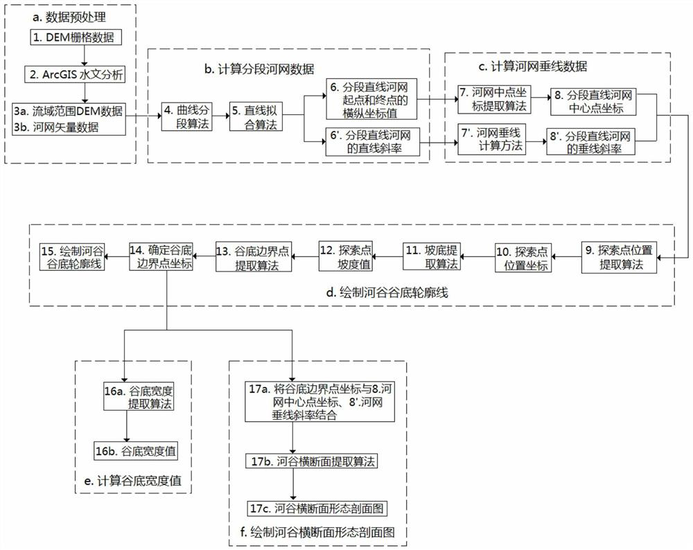
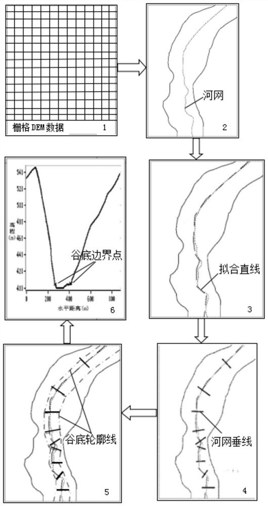
[0147] like figure 1 As shown, a DEM-based algorithm for the cross-sectional shape of the valley includes the following steps:

[0148] (a) DEM-based data preprocessing: based on DEM raster data, the hydrological analysis and processing function of ArcGIS software is used to complete the generation of non-depression DEM data, the analysis of water flow direction, the calculation of the accumulation of water flow, and the extraction of river networks Network and watershed segmentation to obtain watershed-wide DEM data and river network vector data;

[0149] (b) Calculation of segmented river network data: using the river network vector data obtained from the data preprocessing step (a) and the DEM data of the watershed range, the river network is first divided into N segments by the curve segmentation algorithm, and then the straight line fitting algorithm is used to divide the river network into N segments. The segmented curve river network is fitted into a straight segment ...

Embodiment 2

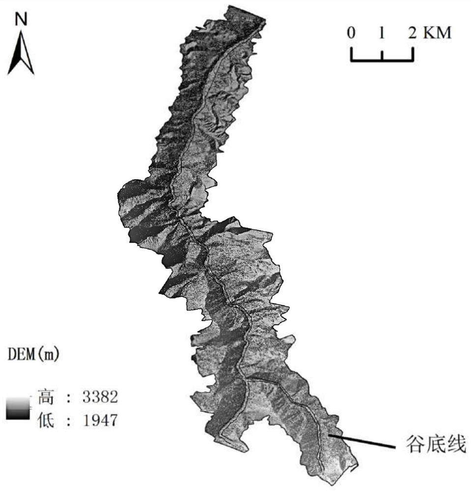
[0259] The middle section of the Russian River Valley selected in this example is a U-shaped river valley. Based on the DEM data of the middle section of the Russian River Valley, the optimal threshold is set as the fitting angle threshold ∠Al170°, the exploration distance threshold D is 4 meters, and the comparison slope threshold SlpThd is 25°, through the same steps as in Example 1, draw the valley bottom contour line of the middle reaches of the Russian River Valley, calculate the valley bottom width value and draw the valley cross-sectional profile.

[0260] The outline of the valley bottom of the middle reaches of the Russian River Valley is as follows Figure 7 shown.

[0261] When calculating the valley bottom width value, calculate the valley bottom width value of multiple position points at the same time and do a correlation analysis with the measured valley bottom width value, and obtain the correlation coefficient R between the calculated valley bottom width value ...


PUM


Abstract

The invention relates to the technical field of cartography and geography information systems, and specifically to a DEM-based river valley cross-section morphology algorithm. The algorithm includes the following six steps of (1) pre-processing data based on a DEM; (2) calculating sectional river network data; (3) calculating river network vertical data; (4) drawing a contour line of the valley bottom of a river valley; (5) calculating a width value of the valley bottom; and (6) drawing a profile map of the cross-section morphology of the river valley. The important quantitative indictors for describing the morphology of the river valley can be obtained by calculation according to the invention, which are the contour line of the valley bottom of the river valley, the width value of the valley bottom of the river valley and the profile map of the cross-section morphology of the river valley. These quantitative indicators can reveal the formation and development of a river, the construction situation of a valley landform and so on, and are of great theoretical significance for the study of the classification and management of rivers, the prediction of a river blocking probability of the landslide mass, the calculation of ground motion parameters and the like.

Description

technical field [0001] The invention relates to the technical field of cartography and geographic information systems, in particular to a DEM-based algorithm for the cross-sectional shape of a river valley. Background technique [0002] The study of river landforms is one of the core issues that hydrologists and geomorphologists at home and abroad pay attention to. However, in the previous studies, the study of rivers was mostly based on the extraction of parameters such as the cross-sectional area of ​​the water, the extraction of the water system, and the length of the water flow below the water area. Especially for the study of the cross section of the river valley, it is necessary to intercept a large number of sections along the watershed, the amount of data is large, and the morphological characteristics are more complex than the longitudinal section. Researchers mostly obtain data through field measurements or manual depiction based on topographic maps, which has a l...

Claims


Application Information

Patent Timeline
Patent Type & Authority Patents(China)
IPC IPC(8): G06T17/05
CPCG06T17/05
Inventor 赵银军武鹏飞李家旭
Owner GUANGXI TEACHERS EDUCATION UNIV
Why Eureka
Try Eureka