Satellite altimeter data-based sea level change trend calculation method and apparatus

A technology of changing trends and calculation methods, applied in the fields of calculation, electrical digital data processing, special data processing applications, etc., can solve problems such as being affected by crustal movement, and achieve the effect of accurate calculation results

Inactive Publication Date: 2017-09-01
NAT MARINE DATA & INFORMATION SERVICE
View PDF2 Cites 11 Cited by
  • Summary
  • Abstract
  • Description
  • Claims
  • Application Information

AI Technical Summary

Problems solved by technology

Although the tide gauge data have a long time series, they are only distributed in coastal areas and near...

Method used


Image

  • Satellite altimeter data-based sea level change trend calculation method and apparatus
  • Satellite altimeter data-based sea level change trend calculation method and apparatus
  • Satellite altimeter data-based sea level change trend calculation method and apparatus

Examples


Embodiment Construction

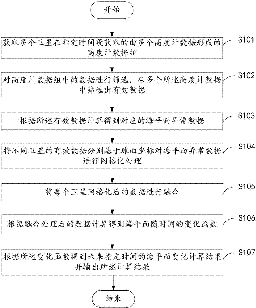
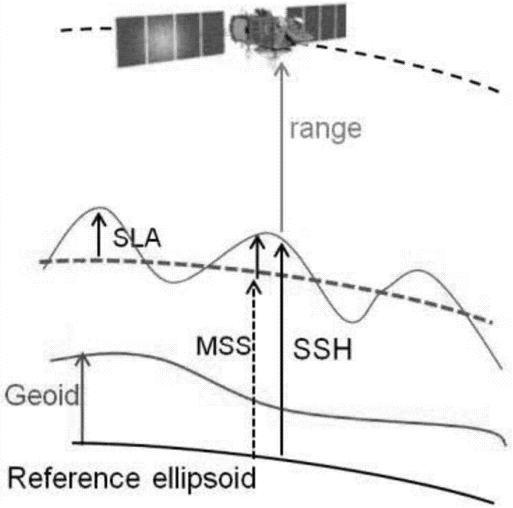
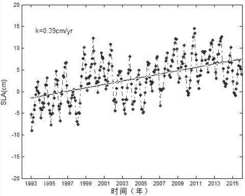
[0027] The following will clearly and completely describe the technical solutions in the embodiments of the present invention with reference to the accompanying drawings in the embodiments of the present invention. Obviously, the described embodiments are only some, not all, embodiments of the present invention. The components of the embodiments of the invention generally described and illustrated in the figures herein may be arranged and designed in a variety of different configurations. Accordingly, the following detailed description of the embodiments of the invention provided in the accompanying drawings is not intended to limit the scope of the claimed invention, but merely represents selected embodiments of the invention. Based on the embodiments of the present invention, all other embodiments obtained by those skilled in the art without making creative efforts belong to the protection scope of the present invention.

[0028] It should be noted that like numerals and let...


PUM


Abstract

Embodiments of the invention provide a satellite altimeter data-based sea level change trend calculation method and apparatus. The method comprises the steps of obtaining an altimeter data set formed by multiple pieces of altimeter data and obtained by multiple satellites in a specified time period; screening the data in the altimeter data set, and screening out effective data from the altimeter data, wherein the effective data includes sea level data; performing calculation according to the effective data to obtain corresponding abnormal sea level data; performing grid processing on the abnormal sea level data of different satellites based on spherical coordinates; fusing gridded data of the satellites; performing calculation according to the fused data to obtain a function of change, with time, of the sea level; and obtaining a calculation result of sea level change at a specified time in the future according to the change function and outputting the calculation result.

Description

technical field [0001] The invention relates to the field of marine environment monitoring, in particular to a method and device for calculating sea level change trends based on satellite altimeter data. Background technique [0002] The general sea level prediction method is to use tide gauge data. The sea level is measured by the tide gauge data based on the benchmark fixed on the land, and because the benchmark will rise and fall vertically with the crustal movement, the sea level measured by the tide gauge data is the relative sea level. Although the tide gauge data have a long time series, they are only distributed in coastal areas and near islands, and affected by crustal movement, the geographical distribution and accuracy have certain limitations. Contents of the invention [0003] In view of this, the purpose of the embodiments of the present invention is to provide a method and device for calculating sea level change trend based on satellite altimeter data. [...

Claims


Application Information

Patent Timeline
IPC IPC(8): G06F19/00
CPCG16Z99/00
Inventor 王慧李程李响李欢董军兴刘克修
Owner NAT MARINE DATA & INFORMATION SERVICE
Why Eureka
Try Eureka