
UAV heading calculation system and calculation method based on Beidou differential positioning

A differential positioning and unmanned aerial vehicle technology, applied in radio wave measurement systems, satellite radio beacon positioning systems, measurement devices, etc., can solve problems affecting the flight safety performance of unmanned aerial vehicles, scale factor heading errors, etc., to achieve low Heading error, the effect of ensuring flight safety

Active Publication Date: 2019-07-16
KUNMING UNIV OF SCI & TECH
View PDF4 Cites 0 Cited by
  • Summary
  • Abstract
  • Description
  • Claims
  • Application Information

AI Technical Summary

Problems solved by technology

However, in the process of determining the heading angle of the magnetic compass, the heading error occurs due to interference such as geomagnetic declination, soft / hard magnetic field deviation, scale factor error, three-axis magnetic field component coupling error, and quantization error, which in turn affects the flight of the UAV. safety performance

Method used


Image

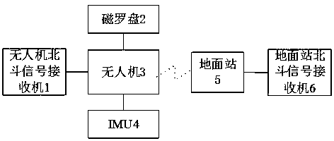
  • UAV heading calculation system and calculation method based on Beidou differential positioning
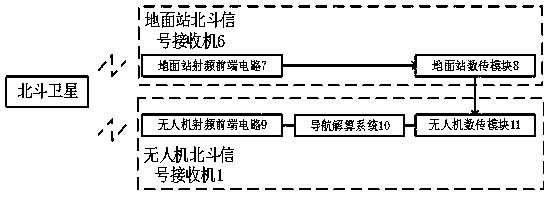
  • UAV heading calculation system and calculation method based on Beidou differential positioning
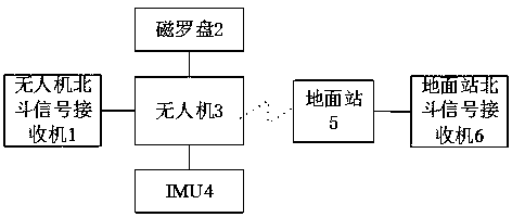
  • UAV heading calculation system and calculation method based on Beidou differential positioning

Examples


Embodiment 1

[0019] Embodiment 1: as Figure 1-2 As shown, a UAV heading calculation system based on Beidou differential positioning includes an UAV group and a ground station, and the UAV group includes a UAV 3, a magnetic compass 2 connected to the UAV, and an inertial measurement device 4 , UAV Beidou signal receiver 1, the magnetic compass 2 utilizes the inherent directivity of the geomagnetic field to measure the space attitude angle, and is used to measure the carrier heading, and the inertial measurement device 4 includes an acceleration sensor and an angular velocity sensor, and the acceleration sensor is used for Measure the acceleration component of the UAV 3 relative to the vertical line, the angular velocity sensor is used to measure the angle information of the UAV 3, and output the pitch angle and roll angle of the UAV 3 after fusion calculation; the UAV Beidou signal The receiver 1 is a Beidou radio frequency receiver, including an unmanned aerial vehicle radio frequency fro...


PUM


Abstract

The invention relates to a system and method for measuring and calculating a heading of an unmanned aerial vehicle based on Beidou differential positioning, belonging to the technical field of intelligent detection. The system comprises an unmanned aerial vehicle unit and a ground station, wherein the unmanned aerial vehicle unit comprises an unmanned aerial vehicle, a magnetic compass, an inertial measuring device and an unmanned aerial vehicle Beidou signal receiver, wherein the ground station comprises a ground Beidou signal receiver; and the inertial measuring device comprises an accelerated speed sensor and an angular speed sensor. According to the system for measuring and calculating the heading of the unmanned aerial vehicle based on the Beidou differential positioning, by utilizing a carrier phase difference technique, a three-dimensional positioning result of the unmanned aerial vehicle in an appointed coordinate system can be provided in real time, centimeter-level precision is realized, even when the magnetic compass is interfered and the heading cannot be accurately acquired, the high-precision measurement and calculation of the heading of the unmanned aerial vehicle in a high-speed flight state can be still realized, and the flight heading can be corrected, so that the safe flight of the unmanned aerial vehicle is guaranteed.

Description

technical field [0001] The invention relates to an unmanned aerial vehicle course measuring and calculating system based on Beidou differential positioning and a measuring and calculating method thereof, belonging to the technical field of intelligent detection. Background technique [0002] At present, the magnetic compass is widely used in the calculation of the heading angle of small rotor UAVs, because it has the advantages of low cost, fast dynamic response, short startup time, small size, and low power consumption. However, in the process of determining the heading angle of the magnetic compass, the heading error occurs due to interference such as geomagnetic declination, soft / hard magnetic field deviation, scale factor error, three-axis magnetic field component coupling error, and quantization error, which in turn affects the flight of the UAV. safety performance. Contents of the invention [0003] The technical problem to be solved by the present invention is to p...

Claims


Application Information

Patent Timeline
Patent Type & Authority Patents(China)
IPC IPC(8): G01S19/41G01S19/43
CPCG01S19/41G01S19/43
Inventor 范玉刚李越孙磊吴建德王晓东黄国勇邹金慧冯早
Owner KUNMING UNIV OF SCI & TECH
Learn More