
Method and system for forecasting comprehensive water levels of sea areas in real time

A realization method and water level technology, applied in the direction of engine lubrication, liquid/fluid solid measurement, instruments, etc., can solve problems such as isolation, failure to meet the needs of comprehensive water level prediction in coastal waters, and single prediction elements

Inactive Publication Date: 2017-05-17
NAT MARINE DATA & INFORMATION SERVICE
View PDF7 Cites 4 Cited by
  • Summary
  • Abstract
  • Description
  • Claims
  • Application Information

AI Technical Summary

Problems solved by technology

[0004] To sum up, the existing forecasting methods mainly have single and isolated forecasting elements, and the tidal tide level and storm tide level are forecasted separately, and the interaction between the two is not considered, and the comprehensiveness of the forecast results is not high. High, the influencing factors considered in the forecast are not comprehensive enough, and the influence of ocean currents is not included, which cannot meet the needs of comprehensive water level prediction in coastal waters, and affects the efficiency and accuracy of comprehensive water level real-time forecasting, and there are certain limitations

Method used


Image

  • Method and system for forecasting comprehensive water levels of sea areas in real time
  • Method and system for forecasting comprehensive water levels of sea areas in real time
  • Method and system for forecasting comprehensive water levels of sea areas in real time

Examples


Embodiment 1

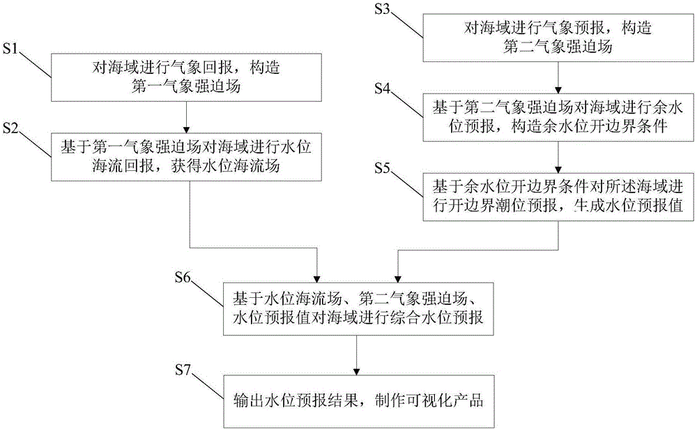
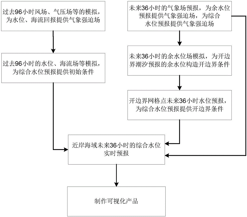
[0070] Such as figure 1 and figure 2 As shown, the embodiment of the present invention provides a method for realizing real-time forecasting of comprehensive water level in sea areas, which is used for real-time forecasting of comprehensive water level in near-shore sea areas, including the following steps:

[0071] S1: Make meteorological reports on the sea area and construct the first meteorological forcing field;

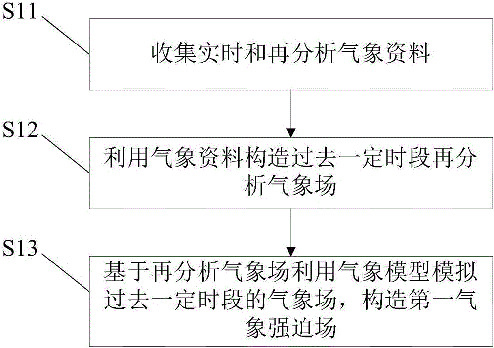
[0072] Specifically, refer to image 3 , including the following sub-steps:

[0073] S11: Collect real-time and reanalyzed meteorological data;

[0074] Meteorological data include typhoon track, central air pressure, central wind speed, temperature, air pressure, humidity, wind speed, wind direction, etc. when extratropical cyclones occur

[0075] S12: Use meteorological data to construct a certain period of time in the past and then analyze the meteorological field;

[0076] Meteorological data are used to construct reanalyzed meteorological fields for a ...

Embodiment 2

[0138] Such as Figure 9 As shown, the embodiment of the present invention provides a system for realizing real-time comprehensive water level forecasting in sea areas, which includes a meteorological reporting module 1, a water level ocean current reporting module 2, a weather forecasting module 3, a remaining water level forecasting module 4, an open boundary tide level forecasting module 5 and Integrated Water Level Forecasting Module6.

[0139] Meteorological report module 1 is used to report the weather to the sea area and construct the first meteorological forcing field, which specifically includes the following aspects:

[0140] Collect real-time and reanalyzed meteorological data;

[0141] Using meteorological data to construct a certain period of time in the past and then analyze the meteorological field;

[0142] Based on the reanalysis of the meteorological field, the meteorological model is used to simulate the meteorological field for a certain period of time in...


PUM


Abstract

The invention provides a method and a system for forecasting comprehensive water levels of sea areas in real time, and belongs to the field of marine environment forecasting. The method includes reporting back the meteorology for the sea areas and constructing first meteorological force fields; reporting back water level sea current on the basis of the first meteorological force fields and acquiring water level sea current fields; forecasting the meteorology for the sea areas and constructing second meteorological force fields; forecasting residual water levels on the basis of the second meteorological force fields and constructing residual water level open boundary conditions; forecasting open boundary tide levels on the basis of the residual water level open boundary conditions and generating water level forecast values; forecasting the comprehensive water levels of the sea areas on the basis of the water level sea current fields, the second meteorological force fields and the water level forecast values. The method and the system have the advantages that the comprehensive water levels of the offshore sea areas can be forecast in real time, and the comprehensive water level real-time forecasting efficiency and precision can be improved.

Description

technical field [0001] The invention relates to the technical field of marine environment forecasting, in particular to a method and system for realizing real-time forecasting of comprehensive water levels in coastal sea areas. Background technique [0002] The water level changes in the coastal waters will directly affect the coastal areas, especially under extreme weather conditions such as typhoons and extratropical cyclones, the high water levels will cause serious disasters in coastal areas. The comprehensive water level includes not only the normal change of ocean water level dominated by tidal action under normal weather conditions, but also the change of storm surge water level under extreme weather conditions. According to the requirements of the national and local people's governments at all levels for marine forecasting work, realizing real-time prediction and early warning of comprehensive water levels in coastal waters will effectively improve the disaster preve...

Claims


Application Information

Patent Timeline
IPC IPC(8): G01F23/00
CPCG01F23/80
Inventor 高志刚张建立武双全张增健高通王慧陈满春刘克修
Owner NAT MARINE DATA & INFORMATION SERVICE
Learn More