
A precise positioning system for unmanned aerial vehicles

A technology of precise positioning and positioning system, applied in satellite radio beacon positioning system, radio wave measurement system, measuring device, etc., can solve the problems that are difficult to improve the efficiency and quality of inspection work

Active Publication Date: 2017-10-10
PUYANG POWER SUPPLY COMPANY STATE GRID HENAN ELECTRIC POWER +1
View PDF4 Cites 0 Cited by
  • Summary
  • Abstract
  • Description
  • Claims
  • Application Information

AI Technical Summary

Problems solved by technology

Therefore, it will be difficult to improve the efficiency and quality of inspection work

Method used


Image

  • A precise positioning system for unmanned aerial vehicles
  • A precise positioning system for unmanned aerial vehicles
  • A precise positioning system for unmanned aerial vehicles

Examples


Embodiment Construction

[0033] The present invention will be further described in detail by means of drawings and embodiments below.

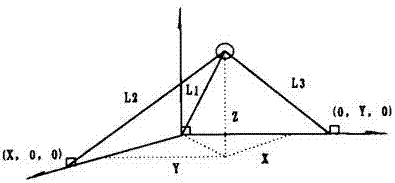
[0034] A UAV precise positioning system, such as figure 1 As shown, it includes a flight control system, a GPS positioning system and an ultrasonic positioning system. The flight control system is connected with the infrared receiver, the GPS positioning system, and the ultrasonic positioning system respectively, and the infrared receiver is connected with the remote controller.

[0035] The ultrasonic positioning system includes a controller and a radio frequency transceiver module, such as figure 2 shown. The radio frequency transceiver module includes an ultrasonic receiver, an ultrasonic transmitter, an address coding transmitting circuit, a non-address coding trigger circuit, a radio frequency receiving circuit and a radio frequency transmitting circuit. The controller is an AT89S51 single-chip controller, and the controller is connected with the flight contro...


PUM


Abstract

The invention discloses a precise positioning system for an unmanned aerial vehicle, comprising a flight control system, a GPS positioning system and an ultrasonic positioning system. The flight control system is respectively connected with an infrared receiver, a GPS positioning system and an ultrasonic positioning system. Connect with the remote control. Before reaching the area requiring precise landing, the GPS positioning system guides the flight control system according to manual remote control; when reaching the area requiring precise landing, the ultrasonic positioning system is automatically turned on, and signals are continuously transmitted between the ultrasonic receiver and the ultrasonic transmitter. , the flight control system continuously measures the distance between them, the flight control system updates the target position, and adjusts the flight attitude at any time. Therefore, the GPS positioning system of the present invention realizes basic positioning, the ultrasonic positioning system realizes precise positioning, and the UAV can be accurately positioned through the GPS positioning system and the ultrasonic positioning system, so that the UAV can be accurately dropped into a specific area.

Description

technical field [0001] The invention relates to the technical field of drone positioning, in particular to a system for precise positioning of drones based on GPS and ultrasonic technology. Background technique [0002] With the development of the domestic economy, the scale of the power grid has gradually expanded, and the long-distance high-voltage transmission lines have grown rapidly. Many high-voltage lines cross mountains, rivers and rivers. Traditional manual line inspection is affected by factors such as terrain and environment, and is inefficient, time-consuming, and inaccurate inspection data. [0003] Therefore, in recent years, China has gradually developed UAV smart inspection technology, which is not affected by the geographical environment and greatly improves work efficiency. At the same time, the unmanned aerial vehicle has a unique line of sight inspection, uses advanced airborne inspection equipment, collects image and video data, and can observe transmis...

Claims


Application Information

Patent Timeline
Patent Type & Authority Patents(China)
IPC IPC(8): G01S19/45
CPCG01S19/45
Inventor 王胜丹杨进学孟凡众张亚博胡永辉何惠松
Owner PUYANG POWER SUPPLY COMPANY STATE GRID HENAN ELECTRIC POWER
Learn More