
A UAV flight path planning method for intelligent identification of threat types

A technology for path planning and drones, applied in three-dimensional position/channel control, etc., can solve problems such as unpredictable drone threats

Active Publication Date: 2017-05-24
华北计算技术研究所
View PDF2 Cites 0 Cited by
  • Summary
  • Abstract
  • Description
  • Claims
  • Application Information

AI Technical Summary

Problems solved by technology

Unknown threats, on the contrary, cannot predict threats that will appear while the drone is in flight

Method used


Image

  • A UAV flight path planning method for intelligent identification of threat types
  • A UAV flight path planning method for intelligent identification of threat types
  • A UAV flight path planning method for intelligent identification of threat types

Examples


Embodiment Construction

[0062] The present invention will be described in detail below with reference to the accompanying drawings and examples.

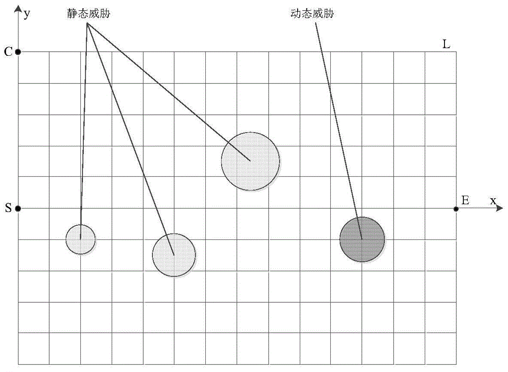
[0063] Rasterize the search area: An analysis of threats including mountains, electromagnetics, and radars reveals that most of the areas they cover are approximately circular areas with the threat source as the center and the threat range as the radius. Therefore, in the process of modeling the threat area in this paper, the threat area is regarded as a circle. In addition, the grid method is currently the most widely studied space path calculation method, which divides the searchable flight space of UAVs into multiple simple areas, called grids.

[0064] Based on the two-dimensional description of the entire space, the search area is divided by the grid method. In practice, considering that the current average speed of the UAV is Mach 4.3 (about 1430m / s), the adjacent grids are set The length of grid nodes is 1500m. Such as figure 1 As shown, its spec...


PUM


Abstract

The invention discloses a flying path planning method of unmanned plane capable of intelligently identifying threat types. The unmanned plane flying path planning method can intelligently identify threat types and search the best flying path under mixed environment. The method comprises a detection period and an operation period. The detection period is that a plurality of detection bodies conduct detection together to complete the basic cognition of the search area. The method mainly comprises the steps of node information value update, dynamic threat identification, and static threat avoidance, and the forming of basic optimization route. The operation period is that a single unmanned plane completes practical path searching. By means of the basic cognition formed at the detection period, the static threat can be accurately prevented in a practical executing period, the dynamic threat can be identified at an early stage, and the optimized route can be planned rapidly. Accordingly, the unmanned plane can arrive at destination safely and rapidly.

Description

technical field [0001] The invention relates to the field of threat identification in mixed environments and real-time calculation of flight paths, in particular to a flight path planning method for intelligently identifying threat types. Background technique [0002] UAVs need to pass through a certain physical area when performing flight missions, and attack or reconnaissance targets in the area. The UAV needs to find the optimal flight path to ensure that it can reach the target point safely from the starting point. In the process, the UAV needs to avoid the enemy's defense forces in the area and the obstacles of the natural environment, so that the UAV can reach the destination safely. land. [0003] The pre-set area is the space for the UAV to plan the route, but there are generally threats such as natural terrain, weather, electromagnetic interference, and enemy air defense and anti-aircraft artillery. The sources and forms of threats are diverse, and threats are ana...

Claims


Application Information

Patent Timeline
Patent Type & Authority Patents(China)
IPC IPC(8): G05D1/10
Inventor 杜雁双王磊刘春生费林鹤
Owner 华北计算技术研究所
Learn More