A Xijiang waterway navigation monitoring system based on Beidou satellite

A Beidou satellite and monitoring system technology, applied in traffic control systems, ship traffic control, instruments, etc., can solve problems such as low-precision positioning services, GPS system safety hazards, etc., and achieve the effects of visual command, easy implementation, and low cost

Active Publication Date: 2016-08-17
柳州市欧博科技有限公司
View PDF5 Cites 0 Cited by
  • Summary
  • Abstract
  • Description
  • Claims
  • Application Information

AI Technical Summary

Problems solved by technology

The current monitoring system mainly uses the Global Positioning System (GPS system) developed by the United States, but the GPS system has many security risks. For example, GPS only provides high-precision positioning for the United States (especially the US military), and only for users in other countries. Provides low-accuracy location services that the US can turn off at any time (especially in wartime)

Method used


Image

  • A Xijiang waterway navigation monitoring system based on Beidou satellite

Examples


Embodiment Construction

[0021] The principles and features of the present invention are described below in conjunction with the accompanying drawings, and the examples given are only used to explain the present invention, and are not intended to limit the scope of the present invention.

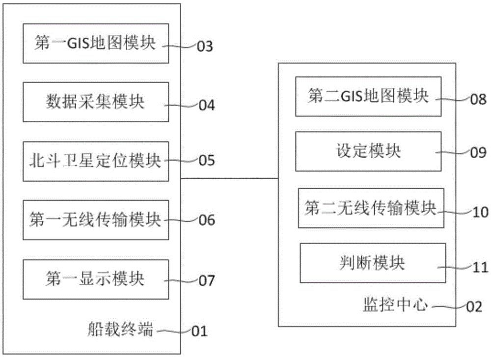
[0022] Such as figure 1 As shown, it is a structural schematic diagram of a Xijiang waterway navigation monitoring system based on Beidou satellite, including a shipboard terminal 01 and a monitoring center 02. The shipboard terminal 01 is installed on a transport ship to obtain all The position data of the transport ship, and the position data and the travel information of the transport ship are sent to the monitoring center 02; the monitoring center 02 is used to receive a plurality of transport ship position data and travel information , judging whether there is a ship in a dangerous driving state, sending an alarm signal to the transport ship in the dangerous driving state, and / or sending the position data and d...


PUM


Abstract

The invention relates to a Xijiang waterway shipping monitoring system based on the Beidou satellite. The system comprises a shipborne terminal and a monitoring center, wherein the shipborne terminal is installed on a transport ship so as to be used for obtaining the position data of the transport ship by the Beidou satellite system and sending the position data and the travelling information of the transport ship to the monitoring center to be used to judge whether a ship is in a dangerous travelling state according to the received position data and the travelling information of a plurality of transport ships, and sending an alarm signal to the transport ship in the dangerous state, and / or sending the position data and the travelling information of the other transport ships in the neighbouring water areas to the transport ships. The Xijiang waterway shipping monitoring system has the characteristics of low cost, easiness in implementation, stability in operation, and the like. Users can efficiently and visually command, schedule and monitor ships in real time.

Description

technical field [0001] The invention relates to a shipping monitoring system, in particular to a Xijiang waterway shipping monitoring system based on Beidou satellites. Background technique [0002] The Xijiang River is an important water transportation artery connecting Guangxi and Yunnan and Guizhou with Guangdong, Hong Kong and Macao regions. Ensuring the smooth and safe water transportation channel is an important basis for the Pearl River inland waterway transportation to provide high-quality, efficient and competitive services. In order to ensure the Xijiang shipping The safety of the ship, especially during the Spring Festival travel season, when the traffic is heavy and the business is busy, it is urgent to understand the various conditions of the ship in real time, so as to ensure the safe operation of the ship. The current monitoring system mainly uses the Global Positioning System (GPS system) developed by the United States, but the GPS system has many security ri...

Claims


Application Information

Patent Timeline
Patent Type & Authority Patents(China)
IPC IPC(8): G08G3/00
Inventor 张增芳张媛张竞
Owner 柳州市欧博科技有限公司
Why Eureka
Try Eureka