Eureka AIR delivers breakthrough ideas for toughest innovation challenges, trusted by R&D personnel around the world.

Spatial neighborhood information weighted hyper-spectral remote sensing image classification method

A technology of hyperspectral remote sensing and neighborhood information, which is applied in the field of hyperspectral remote sensing image classification weighted by spatial neighborhood information, can solve the problems of large data volume and redundancy of hyperspectral remote sensing images, reduce redundancy, improve efficiency, The effect of eliminating noise

Active Publication Date: 2013-12-11
CHONGQING UNIV OF POSTS & TELECOMM
View PDF2 Cites 26 Cited by
  • Summary
  • Abstract
  • Description
  • Claims
  • Application Information

AI Technical Summary

Problems solved by technology

[0009] The technical problem to be solved by the present invention is to propose a spatial neighborhood information weighted high Spectral Remote Sensing Image Classification Method

Method used


Image

  • Spatial neighborhood information weighted hyper-spectral remote sensing image classification method
  • Spatial neighborhood information weighted hyper-spectral remote sensing image classification method
  • Spatial neighborhood information weighted hyper-spectral remote sensing image classification method

Examples


Embodiment Construction

[0018] The classification method based on feature space is a hot research direction in recent years, which can be divided into unsupervised classification method and supervised classification method. Fuzzy C-means clustering (FCM) is an objective function method proposed by Bezdek, which is a classic unsupervised classification algorithm and the most famous and widely used algorithm among fuzzy clustering algorithms. The FCM algorithm is a flexible fuzzy division, which can overcome the shortcomings of the hard division of the ordinary C-means algorithm to a certain extent. The basic idea is to maximize the similarity between objects classified into the same cluster, and minimize the similarity between different clusters.

[0019] The meanings of the variables mainly involved in this paper are as follows: IM represents the 3-dimensional hyperspectral image data matrix; B represents the 2-dimensional data matrix corresponding to IM; S represents the sample matrix of part of the...


PUM


Abstract

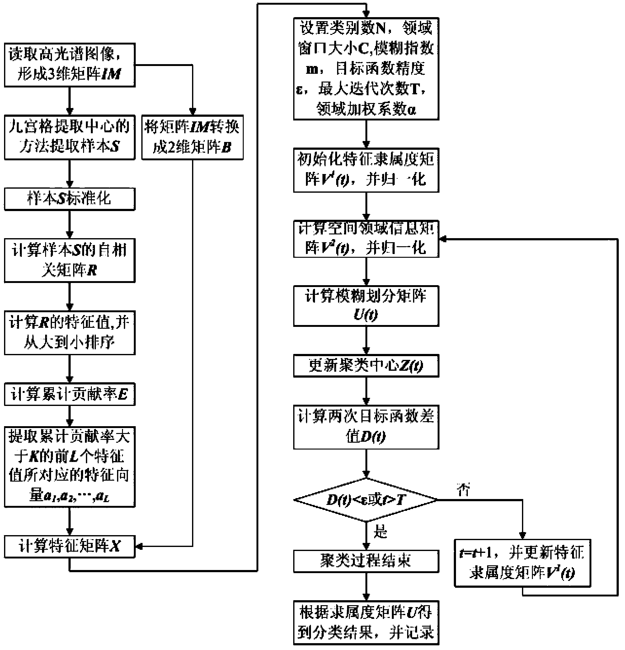
The invention discloses a spatial neighborhood information weighted hyper-spectral remote sensing image classification scheme aiming at a problem that noising exists in an image classification result existing in the conventional hyper-spectral remote sensing image classification technology. The scheme comprises the following steps: performing partial principal component analysis on preprocessed image data to acquire a converted characteristic matrix; performing quick clustering on the characteristic matrix by using a spatial neighborhood information weighted FCM (Fuzzy C-Means) algorithm to obtain a classification result of a hyper-spectral image. According to the hyper-spectral remote sensing image classification scheme, the effect of principal component analysis feature dimension reduction and the rich spatial neighborhood information on the hyper-spectral image are fully combined; the classification result of the hyper-spectral image is improved while the efficiency of the algorithm is guaranteed; compared with the conventional method, the scheme has the advantages that the amount of calculation can be reduced, the classification result can be improved, the phenomenon of noising caused by a same object with different spectrums and noise can be overcome and an excellent classification result can be obtained.

Description

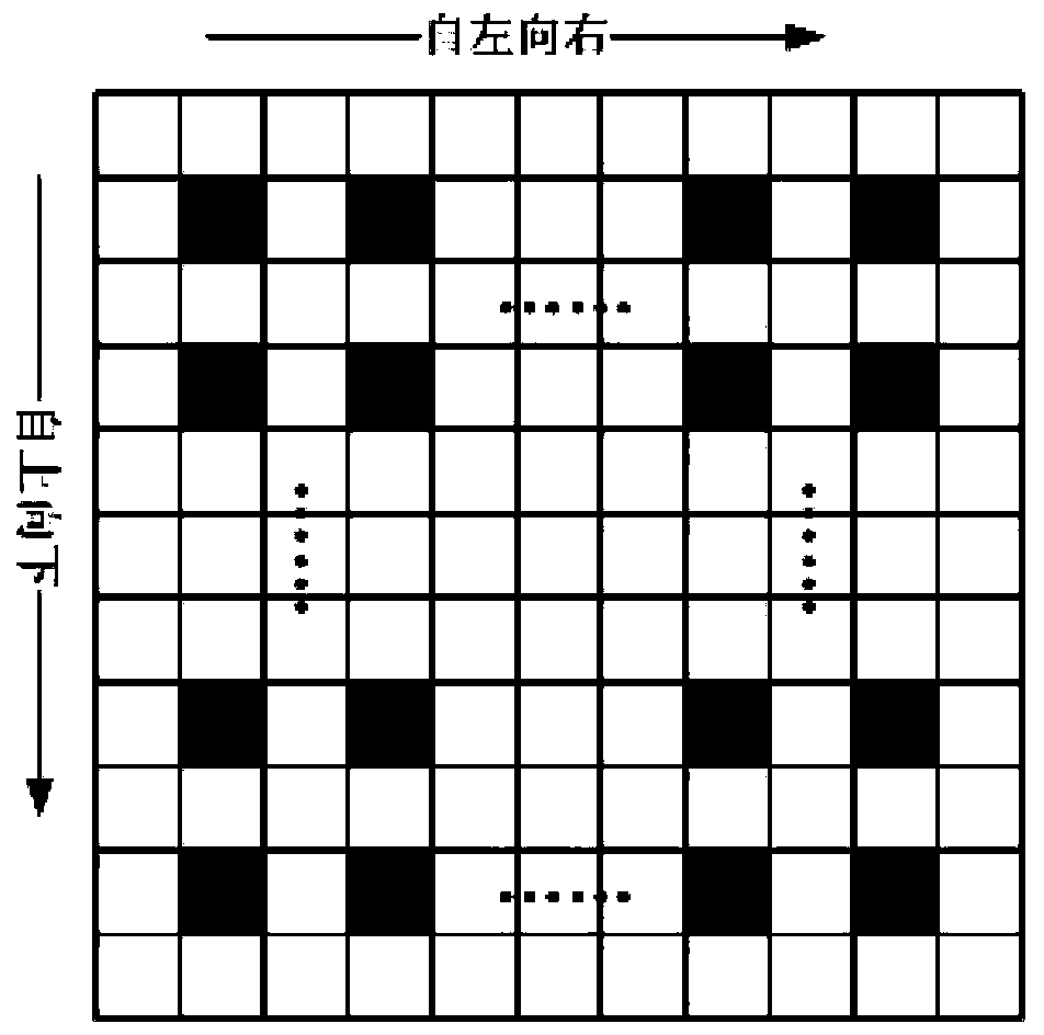
[0001] technology neighborhood [0002] The invention belongs to the field of hyperspectral remote sensing image processing, and in particular relates to a hyperspectral remote sensing image classification method weighted by spatial neighborhood information. Background technique [0003] Hyperspectral remote sensing technology is an emerging remote sensing technology. It combines imaging technology and subdivision spectrum technology revolutionaryly with the help of imaging spectrometer. Compared with traditional multi-spectral remote sensing, hyperspectral remote sensing has high spectral resolution and map integration , The advantage of continuous imaging in a certain spectral range. These characteristics and advantages make hyperspectral images widely used in many fields such as the detection of military targets, the fine classification of vegetation, the identification of geological rocks and minerals, marine detection, environmental detection, and urban planning. Hypersp...

Claims


Application Information

Patent Timeline
Patent Type & Authority Applications(China)
IPC IPC(8): G06K9/62
Inventor 陈善学李俊于佳佳韩勇冯银波
Owner CHONGQING UNIV OF POSTS & TELECOMM
Why Eureka
Eureka Blog
Learn More