A Geographic Virtual Simulation 3D Mouse Pen in Real Space

A real space, three-dimensional mouse technology, applied in the fields of GIS technology, wireless communication, and GPS technology, can solve the problems of increasing immersion, inability to realize geographical virtual simulation scene reproduction operation, and intuition, and achieve the goal of enhancing interactivity and immersion Effect

Active Publication Date: 2016-03-02
GUILIN UNIVERSITY OF TECHNOLOGY
View PDF7 Cites 0 Cited by
  • Summary
  • Abstract
  • Description
  • Claims
  • Application Information

AI Technical Summary

Problems solved by technology

[0002] The research on 3D terrain modeling and its visualization is one of the most dynamic directions in the field of geoscience information technology. In recent years, the research on geographic virtual simulation technology has been extensive at home and abroad. Among them, the human-computer interaction function of the operating system is the most A very important part of the geographic virtual simulation system is also an important factor that determines the operability of the geographic virtual simulation system. Especially in recent years, the development of real space 3D visualization technology enables users to integrate into the geographic virtual simulation system personally. Increased user immersion; however, most of the existing 3D visualization systems mainly use traditional interactive methods such as keyboards, mice, and various pattern recognition devices, which are cumbersome and unintuitive to operate, and cannot realize geographic virtual simulation scenes in real space reproduction operations; for example, when the object being processed is a traditional two-dimensional model, the two-dimensional movement of the interactive device (mouse) cursor can be mapped to the two-dimensional model one by one, so that almost all required operations can be realized conveniently; however, When in the geographic virtual simulation system of real space, the object of concern during interaction becomes a three-dimensional geographic model, because the image point (x, y) on the computer screen is different from the three-dimensional coordinates (x, y, z) of the real space. Having a unique corresponding relationship greatly increases the difficulty of the interactive operation, and the traditional interactive method can no longer satisfy the reproduction operation of the geographic virtual simulation scene in the real space

Method used


Image

  • A Geographic Virtual Simulation 3D Mouse Pen in Real Space
  • A Geographic Virtual Simulation 3D Mouse Pen in Real Space
  • A Geographic Virtual Simulation 3D Mouse Pen in Real Space

Examples


Embodiment

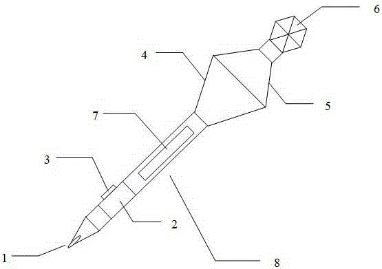
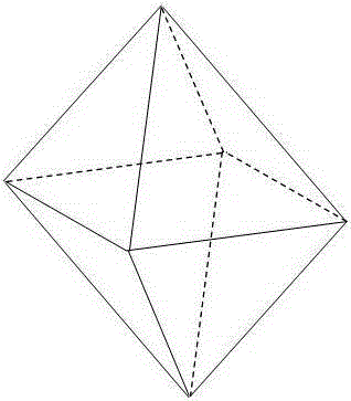
[0028] like figure 1 As shown, the three-dimensional mouse pen is composed of a nib part, a pen holder part 8, a device part and a prism body 6; 2 connected power supply module 7 and control button 3; the device part near the end is provided with a tilt sensor 4 and a wireless transceiver device 5; the end is a prism body 6, and its human-computer interaction method is that the user interacts with the user through visual and command button interaction channels. The geographic virtual system of the real space communicates to achieve the purpose of human-computer interaction.

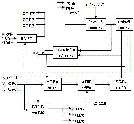
[0029] The tilt sensor 4 of the device part adopts a strapdown tilt sensor, which is composed of a three-axis vibrating gyroscope, a three-axis servo accelerometer, a magnetic orientation sensor and a host end, and an orientation program and a tilt angle measurement program are provided inside; the tilt sensor 4 Based on the output signals of gyroscopes, accelerometers, and azimuth sensors, using comput...


PUM


Abstract

The invention discloses a geographic virtual simulation three-dimensional mouse pen in real space. It consists of a nib part, a pen barrel part, a device part and a prism body. The pen tip part is composed of an LED light pen tip connected with the control button; the pen barrel part is equipped with a control unit, a power module connected with the control unit and control buttons; the device part near the end is equipped with a tilt sensor and a wireless transceiver device; the end is a The prism body, its human-computer interaction method is that the user communicates with the geographic virtual system in the real space through the visual and command button interaction channels, so as to achieve the purpose of human-computer interaction. The present invention uses the three-dimensional mouse pen in the geographic virtual simulation system of the real space, enabling users to interact with the geographic virtual environment in a more real, more intuitive and more effective manner, greatly enhancing the interactivity and immersion, and providing users with a A human-computer interaction method that is more general and directly manipulates geographic virtual environment scenes in real space.

Description

technical field [0001] The invention belongs to the field of GPS technology, GIS technology and wireless communication technology, in particular to a geographical virtual simulation human-computer interaction method in real space based on GPS and GIS technology and wireless communication technology, which realizes the geographical virtual simulation system between users and real space A device for human-computer interaction. Background technique [0002] The research on 3D terrain modeling and its visualization is one of the most dynamic directions in the field of geoscience information technology. In recent years, the research on geographic virtual simulation technology has been extensive at home and abroad. Among them, the human-computer interaction function of the operating system is the most A very important part of the geographic virtual simulation system is also an important factor that determines the operability of the geographic virtual simulation system. Especially ...

Claims


Application Information

Patent Timeline
Patent Type & Authority Patents(China)
IPC IPC(8): G06F3/0346
Inventor 李景文张源唐诗华陆妍玲
Owner GUILIN UNIVERSITY OF TECHNOLOGY
Why Eureka
Try Eureka