Application of ARCVIEW GIS (geographic information system) 3.2 technology in mountainous land building design

A kind of architectural design and mountain technology, applied in the field of mountain architectural design based on ARCVIEW GIS 3.2 platform, can solve the problems of lack of qualitative and quantitative analysis

Inactive Publication Date: 2012-09-26
黄丹丹
View PDF1 Cites 17 Cited by
  • Summary
  • Abstract
  • Description
  • Claims
  • Application Information

AI Technical Summary

Problems solved by technology

[0003] In order to improve the systematic and scientific nature of traditional mountain building design and solve the lack of qualitative and quantitative an...

Method used


Image

  • Application of ARCVIEW GIS (geographic information system) 3.2 technology in mountainous land building design

Examples


Embodiment Construction

[0015] The present invention is done concrete embodiment analysis below:

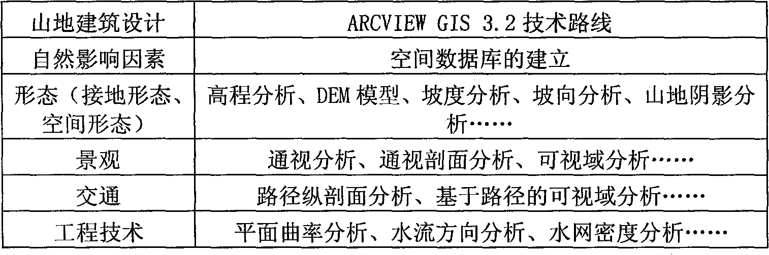
[0016] Step 1, data collection. Including various natural factors affecting mountain architecture: geology, topography, climate, hydrology, vegetation. At present, the most important basis or data source for establishing urban spatial terrain database is map. It represents the water system, terrain, soil quality, vegetation, settlements, transportation network, boundary line and other natural geographical elements and general characteristics of social and human elements on the earth's surface.

[0017] Step 2, establishment of spatial database. For the digital collection and graphic output of the topographic map, the 1:500 vector topographic map of Zhangping Dongshan Park was selected in August 2004, and AUTOCAD2007 was used to establish the digital elevation data space model and other existing buildings, river water bodies, vegetation conditions, road traffic, etc. The special vector data model uses...


PUM


Abstract

The invention relates to a design method of a mountain land building, in particular relates to a mountainous land building design method based on an ARCVIEW GIS (geographic information system) 3.2 platform. At present, common methods for mountainous land building design are hand drawing, CAD (computer-aided design) drawing, 3DMAX, SU (sketch up), manual model research and the like, and the design methods tend to two-dimensional and static research. The mountainous land building design method based on the ARCVIEW GIS 3.2 technology, which is provided by the invention, comprises the following steps of: 1, collecting data; 2, creating a spatial database; 3, building a digital elevation model (DEM); 4, carrying out morphological analysis; 5, carrying out landscape analysis; 6, carrying out traffic analysis; and 7, carrying out engineering technology analysis. The method is a quantitative and qualitative scientific analysis method for mountainous land building design, and spatial analysis, three-dimensional analysis and image analysis functions and data management ability of the method can be applied to research on multiple aspects of mountainous land building design, thus the design method disclosed by the invention has a considerable prospect.

Description

technical field [0001] The invention relates to a design method of mountain buildings, in particular to a design method of mountain buildings based on the ARCVIEW GIS 3.2 platform. Background technique [0002] Compared with traditional mountain architectural design methods, ARCVIEW GIS 3.2 can help people obtain complex and systematic mountain information, and establish a dynamic development system of the past, present and future prediction of mountain elements through analysis and mathematical simulation. In particular, ARCVIEW GIS 3.2 technology's powerful spatial analysis, three-dimensional analysis and image analysis functions and data management capabilities can be applied to many aspects of mountain architectural design research. Combined with architectural design, such as the analysis of slope, aspect, elevation, mountain shading, and visibility of mountains, it will help architects get closer to the essence of architecture and make correct decisions. Contents of t...

Claims


Application Information

Patent Timeline
IPC IPC(8): G06F17/50
Inventor 黄丹丹
Owner 黄丹丹
Why Eureka
Try Eureka