SINS (strap-down inertia navigation system)/SMANS (scene matching auxiliary navigation system)/TRNS (terrain reference navigation system) combined navigation method based on federated filtering and system
An integrated navigation system and federated filtering technology, applied in the direction of integrated navigators, etc., can solve the problems of expensive inertial system and limited accuracy improvement, and achieve high fault tolerance, improved accuracy, and high reliability
- Summary
- Abstract
- Description
- Claims
- Application Information
AI Technical Summary
Problems solved by technology
Method used
Image
Examples
Embodiment 1
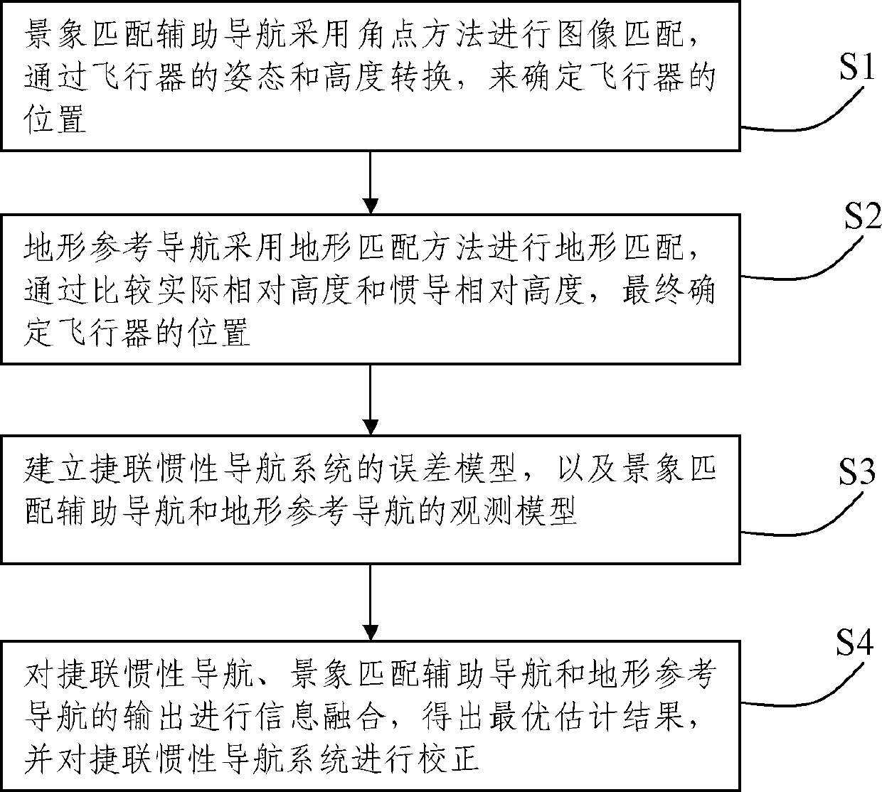
[0067] Such as figure 1 As shown, the present embodiment describes a federated filtering-based SINS / SMANS / TRNS integrated navigation method, comprising the following steps:
[0068] S1: Scene matching aided navigation uses the corner point method for image matching, and determines the position of the aircraft through the attitude and height conversion of the aircraft;
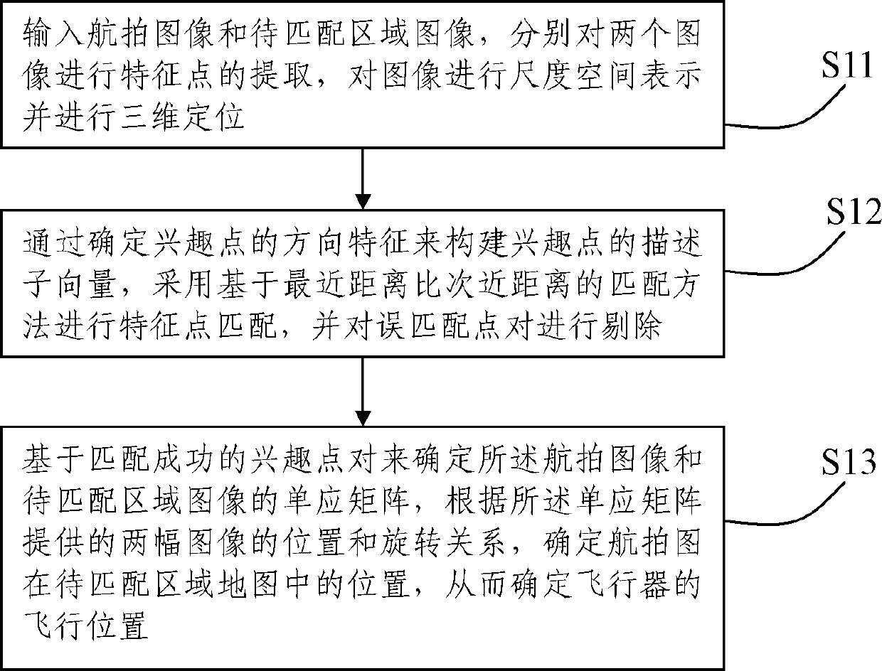
[0069] Such as figure 2 As shown, the step S1 specifically includes the following steps:
[0070] S11: Input the aerial image and the image of the area to be matched, respectively extract the feature points of the two images using the method of approximating the Hessian matrix with a frame filter, represent the image in scale space and perform three-dimensional positioning;
[0071] S12: Construct the descriptor vector of the point of interest by determining the direction feature of the point of interest, use the matching method based on the closest distance ratio to perform feature point matching, and use t...
Embodiment 2
[0129] Such as Figure 6 As shown, this embodiment records an integrated navigation system for implementing the above integrated navigation method, including:
[0130] Atmospheric inertial navigation system, used to obtain and output inertial navigation position information;
[0131] The flight track generator module is used to simulate the flight track of the aircraft to obtain the position, speed and attitude information of the aircraft;
[0132] SINS / SMANS integrated navigation system, including:
[0133] Image sensor viewing area and positioning parameter calculation module, used to calculate the viewing area and positioning parameters of the onboard image sensor according to the position information output by the atmospheric inertial navigation system;
[0134] A digital reference map database, used to obtain a suitable digital reference map according to the calculation results of the image sensor viewing area and the positioning parameter calculation module;
[0135] ...
PUM
 Abstract
Description
Claims
Application Information
 - R&D
- Intellectual Property
- Life Sciences
- Materials
- Tech Scout
- Unparalleled Data Quality
- Higher Quality Content
- 60% Fewer Hallucinations
Browse by: Latest US Patents, China's latest patents, Technical Efficacy Thesaurus, Application Domain, Technology Topic, Popular Technical Reports.
© 2025 PatSnap. All rights reserved.Legal|Privacy policy|Modern Slavery Act Transparency Statement|Sitemap|About US| Contact US: help@patsnap.com


