
Coal mine disaster relief robot navigation system and method based on information fusion

A navigation system and robot technology, applied in navigation, surveying and mapping and navigation, navigation computing tools, etc., to achieve the effects of light weight, enhanced reliability, and improved convergence

Inactive Publication Date: 2011-12-21
CHINA UNIV OF MINING & TECH (BEIJING)
View PDF5 Cites 25 Cited by
  • Summary
  • Abstract
  • Description
  • Claims
  • Application Information

AI Technical Summary

Problems solved by technology

Compared with previous navigation systems and methods, the present invention adopts ultrasonic navigation, visual navigation and inertial navigation to design a multi-sensor fusion navigation system and method suitable for coal mine disaster relief robots, and proposes an improved neural network-extended Kalman filter method (NNEKF: Neural network Extended Kalman Filter), this algorithm can effectively solve the problem of information fusion mismatch, improve the convergence and real-time performance of the system, and reduce the error

Method used


Image

  • Coal mine disaster relief robot navigation system and method based on information fusion
  • Coal mine disaster relief robot navigation system and method based on information fusion
  • Coal mine disaster relief robot navigation system and method based on information fusion

Examples


Embodiment Construction

[0047] The following implementation examples will further illustrate the present invention, and implementation examples should not be considered as limiting the scope of the present invention. The working mode of the present invention will be described in detail below in conjunction with the accompanying drawings and implementation examples.

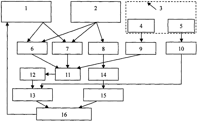
[0048] Such as figure 1 Shown is a structural block diagram of a multi-sensor fusion navigation system and method for a coal mine disaster relief robot.

[0049] The ultrasonic module 1 uses the time difference between the transmitted wave and the received wave to measure the distance.

[0050] The measurement formula is: Among them, d is the distance between the robot and the measured obstacle, C is the propagation speed of the sound wave in the medium, and T is the time difference between the transmitted wave and the received wave.

[0051] Three pairs of ultrasonic transducers are used, which are respectively placed in the front, ...


PUM


Abstract

The invention discloses a coal mine disaster relief robot navigation system based on information integration and a method. An ultrasonic wave module 1, a vision module 2 and an inertia module 3 form an information acquisition module, the information acquired by the information acquisition module is processed by an information processing module, so that the path planning is realized; and the improved neural network-extended Kalman filter (NNEFK) method is provided, and the method can effectively solve the problem that the information integration is not matched, improves the convergence and thereal-time property, and reduces the errors of the navigation system and the method by the design of a feedback link. The navigation system and the method can effectively improve the navigation capability of a coal mine disaster relief robot.

Description

technical field [0001] The invention relates to a robot navigation system and method, in particular to a navigation system and method using multi-sensor information fusion technology applied to coal mine disaster relief robots. Background technique [0002] my country is a big country of coal production and consumption. In my country's energy industry, coal accounts for about 70% of my country's primary energy production and consumption structure. According to the forecast of the National Energy Work Conference, by the end of the "Twelfth Five-Year Plan", my country's total coal consumption will exceed 4 billion tons, of which domestic production will exceed 3.8 billion tons, and my country's coal production will account for 50% of the global total. The continuous increase of coal production, coupled with the poor natural conditions of coal mines, relatively backward technology and lack of management, have resulted in frequent mine disasters and accidents, with heavy casualt...

Claims


Application Information

Patent Timeline
IPC IPC(8): G01C21/20G01C21/00G06N3/02
Inventor 田子建张立亚
Owner CHINA UNIV OF MINING & TECH (BEIJING)
Learn More