
A positioning method and device

A technology for location information and base station positioning, applied in electrical components, wireless communication and other directions, can solve problems such as affecting the accuracy of wireless positioning

Inactive Publication Date: 2011-12-14
BEIJING UNIV OF POSTS & TELECOMM
View PDF5 Cites 31 Cited by
  • Summary
  • Abstract
  • Description
  • Claims
  • Application Information

AI Technical Summary

Problems solved by technology

[0005] The current wireless positioning method based on the cellular network has serious non-linear propagation conditions such as reflection, diffraction, and diffraction in the cellular network environment, so it will be affected by NLOS (Non-Line-Of-Sight, non-line-of-sight propagation) Effect, multipath effect, system measurement error, CDMA (Code Division Multiple Access, Code Division Multiple Access) multiple access interference and other factors affect the accuracy of wireless positioning

Method used


Image

  • A positioning method and device
  • A positioning method and device
  • A positioning method and device

Examples


Embodiment 1

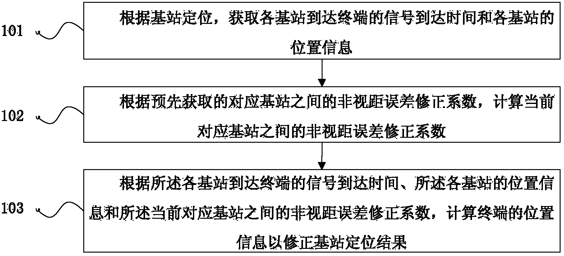
[0066] Embodiment 1 of the present invention proposes a positioning method, the process of which is as follows figure 1 shown, including:

[0067] Step 101: According to the positioning of the base station, the signal arrival time of each base station arriving at the terminal and the location information of each base station are obtained;

[0068] Step 102: Calculate the current non-line-of-sight error correction coefficient between corresponding base stations according to the pre-acquired non-line-of-sight error correction coefficient between corresponding base stations;

[0069] Step 103: Calculate the location information of the terminal to correct the base station positioning result according to the arrival time of signals from the base stations to the terminal, the location information of the base stations, and the non-line-of-sight error correction coefficient between the current corresponding base stations.

[0070] In the embodiment of the present invention, the base ...

Embodiment 2

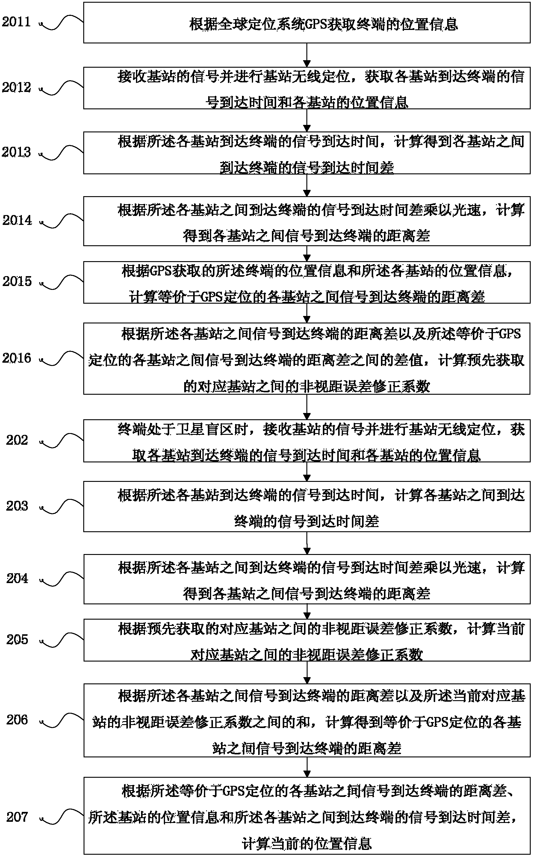
[0072] Embodiment 2 of the present invention proposes a positioning method, the process of which is as follows figure 2 shown, including:

[0073] Step 201: The non-line-of-sight error correction coefficient between corresponding base stations acquired in advance by the terminal.

[0074] Specifically:

[0075] Step 2011: Obtain the location information of the terminal according to the global positioning system GPS.

[0076] When the positioning terminal can receive effective satellite signals, the satellite signal is received by the positioning terminal, the pseudo-range from the positioning terminal to the satellite is measured, and data such as satellite orbit parameters are demodulated. Calculate the longitude, latitude, altitude and other information of the user's geographic location through positioning calculation.

[0077] Step 2012: Receive the signal of the base station and perform wireless positioning of the base station, and obtain the arrival time of the signal...

Embodiment 3

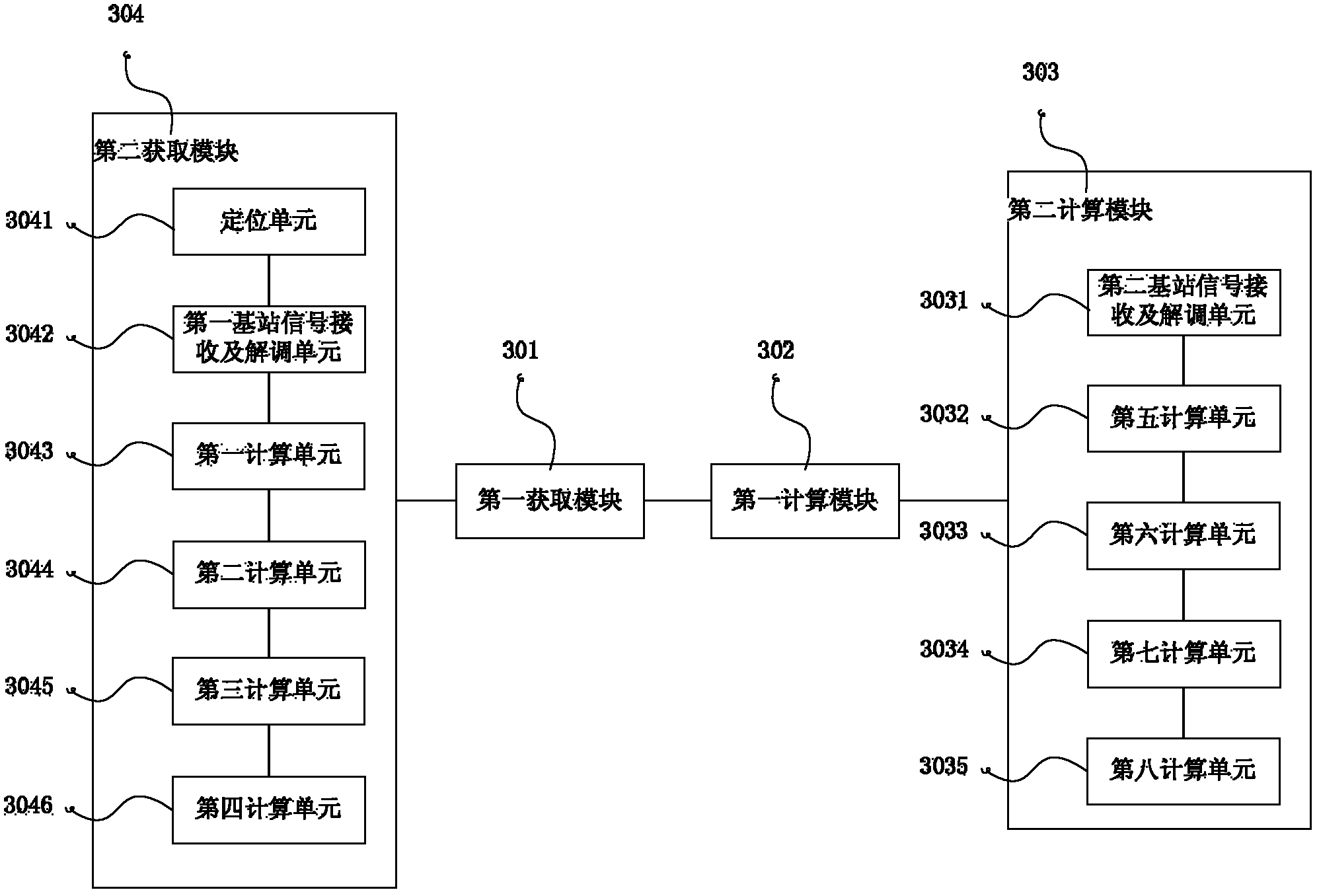
[0131] Embodiment 3 of the present invention proposes a positioning device, the structure of which is as follows image 3 shown, including:

[0132] The first acquisition module 301 is configured to acquire the arrival time of signals from each base station to the terminal and the location information of each base station according to the positioning of the base stations.

[0133] The first calculation module 302 is configured to calculate a non-line-of-sight error correction coefficient between corresponding base stations currently based on a pre-acquired non-line-of-sight error correction coefficient between corresponding base stations.

[0134] Wherein, the first calculation module 302 is specifically used for:

[0135] According to the base station positioning non-line-of-sight error correction coefficient acquired in advance, the current non-line-of-sight error correction coefficient between corresponding base stations is calculated by Kalman filtering.

[0136] The sec...


PUM


Abstract

The embodiment of the invention discloses a positioning method and device, belonging to the field of positioning. The method includes: according to the positioning of the base stations, obtaining the signal arrival time of each base station arriving at the terminal and the position information of each base station; Distance error correction coefficient: calculate the position information of the terminal to correct the base station positioning result according to the arrival time of the signals from the base stations to the terminal, the position information of the base stations, and the non-line-of-sight error correction coefficient between the current corresponding base stations . In the embodiment of the present invention, the base station positioning error in the satellite blind area is calculated by a seamless positioning method of the satellite blind area of ​​the fusion satellite and the base station. This makes it possible to obtain higher-precision terminal location information only through base station positioning when satellite signals cannot be received, avoiding positioning in a cellular network environment and the situation of low positioning accuracy caused by various interference factors.

Description

technical field [0001] The invention relates to the field of positioning, in particular to a positioning method and device. Background technique [0002] In recent years, with the continuous improvement of people's material living standards, people's demand for location-based services is also increasing day by day. Users can use client software installed on mobile terminals (such as mobile phones, etc.) The actual geographic location of the site, thereby providing location-related service information. [0003] At present, GPS (Global Positioning System, Global Positioning System) technology is commonly used for positioning. However, there are certain blind spots in GPS positioning. When the user needs to provide positioning services indoors or in an environment that does not meet the GPS positioning conditions, after the GPS radio frequency signal penetrates the wall of the building, the signal strength becomes very weak, and the positioning effect is not ideal. . Therefo...

Claims


Application Information

Patent Timeline
Patent Type & Authority Applications(China)
IPC IPC(8): H04W64/00
Inventor 邓中亮余彦培邓耀宇吕子平施浒立来奇峰那日苏
Owner BEIJING UNIV OF POSTS & TELECOMM
Learn More