Method for performing remote-sensing monitoring on soil moisture content

A soil moisture content, remote sensing monitoring technology, applied in the field of environmental remote sensing, can solve the problems of soil moisture improvement accuracy limit, etc., to achieve the effect of high accuracy

Inactive Publication Date: 2013-08-14
王桥
View PDF1 Cites 0 Cited by
  • Summary
  • Abstract
  • Description
  • Claims
  • Application Information

AI Technical Summary

Problems solved by technology

However, due to the influence of soil surface roughness, texture, etc., this method is limited in improving the accuracy of soil moisture monitoring.

Method used


Image

  • Method for performing remote-sensing monitoring on soil moisture content
  • Method for performing remote-sensing monitoring on soil moisture content
  • Method for performing remote-sensing monitoring on soil moisture content

Examples


Embodiment Construction

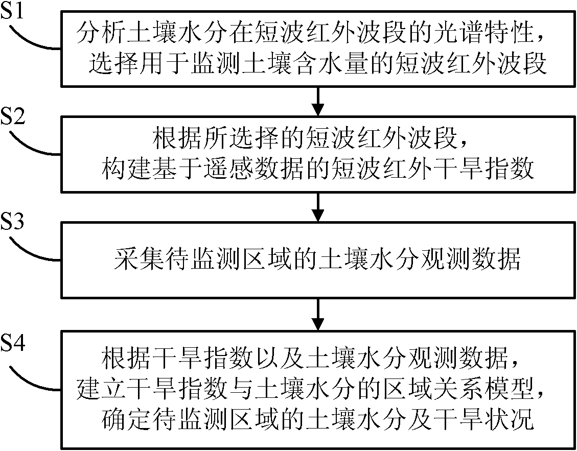
[0028] The soil water content remote sensing monitoring method proposed by the present invention is described in detail as follows in conjunction with the accompanying drawings and examples.

[0029] The Earth Observation System (EOS) series satellites are used to conduct atmospheric physical and chemical observations and land, hydrology, climate, and environmental surveys using satellite remote sensing technology, to obtain various comprehensive information on natural environmental resources more accurately, and to grasp the overall status of the earth's environmental resources and Its changing trend, the most important instrument on it is Moderate-resolution Imaging Spectroradiometer (MODIS, Moderate-resolution Imaging Spectroradiometer), its maximum spatial resolution can reach 250 meters, and the scanning width is 2330 kilometers. MODIS is a new generation of "map-integrated" optical remote sensing instrument in the world. It has 36 discrete spectral bands, including near-i...


PUM


Abstract

The invention discloses a method for performing remote-sensing monitoring on soil moisture content. The method comprises the following steps of: S1, analyzing the spectral characteristic of soil moisture in a short wave infrared band, and selecting the short wave infrared band which is used for monitoring the soil moisture; S2, constructing a short wave infrared drought index based on remote sensing date according to the selected short wave infrared band; S3, acquiring the observation data of the soil moisture in an area to be monitored; and S4,establishing an area relationship model of the drought index and the soil moisture according to the drought index and the observation data of the soil moisture, and determining the soil moisture and the drought condition of the area to be monitored. By the method, the soil moisture / drought condition of the area can be estimated quickly and effectively so as to guide the agricultural production, water resources planning and the like, and the accuracy is high.

Description

technical field [0001] The invention relates to the technical field of environmental remote sensing, in particular to a soil moisture remote sensing monitoring method. Background technique [0002] Soil moisture at the spatial scale is a key variable for the development of agricultural production, quantitative monitoring of regional resources and the environment, and has important application value in ecological environments such as agriculture, hydrology, and meteorology. Traditional classic soil moisture measurement methods such as soil drying method, neutron moisture meter method and tensiometer method have high accuracy, but the sampling speed is slow, requires a lot of manpower and material resources, and is mostly limited to the range of point measurement, which is difficult To meet the application requirements of large-area monitoring of soil moisture in actual production, the development of remote sensing technology with the characteristics of large-scale and rapid o...

Claims


Application Information

Patent Timeline
Patent Type & Authority Patents(China)
IPC IPC(8): G01N21/27
Inventor 王桥赵少华张峰刘思含李营吴艳婷
Owner 王桥
Why Eureka
Try Eureka