
Routing method based on bandwidth and delay bi-objective optimization

A dual-target, routing technology, applied in electrical components, wireless communication, network topology, etc., can solve problems such as inability to meet bandwidth and real-time performance

Active Publication Date: 2011-11-09
江苏创想视界物联网科技有限公司
View PDF2 Cites 25 Cited by
  • Summary
  • Abstract
  • Description
  • Claims
  • Application Information

AI Technical Summary

Problems solved by technology

[0006] The above satellite routing method only considers a single factor such as the minimum delay, the minimum number of hops or the best link bandwidth utilization
It cannot meet the bandwidth and real-time requirements in the propagation process

Method used


Image

  • Routing method based on bandwidth and delay bi-objective optimization
  • Routing method based on bandwidth and delay bi-objective optimization
  • Routing method based on bandwidth and delay bi-objective optimization

Examples


Embodiment Construction

[0025] The principles and features of the present invention are described below in conjunction with the accompanying drawings, and the examples given are only used to explain the present invention, and are not intended to limit the scope of the present invention.

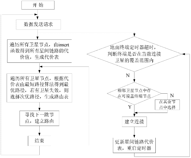
[0026] figure 1 Shown is the spherical coordinate system of the satellite in the Satellite Integrated Information Network. The center of the system is the center of the earth, the Z axis is consistent with the earth's rotation axis, (R, θ, Ф) = (6378km, 90°, 0°) corresponds to the 0° meridian (prime meridian) of the earth's equator, according to each satellite Geographical location (that is, longitude and latitude), the distance between the stars can be calculated. figure 2 Shown is the BDSR routing algorithm flow, according to figure 1 Calculate the inter-satellite distance, calculate the weight COST value of the inter-satellite link and generate a cost table; combine the shortest path algorithm to generate a ro...


PUM


Abstract

The invention relates to a routing method based on bandwidth and delay bi-objective optimization. The method comprises the following steps that: a source node sends a request to send; a cost table is initialized; if a timer is judged to be overtime, the cost table is updated and the timer is restarted; a routing table is generated according to the shortest path algorithm; and a current node seeks the next-hop node according to the routing table to establish a complete route. The method has the following beneficial effects: the bandwidth and the delay can be well balanced; and the link with larger residual bandwidth is selected under the condition of heavy link bandwidth load, thus greatly improving the average minimum bandwidth of the path under the condition of limited change of the average end to end delay of the path.

Description

technical field [0001] The invention relates to a routing method based on dual-objective optimization of bandwidth and time delay. A routing algorithm that comprehensively considers two indicators of bandwidth and time delay on an inter-satellite link is adopted. The performance of each item is adjusted at the same time, so that the system performance presents a good change trend, and belongs to the technical field of mobile Ad hoc network routing. Background technique [0002] The satellite integrated information network is an intelligent system composed of various types of satellites in different orbits, interconnected and organically formed according to the principle of maximally effective and comprehensive utilization of space information resources. Satellite networks not only provide global coverage with continuous high-bandwidth performance, but also support flexible and scalable network configurations. The transmission of voice, data and multimedia applications throu...

Claims


Application Information

Patent Timeline
IPC IPC(8): H04W40/02H04W84/06
Inventor 张登银刘莎殷曼莉邹志强刘林峰程春玲
Owner 江苏创想视界物联网科技有限公司
Learn More