
Method for remotely sensing and quantitatively monitoring steppe vegetation coverage space-time dynamic change

A technology of vegetation coverage and spatiotemporal dynamics, applied in the direction of complex mathematical operations, can solve problems such as the lack of monitoring of grassland vegetation coverage spatiotemporal dynamic change indicators, the inability to comprehensively, deeply and quantitatively support the research on the dynamic change characteristics of grassland vegetation, and the lack of systematicness, etc. question

Inactive Publication Date: 2011-09-14
SATELLITE ENVIRONMENT CENT MINIST OF ENVIRONMENTAL PROTECTION
View PDF2 Cites 13 Cited by
  • Summary
  • Abstract
  • Description
  • Claims
  • Application Information

AI Technical Summary

Problems solved by technology

[0004] At present, the domestic use of vegetation NDVI data to monitor the temporal and spatial dynamic changes of grassland vegetation coverage mainly analyzes the change of NDVI average value, but has not established a quantitative evaluation method for multiple indicators. Research in this area is still limited and cannot comprehensively, deeply and quantitatively support grassland vegetation dynamics. Research on the characteristics of change; while there are few foreign countries that have carried out monitoring of the dynamic change indicators of grassland vegetation cover in time and space, the research is not systematic and has not been well applied

Method used


Image

  • Method for remotely sensing and quantitatively monitoring steppe vegetation coverage space-time dynamic change
  • Method for remotely sensing and quantitatively monitoring steppe vegetation coverage space-time dynamic change
  • Method for remotely sensing and quantitatively monitoring steppe vegetation coverage space-time dynamic change

Examples


Embodiment Construction

[0051] In order to make the purpose, content, and advantages of the present invention clearer, the specific implementation manners of the present invention will be further described in detail below in conjunction with the accompanying drawings and embodiments.

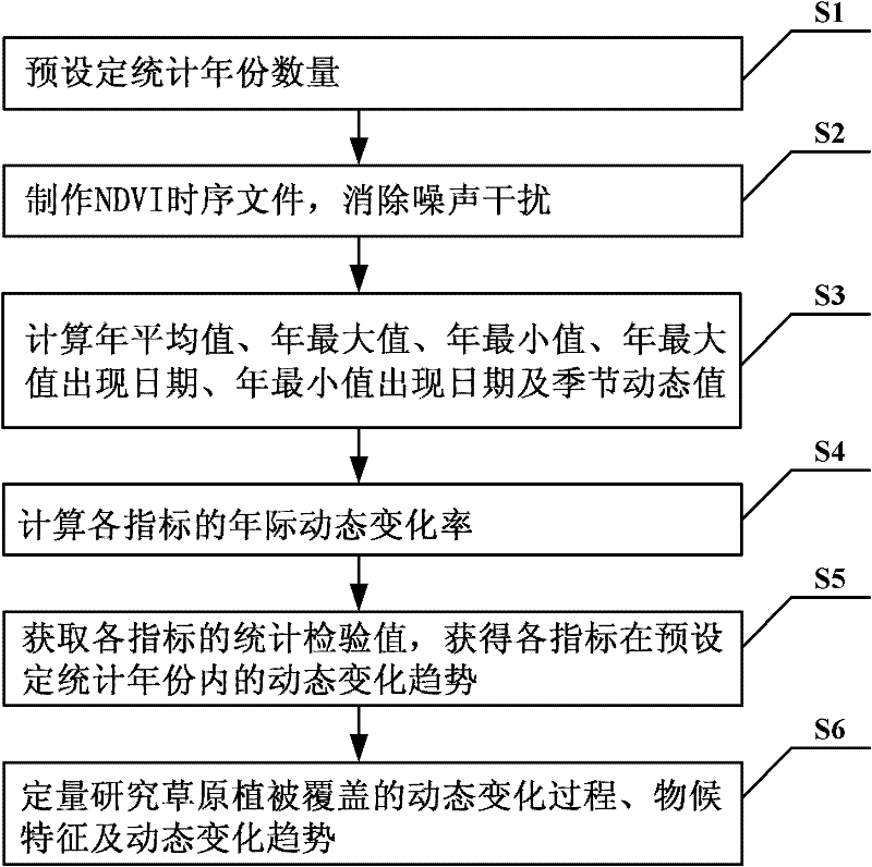
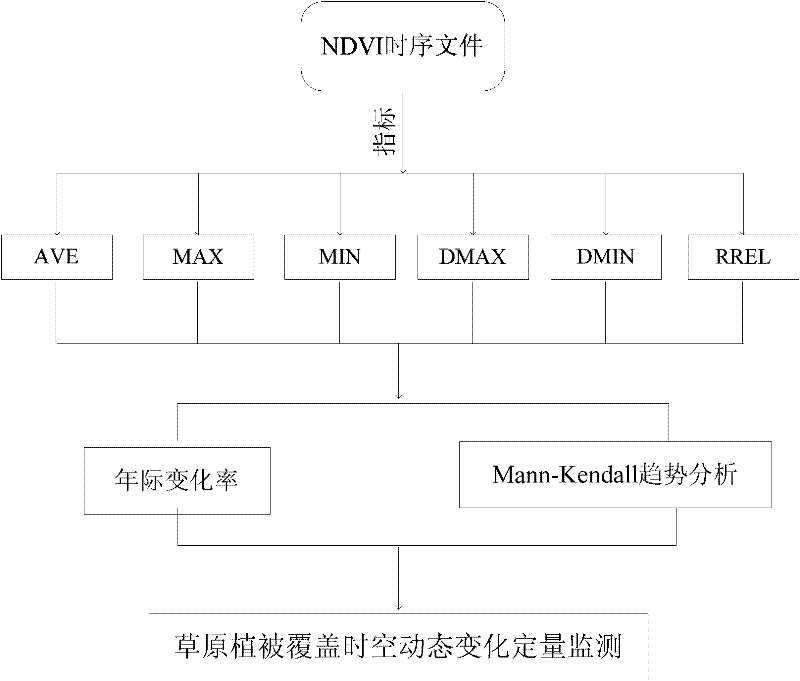
[0052] The remote sensing quantitative monitoring method of the spatial-temporal dynamic change of the grassland vegetation cover involved in the specific embodiment of the present invention, such as figure 1 and figure 2 shown, including the following steps:

[0053] Step S1: Preset the starting year of the statistical year as the time range for quantitatively monitoring the temporal and spatial dynamic changes of grassland vegetation coverage;

[0054] Step S2: Use the SPOT_VGT vegetation NDVI data or other NVDI data of grassland vegetation coverage to make annual NDVI time series files in the preset statistical year, and then eliminate the noise interference of NDVI time series files; specifically: use remote sensin...


PUM


Abstract

The invention relates to a method for remotely sensing and quantitatively monitoring steppe vegetation coverage space-time dynamic change based on normalized difference vegetation index (NDVI) data, and belongs to the technical field of vegetation coverage dynamic remote sensing and monitoring. In order to solve the problem that the quantitative research on remote sensing and monitoring of steppe vegetation coverage dynamic change is rare, the quantitative monitoring method provided by the invention comprises the following steps of: calculating to obtain six NDVI indexes, such as an NDVI yearly value, a yearly maximum value, a yearly minimum value, a yearly maximum value appearance date, a yearly minimum value appearance date and a season dynamic, which represent a steppe vegetation coverage situation, by using an NDVI time sequence file; and quantitatively monitoring a space-time dynamic change process, a phenological characteristic and a dynamic change tendency of steppe vegetation coverage by calculating a yearly dynamic change rate of the NDVI indexes within a certain time period and performing trend analysis by a Mann-Kendall method. The method is applicable to all vegetation NDVI data.

Description

technical field [0001] The invention relates to the technical field of dynamic remote sensing monitoring of vegetation coverage, in particular to a remote sensing quantitative monitoring method for temporal and spatial dynamic changes of grassland vegetation coverage based on vegetation NDVI data. Background technique [0002] Vegetation is the most prominent land cover type on the land surface. It has obvious seasonal and interannual changes. Its temporal and spatial changes have an important impact on the global energy cycle and the biochemical cycle of substances. The change of vegetation cover is in the ecological environment survey , soil and water conservation research, evapotranspiration research and other fields have a wide range of applications. At the same time, the dynamic monitoring and evaluation of vegetation temporal and spatial evolution is an important basis for evaluating ecological protection measures, environmental management policies and global change res...

Claims


Application Information

Patent Timeline
IPC IPC(8): G06F17/18
Inventor 王桥李营
Owner SATELLITE ENVIRONMENT CENT MINIST OF ENVIRONMENTAL PROTECTION
Learn More