Method for roughly sorting high-resolution remote sensing image scene
A remote sensing image, high-resolution technology, applied in the field of remote sensing image processing, can solve the problem of pixel-level classification efficiency and accuracy that does not meet actual needs
- Summary
- Abstract
- Description
- Claims
- Application Information
AI Technical Summary
Problems solved by technology
Method used
Image
Examples
Embodiment Construction
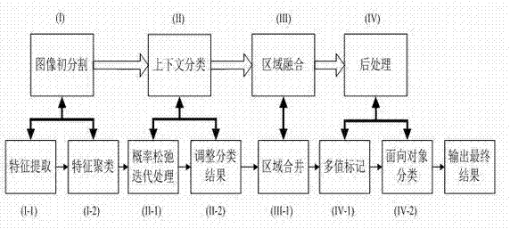
[0050] In this embodiment, a visible light remote sensing image with a resolution of about 3000*3000 is taken as an example to describe the scene classification of the present invention in detail.
[0051] (1) Image initial segmentation
[0052] Firstly, the original image is decomposed by wavelet, using Daubechies 4-point wavelet for first-level decomposition, and 4 sets of wavelet coefficient matrices with doubled resolution are obtained, which are the approximate coefficients of the original image and 3 sets of detail coefficients.
[0053] Next, the Laws texture operator operation is performed on these four groups of wavelet coefficient matrices to obtain the feature vector group describing the original image. This process is roughly as follows: the number of texture categories contained in the image is known, and then all frequency bands LL, HL, LH, HH of the largest scale are decomposed from the wavelet, and a 4-dimensional vector is constructed for each position, and th...
PUM
 Abstract
Description
Claims
Application Information
 - R&D
- Intellectual Property
- Life Sciences
- Materials
- Tech Scout
- Unparalleled Data Quality
- Higher Quality Content
- 60% Fewer Hallucinations
Browse by: Latest US Patents, China's latest patents, Technical Efficacy Thesaurus, Application Domain, Technology Topic, Popular Technical Reports.
© 2025 PatSnap. All rights reserved.Legal|Privacy policy|Modern Slavery Act Transparency Statement|Sitemap|About US| Contact US: help@patsnap.com


