
Method for expanding and updating maps and electronic dictionary

An electronic dictionary and map technology, applied in the direction of electronic digital data processing, special data processing applications, instruments, etc., can solve the problems that electronic maps cannot update records and are not comprehensive enough

Inactive Publication Date: 2011-04-13
WUDI SCI & TECH (XIAN) CO LTD
View PDF0 Cites 11 Cited by
  • Summary
  • Abstract
  • Description
  • Claims
  • Application Information

AI Technical Summary

Problems solved by technology

[0009] In order to solve the problems in the prior art that the electronic map cannot be updated and the records are not comprehensive enough, the present invention provides a method for expanding and updating the map and an electronic dictionary using the method

Method used


Image

  • Method for expanding and updating maps and electronic dictionary
  • Method for expanding and updating maps and electronic dictionary
  • Method for expanding and updating maps and electronic dictionary

Examples


Embodiment Construction

[0035] A method for expanding and updating a map provided by the present invention, its preferred embodiment is:

[0036] The method includes the following steps:

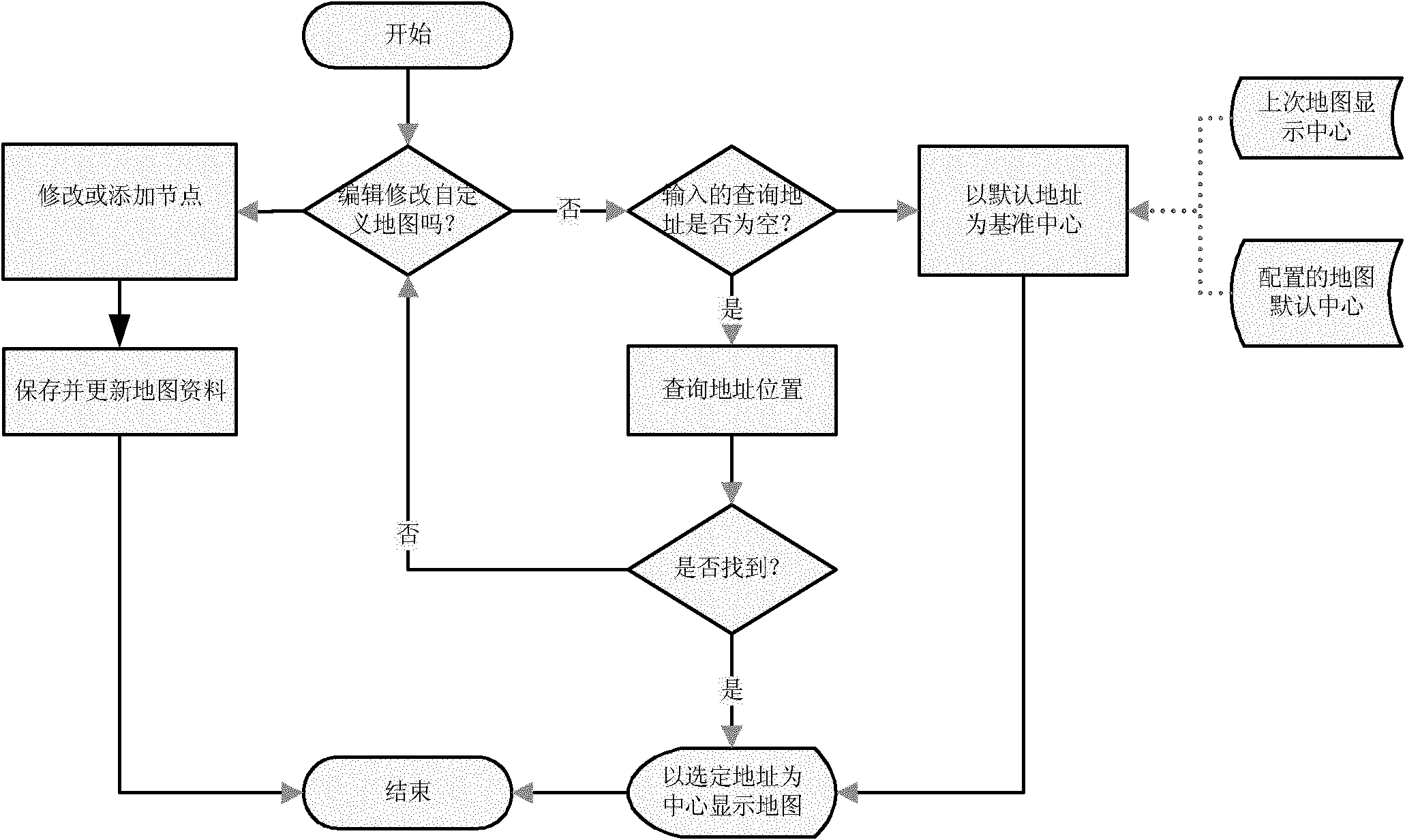
[0037] Step 1) judge whether it is necessary to edit and modify the map, if not, proceed to step 2); if so, proceed to step 5);

[0038] Step 2) Input the address that needs to be queried, and judge whether it is empty; if not; then take the default address as the reference center, and proceed to step 4); if so, then query the location of the address in the map;

[0039] Step 3) determine whether the location of the query address is found, if not, then return to step 1); if so, then proceed to step 4);

[0040] Step 4) displaying the map centered on the selected address;

[0041] Step 5) modify or add node information;

[0042] It specifically includes:

[0043] 5.1) Select one or more datum points, and input the basic information and datum reference information of the increase or decrease locations;

[0044] ...


PUM


Abstract

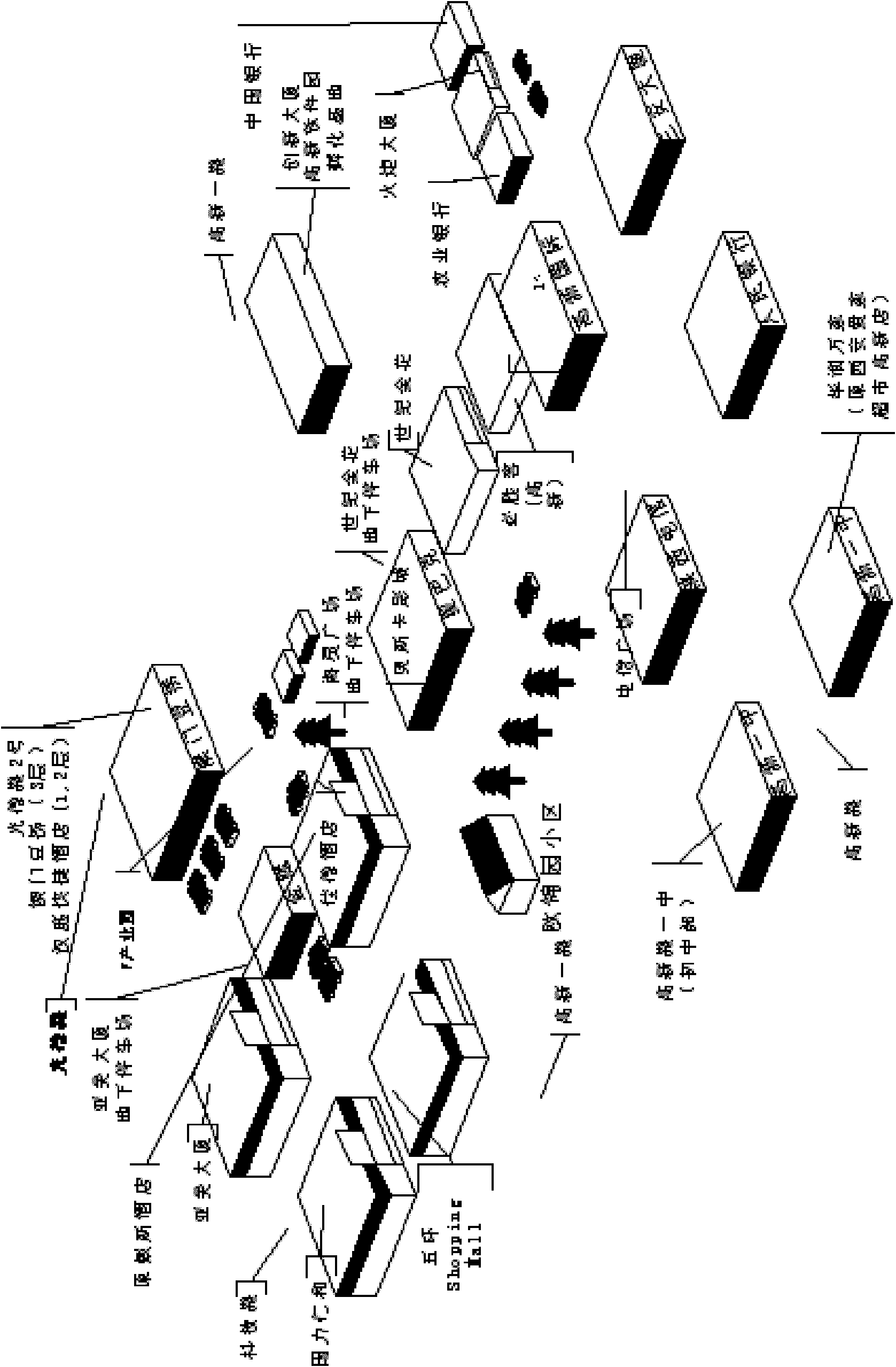
The invention relates to a method for expanding and updating maps and an electronic dictionary. The electronic dictionary comprises an input module, a query module, a storage module and an editing module, wherein the input module is used for inputting addresses to be queried as well as the datum reference information and basis information of added / deleted places; the query module is electrically connected with the input module; the storage module is electrically connected with the query module and used for storing map data; and the editing module is electrically connected with the storage module. In the invention, users are allowed to edit all elements of the maps, such as streets and Block points (buildings, counters, retail sales etc.) without the requirement for positioning information of global position systems (GPS), general packet radio service (GPRS) and the like, thereby further querying schematic diagrams related to geographical positions; and in addition, maps are specifically simplified by taking Road and Block as basic elements, thus users are allowed to edit and create maps conveniently.

Description

technical field [0001] The invention relates to a method for expanding and updating a map and an electronic dictionary using the method. Background technique [0002] The existing maps are basically the developers themselves to integrate geographical location resources. For example, Google has commercial satellites to detect geographic location. The highlighted maps are basically refined according to market demand. Generally, large cities have more detailed information than small and medium cities, developed areas have more detailed information than non-developed areas, and urban areas have more detailed information than suburban areas. [0003] Regardless of whether the map information is released uniformly by the server through the network (Google Maps, Baidu Maps), or a certain version of the map information is embedded (Kay Rucker, Turing, etc.), although users are allowed to customize and add some data (such as the Pin function, as long as Given the latitude and longi...

Claims


Application Information

Patent Timeline
IPC IPC(8): G06F17/30
Inventor 陈淮琰锺辉杨贤
Owner WUDI SCI & TECH (XIAN) CO LTD
Learn More