Ground penetrating radar capable of positioning

A technology of ground penetrating radar and positioning module, which is applied in satellite radio beacon positioning system, electromagnetic wave detection, measuring device, etc. It can solve the problems of difficult to ensure the accuracy of survey line layout, unfavorable radar wave event recognition, single management, etc. question

Inactive Publication Date: 2010-12-08
江苏国明探测设备科技有限公司
View PDF3 Cites 2 Cited by
  • Summary
  • Abstract
  • Description
  • Claims
  • Application Information

AI Technical Summary

Problems solved by technology

In the prior art, the processing and interpretation of the characteristic parameters of ground penetrating radar has been relatively mature. However, in the actual processing of the characteristic parameters to be measured, the ground surface can only be regarded as a plane, and the influence of terrain fluctuations on the detection results is completely ignored. It is not conducive to the identification of the radar wave event. Even if the survey line is arranged according to the data such as remote sensing images or topographic maps, due to the complexity of the actual situation on the site, it is difficult to find the reference object for the survey line layout, and it is difficult to To ensure the accuracy of the survey line layout, in addition, in the management of the characteristic parameters of the ground penetrating radar, the file form is mostly used, the management is single, and the application of radar data information and digitization is low, especially in the conditions of complex terrain and wide area These problems are more prominent when doing a lot of field detection work under

Method used


Image

  • Ground penetrating radar capable of positioning
  • Ground penetrating radar capable of positioning

Examples


Embodiment Construction

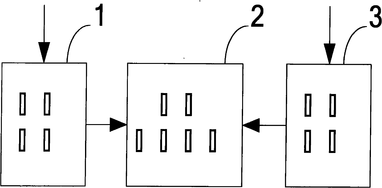
[0014] Such as figure 1 As shown, an embodiment of a positionable ground penetrating radar of the present invention is given.

[0015] The ground penetrating module 1 is connected with the information processing module 2 for the characteristic parameters of the target underground medium, and the characteristic parameters are passed to the information processing module 2; while the ground penetrating module 1 detects, the positioning module 3 acquires the ground penetrating radar synchronously X, Y, Z spatial coordinates, the positioning module 3 preferably adopts a GPS receiver, a Beidou receiver, a Galileo receiver or a GLONASS receiver. GNSS is a satellite-based radio timing positioning and navigation system, which can provide users in aviation, spaceflight, land, ocean, etc. with different precision online or offline space positioning data. The information processing module 2 imports the acquired X, Y, and Z space coordinates of the ground penetrating radar into the GIS gr...


PUM


Abstract

The invention discloses a ground penetrating radar capable of positioning, which comprises a ground penetrating module, a positioning module and an information processing module, wherein the ground penetrating module is connected with the information processing module and used for detecting characteristic parameters of a target underground medium and transferring the characteristic parameters to the information processing module; the positioning module is connected with the information processing module and used for obtaining spatial position information of the target underground medium and transferring the spatial position information to the information processing module; and the information processing module is connected with the ground penetrating module and the positioning module and used for processing the characteristic parameters and the spatial position information. In the invention, the spatial positioning technology is introduced in the ground penetrating radar to carry out topographic correction on the position where each ground penetrating radar is located, and the positioning precision and the detection quality of the detection result of the ground penetrating radar can be improved significantly.

Description

technical field [0001] The invention relates to a positionable ground penetrating radar. Background technique [0002] GPR (Ground Penetrating Radar, Ground Penetrating Radar) is a geophysical exploration method that uses ultra-high-frequency pulsed electromagnetic waves to detect target underground media. The above-mentioned target underground media specifically include: groundwater, bedrock surfaces, pipelines, etc. A broad-spectrum (1MHz-1GHz) electromagnetic technique used to determine the distribution of underground media has been widely used in hydrology, engineering, environment, mining and other fields, and its application range is still expanding. [0003] The workflow of GPR detection includes: ①The characteristics of the target subsurface medium, environmental analysis, and network layout; ②Selection of characteristic parameters to be measured and on-site detection; ③Processing and interpretation of characteristic parameters. In the prior art, the processing and ...

Claims


Application Information

Patent Timeline
IPC IPC(8): G01V3/12G01S19/42
Inventor 张国柱邱兆坤朱畅陆珉李宽
Owner 江苏国明探测设备科技有限公司
Why Eureka
Try Eureka