
A method for real-time simulation of sea level

A real-time simulation, sea level technology, applied in the field of sea level simulation, can solve problems such as the inability to simulate the infinitely vast sea surface

Inactive Publication Date: 2011-12-07
BEIJING CRYSTAL TECH TRAINING LTD
View PDF0 Cites 0 Cited by
  • Summary
  • Abstract
  • Description
  • Claims
  • Application Information

AI Technical Summary

Problems solved by technology

No matter how large the grid is, there are edges, so the simulated sea level cannot simulate the infinitely vast sea surface

Method used


Image

  • A method for real-time simulation of sea level
  • A method for real-time simulation of sea level

Examples


Embodiment Construction

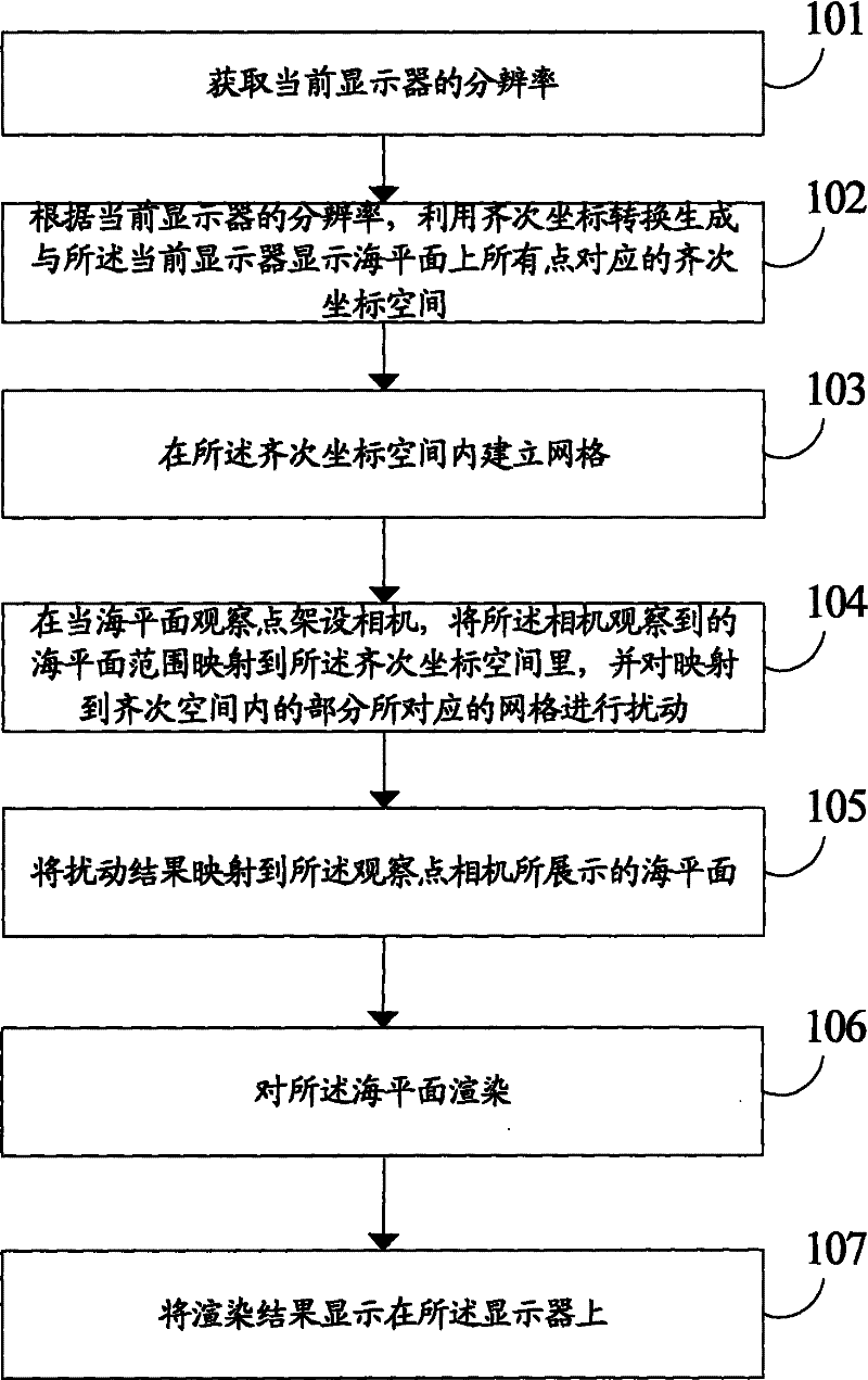
[0025] Please see figure 1 As shown, the present invention provides a method for sea level simulation real-time simulation, which includes:

[0026] Step 101, acquire the resolution of the current display.

[0027] Step 102, according to the resolution of the current display, use homogeneous coordinate transformation to generate a homogeneous coordinate space corresponding to all points on the sea level displayed on the current display.

[0028] In a specific embodiment, the step of using homogeneous coordinate transformation to generate a homogeneous coordinate space corresponding to all points on the sea level displayed on the current display includes:

[0029] Establish the coordinate value (x, y) of each pixel in the orthogonal coordinate system;

[0030] Generate a two-dimensional space [x, y] for each pixel; and

[0031] Generates a two-dimensional homogeneous space [x, y, w] where 0<=w<=1.

[0032] The volume of the homogeneous space generated in this way will be re...


PUM


Abstract

The present invention provides a method for real-time simulation of sea level, which includes: obtaining the resolution of the current display; according to the resolution of the current display, using homogeneous coordinate transformation to generate homogeneous coordinates corresponding to all points on the sea level displayed by the current display Coordinate space; establish a grid in the homogeneous coordinate space; set up a camera at the current sea level observation point, map the sea level range observed by the camera into the homogeneous coordinate space, and map it to the homogeneous coordinate space The grid corresponding to the part in the space is perturbed; the perturbation result is mapped to the sea level displayed by the viewpoint camera; the sea level is rendered; and the rendering result is displayed on the display.

Description

technical field [0001] The invention relates to a method for simulating natural phenomena, in particular to a method for simulating sea level. technical background [0002] In the prior art, the sea level simulation methods basically adopt the grid method, and the grid representation of the sea surface has its own limitations. Due to the size of the grid, the sea level will always have edges. No matter how large the grid is, there are edges, so the simulated sea level cannot simulate the infinitely vast sea surface. Contents of the invention [0003] In view of this, the object of the present invention is to provide a method for simulating sea level in real time. It can simulate infinite sea level, and the amount of calculation is controllable. [0004] In order to achieve the above object, the present invention provides a method for sea level real-time simulation, which includes: [0005] Get the resolution of the current display; [0006] According to the resolution...

Claims


Application Information

Patent Timeline
Patent Type & Authority Patents(China)
IPC IPC(8): G06T17/00
Inventor 黄鹏徐道升魏记
Owner BEIJING CRYSTAL TECH TRAINING LTD
Learn More