Eureka AIR delivers breakthrough ideas for toughest innovation challenges, trusted by R&D personnel around the world.

PDA-based intelligent travel navigation system

A navigation system and intelligent navigation technology, applied in the field of tourism informatization, can solve problems such as deviation of the measured position

Inactive Publication Date: 2010-06-16
BEIJING UNIV OF POSTS & TELECOMM
View PDF0 Cites 36 Cited by
  • Summary
  • Abstract
  • Description
  • Claims
  • Application Information

AI Technical Summary

Problems solved by technology

[0003] In terms of GPS, due to the influence of GPS noise, the actual measured position is often biased

Method used


Image

  • PDA-based intelligent travel navigation system
  • PDA-based intelligent travel navigation system
  • PDA-based intelligent travel navigation system

Examples


Embodiment Construction

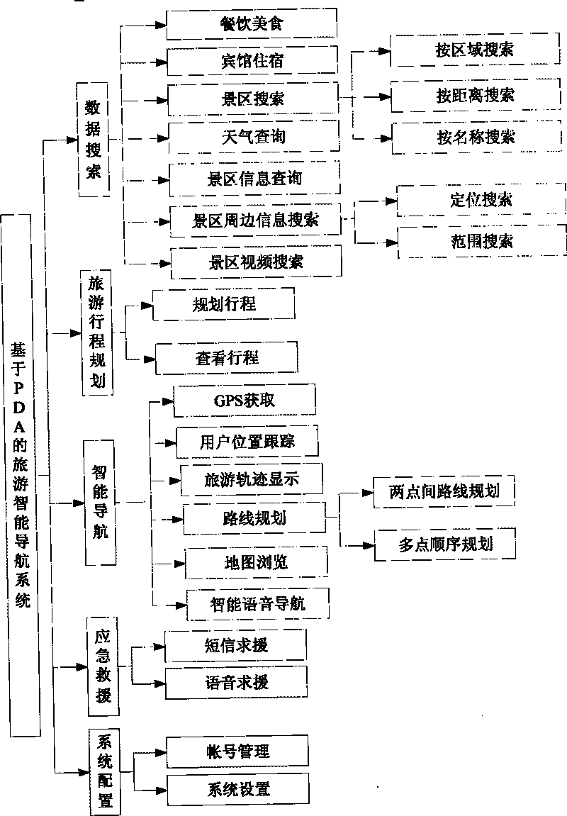
[0024] The system is divided into two parts: PDA and server. The two communicate through the network. PDA is the front desk of the entire system and is the main interface between the system and the user. The server completes the storage and query of information and the management of information in the database. The overall system structure such as figure 1 Shown. PDA function modules such as figure 2 As shown, the system is mainly composed of five parts, namely: data search and query, travel itinerary planning, intelligent navigation, emergency rescue and system configuration.

[0025] 1. Data Search

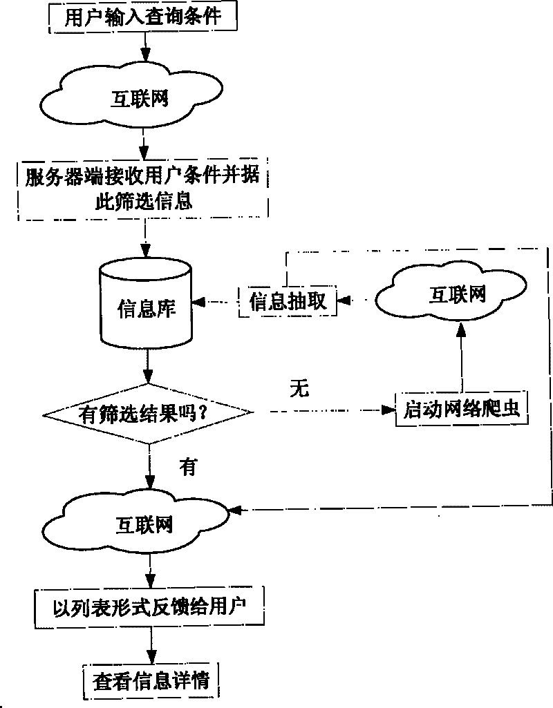
[0026] Data search is an information query based on vertical search technology, which can provide information search related to tourists' travel, such as catering, hotel accommodation, scenic spot information, scenic weather and other information. The technical solutions are as follows image 3 Shown. The functions of each sub-module are introduced below.

[0027] 1.1 Food and Bever...


PUM


Abstract

The invention discloses a PDA-based intelligent travel navigation system. The system comprises a data searching and query module, a travel planning module, an intelligent navigation module, an emergency rescue module and a system configuration module, wherein the data searching and query module can provide real-time information searching and query related to traveling positions of tourists; the travel planning module comprises a travel planning module and a travel looking-over module; and the intelligent navigation module performs GPS data acquisition and processing, user position tracking, user track display, route planning, map browsing and intelligent audio navigation. Under the condition of an emergency, the tourists can ask for help to related departments through the emergency rescue module. The system has strong real-time performance and high application value.

Description

Technical field [0001] The invention belongs to the field of tourism informatization, and specifically relates to GPS-based location information processing, real-time information query, travel itinerary planning, intelligent navigation and emergency rescue. Background technique [0002] The key technology of self-service itinerary navigation is GIS navigation technology. At present, GIS navigation technology at home and abroad is relatively mature. In map matching technology, a Kalman filter model with roads as constraints can be established, and the vehicle's location and direction information can be used to match the vehicle to the correct road. [0003] In terms of GPS, due to the influence of GPS noise, the actual measured position is often biased. To solve this problem, a comprehensive map matching algorithm based on fuzzy logic theory can be used, which fully considers the geometric characteristics of the road and the deviation characteristics of GPS measurement data. In te...

Claims


Application Information

Patent Timeline
Patent Type & Authority Applications(China)
IPC IPC(8): G06Q10/00G06Q50/00G01C21/34G06Q50/14
Inventor 杜军平徐锋颜志伟梁美玉
Owner BEIJING UNIV OF POSTS & TELECOMM
Why Eureka
Eureka Blog
Learn More