
Mobile positioning apparatus

A mobile unit, positioning device technology, applied in positioning, measuring device, satellite radio beacon positioning system and other directions, can solve the problem of not being able to properly reflect different errors of satellites

Inactive Publication Date: 2009-12-16
TOYOTA JIDOSHA KK
View PDF2 Cites 15 Cited by
  • Summary
  • Abstract
  • Description
  • Claims
  • Application Information

AI Technical Summary

Problems solved by technology

However, there is a problem that using the determined weight coefficients cannot properly reflect the different errors of each satellite

Method used


Image

  • Mobile positioning apparatus
  • Mobile positioning apparatus
  • Mobile positioning apparatus

Examples


Embodiment Construction

[0027] A description will now be given of embodiments of the present invention with reference to the accompanying drawings.

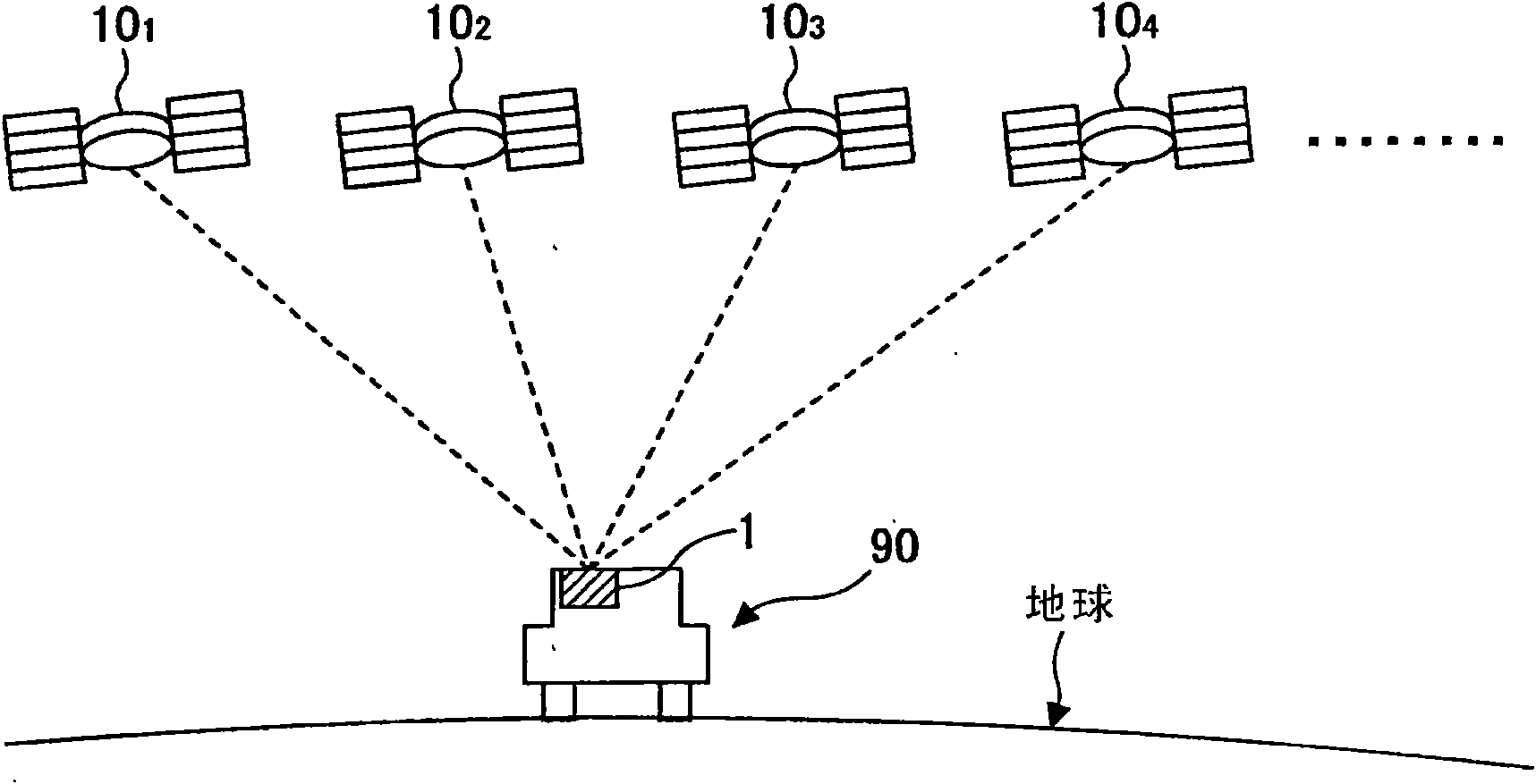
[0028] figure 1 It is a figure which shows the general structure of the GPS (Global Positioning System) to which the mobile unit positioning apparatus in the embodiment of the present invention is applied.

[0029] like figure 1 As shown, the GPS includes GPS satellites 10 orbiting the earth and a motor vehicle 90 on which the vehicle 90 is located and movable over the surface of the earth.

[0030] Vehicle 90 is an example of a mobile unit. Other examples of mobile units include information terminals such as motorcycles, railroad trains, ships, aircraft, fork lifts, robots, and cellular telephones such as mobile phones that move with the movement of their occupants. type of information terminal.

[0031] Each GPS satellite 10 transmits navigation information (satellite signals) to the earth all the time. The navigation information includes satelli...


PUM


Abstract

In a mobile-unit positioning device, phases of pseudo noise codes carried on satellite signals from satellites are observed at a mobile unit to measure a position of the mobile unit. A pseudo distance between one of the satellites and the mobile unit is measured for every satellite during a stop of the mobile unit using an observed value of the phase acquired during a stop of the mobile unit. An error index value indicating an error of the measured distance is computed based on the distances measured at points in time during a stop of the mobile unit. A weighting factor is determined based on the index value computed for every satellite. A weighted positioning computation using the determined weighting factor is performed to determine a position of the mobile unit during movement using an observed value of the phase acquired during movement. The invention also provides an another device capable of measuring position using an analogy method, in this case, the erro criterion is based on the error of the measured mobile unit speed not based on the pseudo distance.

Description

technical field [0001] The present invention relates to a mobile unit positioning device which measures the position of a mobile unit or the like. Background technique [0002] Conventionally, a method of calculating the user's velocity on the earth-centered Cartesian coordinate system and its time offset rate by means of simultaneous velocity equations is known. The simultaneous velocity equations are constructed using the user's position on the geocentric Cartesian coordinate system determined by the simultaneous position equations. Determine the differential value of the velocity with respect to time in the geocentric Cartesian coordinate system by solving the simultaneous velocity equations. Each value required by the user is calculated by obtaining the differential value of the velocity on the geocentric Cartesian coordinate system with respect to time by transforming the geocentric Cartesian coordinate system to the geocentric Cartesian coordinate system at the user's...

Claims


Application Information

Patent Timeline
IPC IPC(8): G01S5/14G01S19/42
Inventor 上田晃宏前田岩夫永宫清美田岛靖裕长谷川直人
Owner TOYOTA JIDOSHA KK
Learn More