Three-dimensional affine transformation method and satellite remote sensing image geometry correction method

A satellite remote sensing image and affine transformation technology, which is applied in image enhancement, image data processing, instruments, etc., can solve the problems of low geometric correction accuracy of line scanner images, difficult multi-sensor triangulation selection, and high model complexity.

Active Publication Date: 2008-07-23
THE HONG KONG POLYTECHNIC UNIV
View PDF0 Cites 3 Cited by
  • Summary
  • Abstract
  • Description
  • Claims
  • Application Information

AI Technical Summary

Problems solved by technology

This is because rigorous mathematical models usually have the following disadvantages: a) high model complexity; b) real-time mathematical models need to transform different sensors; and c) it is difficult to choose appropriate special software for multi-sensor triangulation [1] Madani, M .1999. Real-time sensor-independent positioning by rational functions. ISPRS Workshop on Direct.versus Indirect Methods of Sensor Orientation, Barcelona 280 pages: 64-75.]
However, due to the lack of sensor calibration parameters and spacecraft ephemeris data, the geometric correction of satellite images using the frame and line scan mode

Method used


Image

  • Three-dimensional affine transformation method and satellite remote sensing image geometry correction method
  • Three-dimensional affine transformation method and satellite remote sensing image geometry correction method
  • Three-dimensional affine transformation method and satellite remote sensing image geometry correction method

Examples


Embodiment Construction

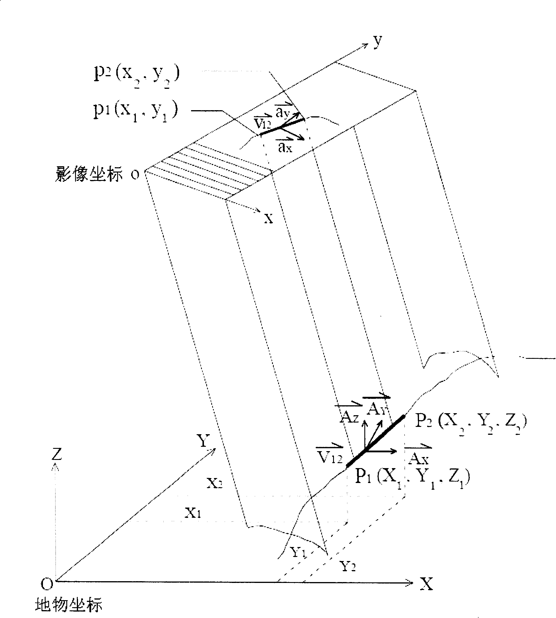
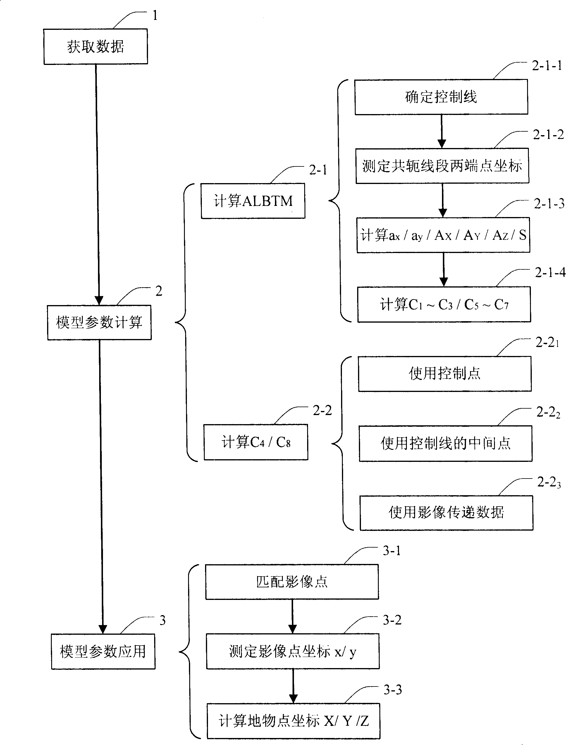
[0072] As mentioned in the background art, there are many bottlenecks in the existing satellite remote sensing image geometric correction technology, which makes it necessary to develop a satellite remote sensing image geometric correction method based on other image features. However, linear features such as valleys, rivers, and roads, as image features that are easy to extract and carry rich information, have received more and more attention in the field of image geometric correction.

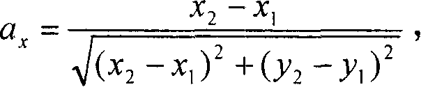
[0073] For this reason, the present invention provides a kind of three-dimensional affine transformation method based on line feature, and this method uses ALBTM (3D Affine Line-Based Transformation Model, three-dimensional affine transformation model based on line feature) to express two-dimensional image space and three-dimensional ground The interconnection between object spaces, and the specific mathematical expression of the ALBTM is

[0074] Sa x =C 1 A X +C 2 A Y +C 3 A Z ,

[...


PUM


Abstract

A three-dimensional affine transformation method employs ALBTM (a three-dimensional affine model based on line feature) to express the relationship between two-dimensional space and three-dimensional space, and the specific mathematical expression of ALBTM is Sax=C1AX+C2AY+C3AZ, Say=C5AX+C6AY+C7AZ, wherein the (ax, ay) are unit vector components of a line-segment in two-dimensional space, the (AX, AY, AZ) are unit vector components corresponding to a conjugate line segment of the line-segment in the three-dimensional space, the S is the proportional divisor of the line-segment and the conjugate line segment, the C1-C3 and C5-C7 are rotary parameters of the ALBTM. Disclosed also is geometry correction method of satellite remote sensing images, which includes step 1 obtaining at least two satellite remote sensing images data, step 2 respectively computing the model parameter for three-dimensional affine transformation of image space and terrain space of each satellite remote image on the basis of the image data and by the three-dimensional affine transformation method, step 3 defining the coordinate of center point of the image space in the terrain space according to the model parameter.

Description

technical field [0001] The invention relates to image geometric correction, in particular to three-dimensional affine transformation technology and satellite remote sensing image geometric correction using the three-dimensional affine transformation technology. Background technique [0002] In recent decades, perspective geometry and projection methods have formed the basis for geometric correction of frame camera images. In this case, the collinear equation, as a rigorous mathematical model, describes the projection relationship between the 2D (Two Dimension, two-dimensional) image space and the 3D (Three Dimension, three-dimensional) object space. However, unlike frame cameras, satellite remote sensing images are based on the principle of line imaging, and each line is imaged at a different time. Therefore, the application of rigorous mathematical models for geometric correction of satellite remote sensing images requires advance prediction of spacecraft orbit, attitude a...

Claims


Application Information

Patent Timeline
IPC IPC(8): G06T17/00G06T5/00
Inventor 艾麦德·夏德嘉史文中
Owner THE HONG KONG POLYTECHNIC UNIV
Why Eureka
Try Eureka