
User queries to model road network usage

a road network and user query technology, applied in the field of digital information processing, can solve problems such as less informative maps

Active Publication Date: 2014-09-02
GOOGLE LLC
View PDF6 Cites 19 Cited by
  • Summary
  • Abstract
  • Description
  • Claims
  • Application Information

AI Technical Summary

Benefits of technology

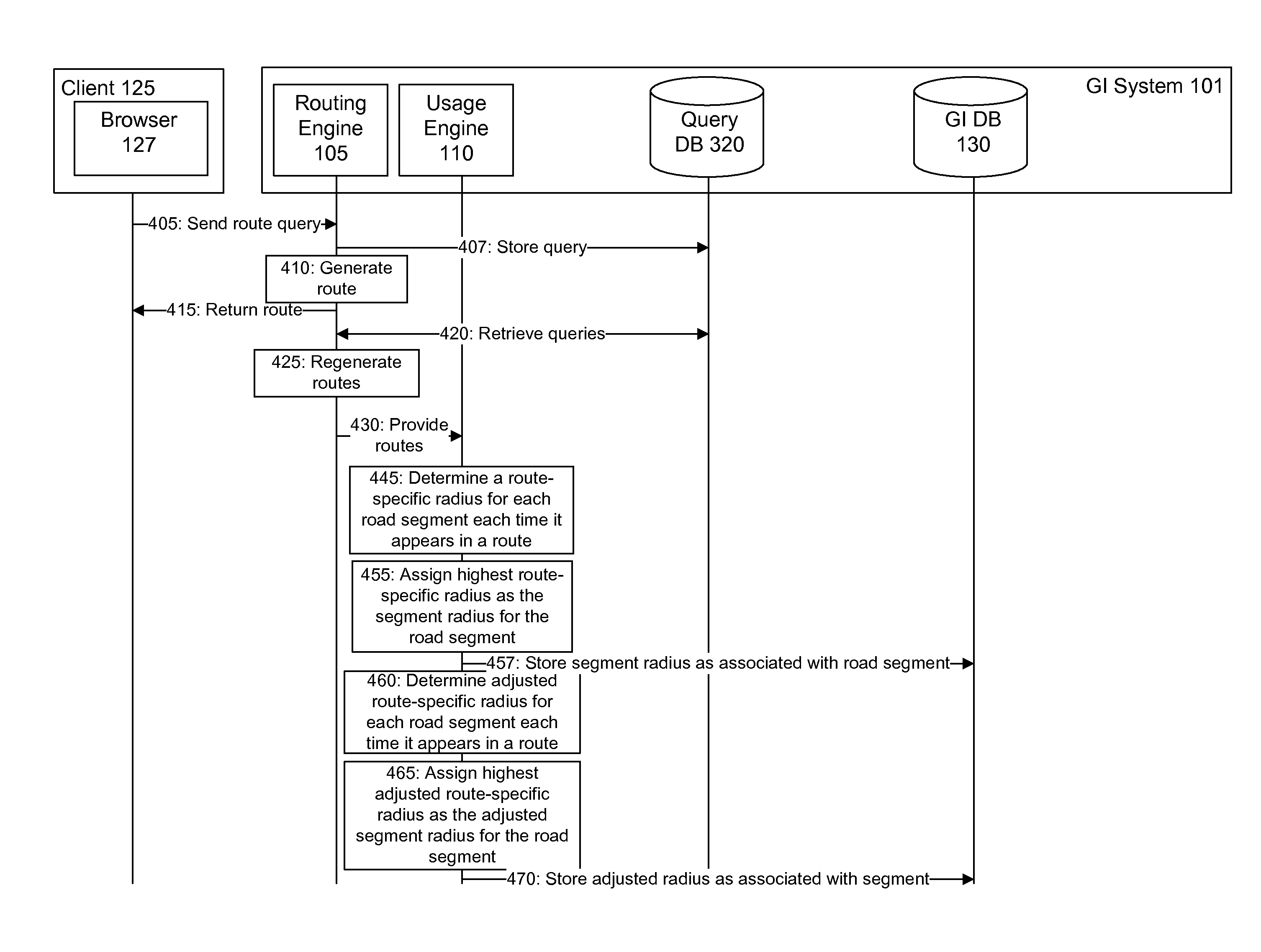
The patent describes a system and method that analyzes routing directions between endpoints on a map to determine usage characteristics of roads. This is done by analyzing road segments that make up the roads and determining the routes that users took to get to those segments. The system calculates a score for each segment based on the distance from the start of the route to the segment and the distance from the end of the route to the segment. The highest score is determined for each segment and then adjusted based on the scores of adjacent segments to create an overall score for the segment. This analysis helps to better understand how people use the roads and can be displayed on a map for reference.

Problems solved by technology

Which roads to display on a map at a particular zoom level is one area which can lead to maps being less informative than they could be.

Method used


Image

  • User queries to model road network usage
  • User queries to model road network usage
  • User queries to model road network usage

Examples


Embodiment Construction

[0021]The Figures (FIGS.) and the following description describe certain embodiments by way of illustration only. One skilled in the art will readily recognize from the following description that alternative embodiments of the structures and methods illustrated herein may be employed without departing from the principles described herein. Reference will now be made to several embodiments, examples of which are illustrated in the accompanying figures. It is noted that wherever practicable similar or like reference numbers may be used in the figures and may indicate similar or like functionality.

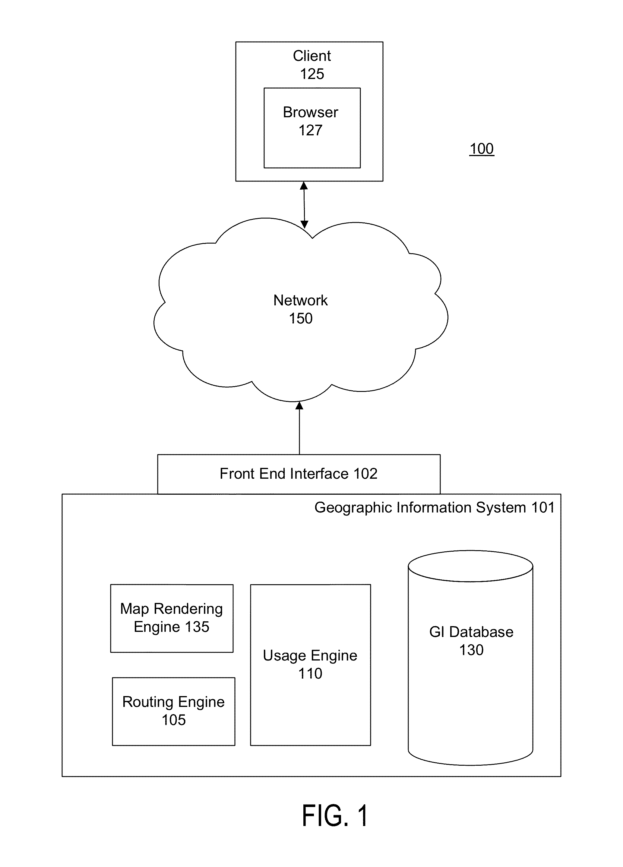
[0022]FIG. 1 is a high-level block diagram illustrating an environment 100 for analyzing user queries for routes to model road network usage. The environment 100 includes a geographic information (“GI”) system 101 which communicates with a client 125 via a front end interface 102 of the GI system 101 and a network 150.

[0023]A client 125 is a computing device executing software that requests ma...


PUM


Abstract

A system and method determines a plurality of scores for a road segment that are related to the total distance traveled when drivers traverse that road segment. The scores are displayed graphically to illustrate the usage of road segments. The scores are also used to determine which road segments to display on a map when determining which roads to display at a given zoom level for a map.

Description

RELATED APPLICATIONS[0001]This application claims the benefit of U.S. Provisional Application No. 61 / 390,578, filed Oct. 6, 2010, which is hereby incorporated by reference herein.BACKGROUND[0002]1. Field of Art[0003]The present invention relates generally to the field of digital information processing, and more specifically to generating and analyzing routes based on digital maps.[0004]2. Background of the Invention[0005]Digital maps, such as those provided by GOOGLE INC., are used in a wide variety of electronic devices, such as car navigation systems and mobile phones. Users rely on digital maps, as well as routes generated in response to queries for directions between places on the digital maps, to provide comprehensive and accurate information about roads and other geographic features for purposes including navigation and education. Therefore, the map data should be as accurate and complete as possible.[0006]Which roads to display on a map at a particular zoom level is one area ...

Claims


Application Information

Patent Timeline
IPC IPC(8): G01C21/00
CPCG01C21/3453G01C21/32G01C21/3667G01C21/00G01C21/34G01C21/367
Inventor KADOUS, MOHAMMED WALEEDARFVIDSSON, JOAKIM KRISTIAN OLLE
Owner GOOGLE LLC
Learn More