Nautical waypoints and routes data sets

a waypoint and route technology, applied in surveying and navigation, navigation instruments, instruments, etc., can solve the problems of reducing the need for continuous and laborious calculation, prone to careless errors, and difficult to achieve the effect of maximizing frank—notepad.43 and facilitating safe passag

Inactive Publication Date: 2005-03-08
JOKERST SR JOHN B
View PDF1 Cites 38 Cited by
  • Summary
  • Abstract
  • Description
  • Claims
  • Application Information

AI Technical Summary

Benefits of technology

It is a further objective of the invention to correlate route information with marine charts of the same area, including, but not limited to, electronic charts such as those produced by GARMIN—“Waterways and lights and BlueChart” to permit the user to plan a route using marine charts and to then download from the database of the invention all of the necessary uniquely named waypoints for that particular route and to save the cartography so produced as a composition showing the waypoints and routes in an electronic file such as that used in the GARMIN MapSource program.
The present invention teaches the need for additional fields and features not found in prior art systems as follows, Fields for “Charts”, “Feature properties” (i.e. Warning information such as DO NOT USE AT LOW TIDE) “Remarks” and the ability to access “pop-up” windows for a given chart feature to dynamically interface with the GPS unit and add or delete information in the data base. Provide within the GPS system a simple printing method for outputting data either the electronic charts or the database such that simple nautical “trip tickets” can be produced to facilitate navigation of the vessel, while preservation of marine symbol terminology not featured in newer electronic charts—“red triangle”, “red triangle with gold bar”, “green square with gold bar” (Gold bar denotes inter coastal waterway).
Since the present invention provides electronic media containing pre-compiled data sets for given routes, a user need only load the media into a computer connected to a GPS device and download the data. This produces displays of distance between waypoints and true bearing between each point. True bearing is used to assist those who are unfamiliar with any deviations in their compass and, since true bearings are used for charting, those who prefer to chart courses on applicable navigation charts need no correction for variation or deviation in addition to using a GPS. The present invention provides printing capabilities allowing the user to produce hard copies of the data sets being used, providing thereby a backup data set in the event of power loss or failure of the GPS at which time dead reckoning can be used.
To establish a computer file of routes:42. Maximize FRANK—notepad.43. Highlight all of the route(s).44. Under Edit select Copy and minimize the Notepad.45. Maximize the second untitled spreadsheet and in the Tool bar select Copy.46. Click and drag each column until all wording in each column is exposed.47. Insert any titles or notes as appropriate.48. Save the untitled spreadsheet to “My Documents” with a specific file name. Example: FROUTES.49. Print out FWAYPTS and FWAYPTS to create separate written copies of the waypoints and routes.50. To save the MapSource cartography, maximize the untitled Cartographic map and “Save” using a file name such as FRANK.mps. The above steps, 1-50 comprise all of the steps used to create the present invention which consists of a unique cartographic MapSource document and Microsoft WINDOWS files that can be printed out to show all pertinent information relative to those waypoints and routes.51. To load routes and waypoints into a (Garmin) GPS, open an untitled MapSource document.52. From a Master MapSource file, Copy and Paste the appropriate Routes into the untitled MapSource file.53. Connect the computer to a Garmin GPS using an interface cable.54. Turn on the GPS and remove all current routes and waypoints.55. From the untitled MapSource document select Save to device. A pop up window will appear.56. If the GPS is not a chart plotter, check Waypoints and Routes. If it is a chart plotter select All. If the GPS uses Chips, select Waypoints and Routes.57. Click on Save and the computer generated Charts, Routes and Waypoints in a matter of seconds / moments will be saved into your GPS.New waypoints and routes can be uploaded into the computer using the remaining steps.58. Connect the computer to a (Garmin) GPS using an interface cable.59. Open an untitled MapSource document, select Open from device. A pop up window will appear.60. Check Waypoints and Routes.61. Click on Save and the GPS generated Routes and Waypoints will be saved into the computer.62. If the GPS fails, turn on your backup battery powered hand held GPS.63. In the event the backup GPS's batteries are dead, it will be possible to use the hard copies of the waypoints and routes in conjunction with the appropriate Waterproof Charts to establish a dead reckoning course to the next waypoint. Passage can be continued by establishing fixes and positions and using time speed and distance formulas to establish arrival times. By the use of TVMDC the course can be adjusted from true to compass. The depth finder and other aids to navigation would further facilitate safe passage.

Problems solved by technology

Thumbing is an effective but sometimes laborious way to enter the data especially if complicated data is entered when even slight errors can prove disastrous to safe navigation Prior art GPS systems have not provided a method to easily print out data.
They are informative and easy to follow but are useful only for automobile travel there is no equivalent system for marine use utilizing marine charts.
This process takes skill in order to achieve accurate numbers and is prone the careless errors by even experienced navigators.
Over time a user would accumulate databases of such information for a particular area and the need for continuous and laborious calculation would diminish.
Again the margin for potential course errors is increased exponentially by the fact that many hundreds or even thousands of boaters are forced to establish their own waypoints and routes etc.

Method used


Image

  • Nautical waypoints and routes data sets
  • Nautical waypoints and routes data sets
  • Nautical waypoints and routes data sets

Examples


Embodiment Construction

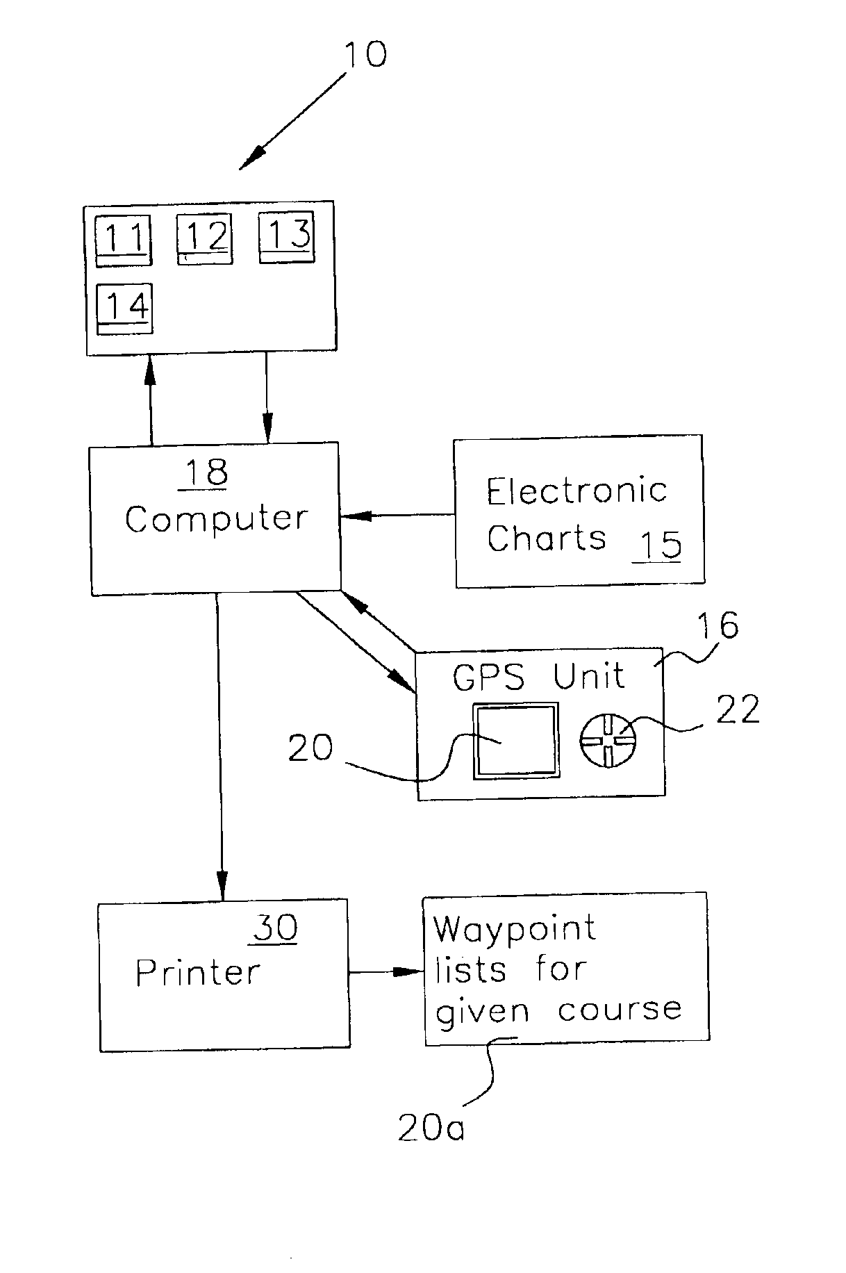
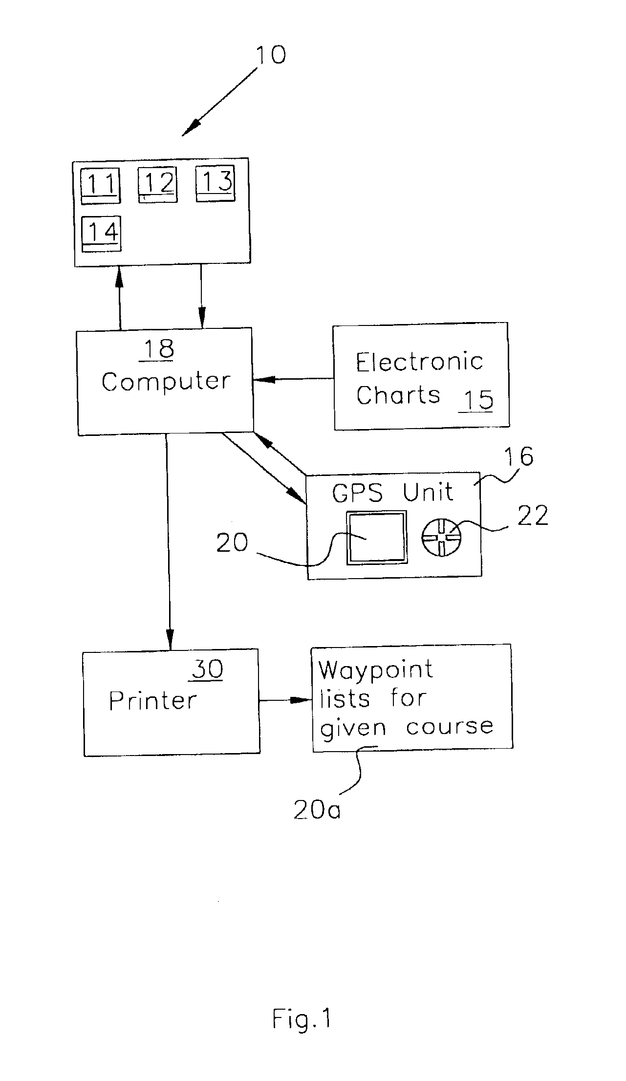
Referring now to FIG. 1 wherein the invention method is designated overall by the numeral 1011-4 are process steps involved in assembling the route data for inputting into computer 18 namely, data collection 11 concerning common routes used in given geographical areas (using electronic chart 15). Data sources include but are not limited to, anecdotal data from individual boaters, fishermen, boat / yacht clubs, marinas and municipal facilities. Testing route 12 found in 11 by comparing them to up-to-date charts of the area. Compiling waypoint lists for given routes 13. Inputting data 14 found in 13 into computer 18. Actual Example: 20a.

Waterproof Charts:

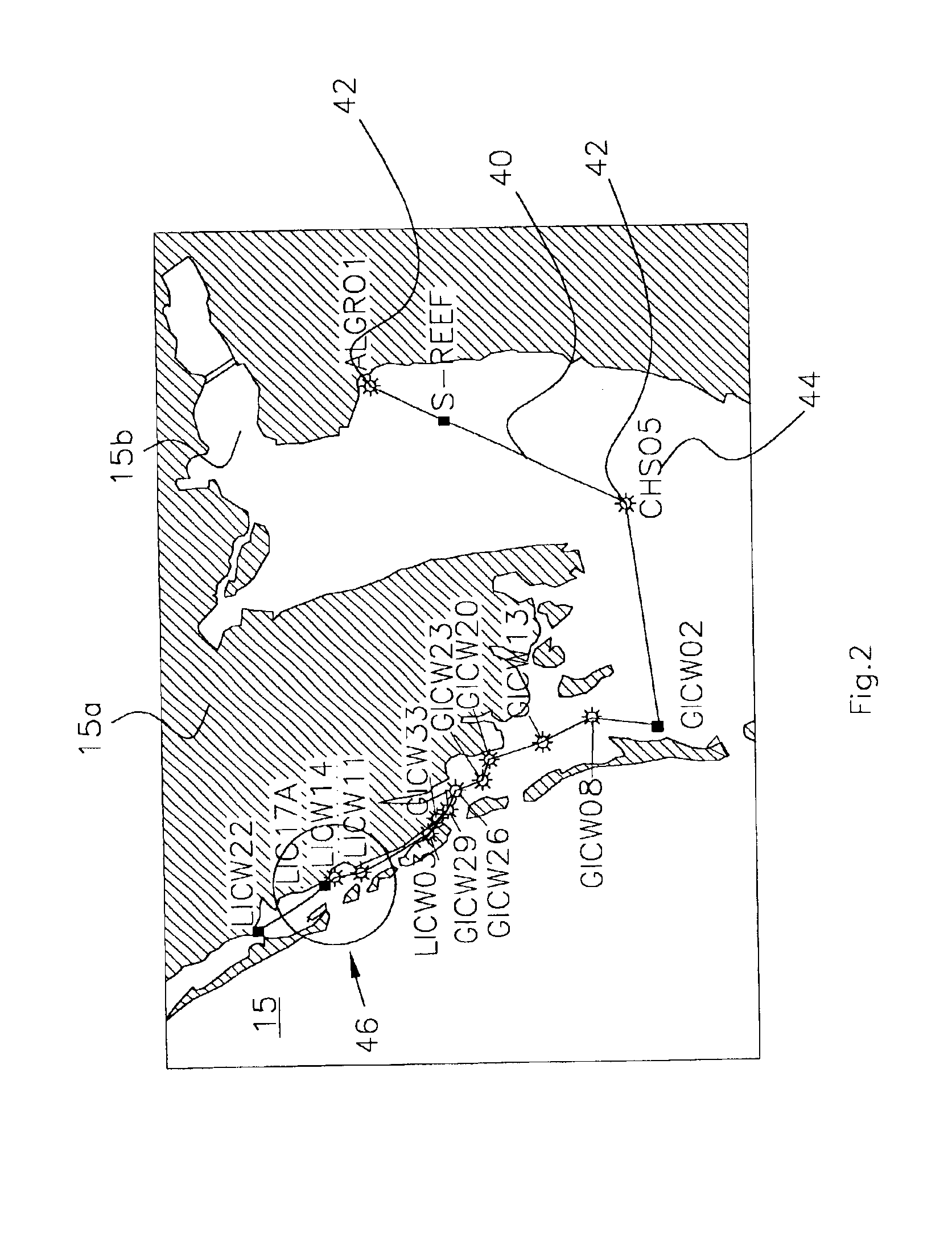
Chart No. 1—United States of America NAUTICAL CHART symbols,abbrev. & terms. (USED WITH ALL CHARTS)01E—Charlotte Harbor and Pine Island Sound25E—Barrier Islands, Boca Grande to Estero Bay

HeaderNameLengthCourseWaypointsRoutePGORD2 to21.7 mi213° true6PICW76waypointsWaypointLegHeaderNameDistanceLengthCourseRoute WaypointPGORD2 0 ftRoute Wa...


PUM


Abstract

A system for calculating waypoints and routes for marine navigation by pre-calculating the routes and waypoints, saving the results to databases contained within electronic media such as CD ROMs, floppy discs, and disseminating copies to mariners for use with prior art global positioning systems devices in common use in the marine industry. The mariner is enabled to send the information on a disc for use on other global positioning systems devices and to superimpose uniquely named waypoints and routes, which contain additional fields and features not found in prior art systems.

Description

FIELD OF INVENTIONThis invention relates generally to devices and methods for calculating waypoints and routes for marine navigation and more particularly, to the pre-calculation of routes and waypoints, saving the results to databases and contained within electronic media and disseminating copies to mariners for use with prior art global positioning devices in common use in the marine industry.With the advent of electronic navigation devices using global positioning satellites, marine navigation has become safer and with GPS system becoming more affordable, compact Nav Stations have become commonplace among commercial and recreational boaters.Prior art GPS systems such as those manufactured by GARMIN are small units having a screen and various controls for connecting the device and controlling it. Inputting data into the device is accomplished by the use of toggle switches usually manipulated by the thumb. Moving the toggles presents various screen options for inputting data, the u...

Claims


Application Information

Patent Timeline
Patent Type & Authority Patents(United States)
IPC IPC(8): G01C21/00G01C21/20
CPCG01C21/20
Inventor JOKERST, SR., JOHN B.
Owner JOKERST SR JOHN B
Why Eureka
Try Eureka