
Systems and methods for enriching geographically delineated content

a technology of geographical delineation and content, applied in the field of systems and methods for enriching geographical delineated content, can solve the problems of ineffective grouping of related media posts, limited conventional services for providing content, and inherently lacking location information of social media content providers posts, etc., to achieve robust and detailed depiction, efficient and accurate relating of media posts

Inactive Publication Date: 2015-06-18
CO EVERYWHERE
View PDF26 Cites 41 Cited by
  • Summary
  • Abstract
  • Description
  • Claims
  • Application Information

AI Technical Summary

Benefits of technology

The patent describes a system that enhances social media content by adding relevant information based on the location where the content is generated. This system uses data from multiple social media platforms to create a more organized and interconnected view of the content. By automatically adding enrichment data to the content, users can find and interact with more relevant content. The system also allows users to filter and group the content based on their preferences. Overall, this system provides a more efficient and effective way to manage and analyze social media content.

Problems solved by technology

Conventional location-based social media content providers connect users with a variety of artificial criteria that do not permit the exchange of relevant information in real-time communication.
Furthermore, conventional services for providing content are limited in the content that can be distributed or associated with additional information.
For instance, many media posts provided by social media content providers inherently lack one or all of location information, topic information, author information, or other information that would be useful for a user of the service to understand the story told by the media post.
Furthermore, this lack of information unnecessarily encumbers the search for relevant information and makes grouping related media posts inefficient.
For instance, conventional services do not permit a user to filter aggregated content based on an author influence level because this information is not provided by the content provider.
Unfortunately, with such conventional services a user is required to parse through searched content to ascertain the relevant information.
Such a process is wasteful and time consuming.

Method used


Image

  • Systems and methods for enriching geographically delineated content
  • Systems and methods for enriching geographically delineated content
  • Systems and methods for enriching geographically delineated content

Examples


example enrichment

Systems and Methods

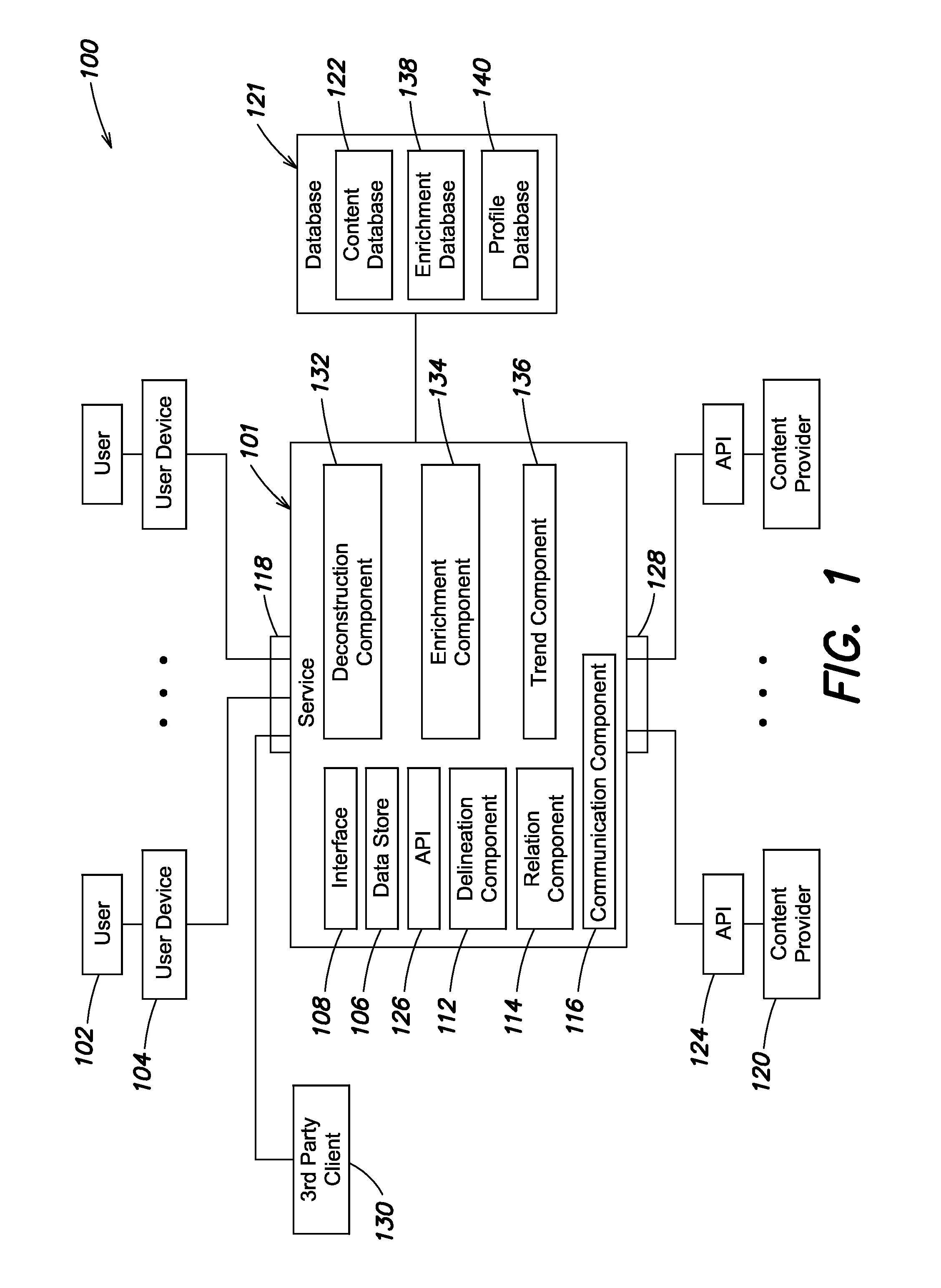
[0137]Returning to FIG. 1, wherein a block diagram of a location-based service and system suitable for incorporation of various aspects of the present invention is shown, in various embodiments the service may aggregate enrichment data and enhance a plurality of media posts within geographically delineated content aggregated from one or more content providers. For instance, the service may permit one or more users (e.g., user 102) to request and receive enriched aggregated geographically delineated content associated with the user's input identifying a geographic location. Users may operate the interface of the user device 104 to interact with the system 100 to receive enriched aggregated geographically delineated content. In other embodiments, the service may permit the one or more third party client systems (e.g., client 130 shown in FIG. 1) to request and receive enriched aggregated geographically delineated content associated with the client's input identifyin...

example trending

Systems and Methods

[0182]Returning to FIG. 1, wherein a block diagram of a location-based service and system suitable for incorporation of various aspects of the present invention is shown, in various embodiments the service may detect an incongruity from a comparison of one or more enriched sets of aggregated geographically delineated content. For instance, the service may permit one or more users (e.g., user 102) to receive a detected trend in enriched aggregated geographically delineated content associated with the user's input identifying a geographic location. For example, the detected trend may include a percentage increase in author's posting in the North end neighborhood of Boston, Mass. Trends permit a user to analyze or discover the source of social media tendencies. Trends may also include percentage increases in a volume of media posts associated with a particular topic, or top hashtags, top @mentions, or locations, such as venues. Users may use the interface of the user...

example interfaces

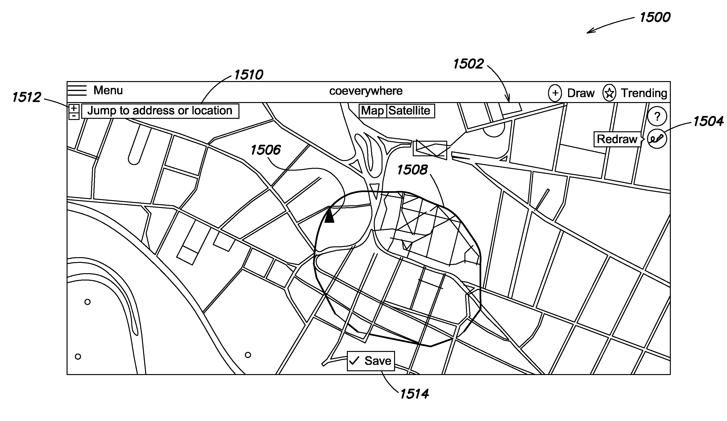
[0218]FIG. 15A shows one example interface in which a user or client may enter an input defining a geographic location according to one embodiment. In various embodiments, user interfaces, as discussed herein, may include one or more interface components configured to receive the entered input. In particular, the interface 1500 includes a visual representation of a geographic image (e.g., map 1502). In one embodiment, the interface includes a map query 1510 permitting the user, or client, to call a desired map or map dimensions. For example, the map query 1510 can enable the user to call a map for Boston, Mass., Suffolk County, or the State of Massachusetts. Furthermore, the embodiment can further include a view indicator 1512 permitting the user, or client, to zoom-in or zoom-out on the map 1502. The interface 1500 may also include a drawing tool indicator 1504 that provides a drawing tool (e.g., tool 1506) permitting the user, or client, to interact with the map 1502 to define the...


PUM


Abstract

Systems and methods are provided that enhance and provide geographically delineated content. In one implementation, a system comprises a location-based service including a distributed computer system having at least one processor, a delineation component configured to query at least one social media content provider and aggregate geographically delineated content including a plurality of media posts each generated by an author, a deconstruction component configured to automatically deconstruct individual media posts of the plurality of media posts into a plurality of dimensions, an enrichment component configured to: automatically aggregate enrichment data related to one of the dimensions of each of the individual media posts, enrichment data including at least author profile information associated with an author profile of the author that generated the respective media post, and responsive to aggregating the enrichment data, enhancing the plurality of media posts with the enrichment data to generate enriched aggregated geographically delineated content.

Description

RELATED APPLICATIONS[0001]This application is a Continuation in Part of U.S. patent application Ser. No. 14 / 572,270, titled “Systems and Methods for Providing Geographically Delineated Content,” filed Dec. 16, 2014, which is incorporated herein by reference in its entirety. U.S. patent application Ser. No. 14 / 572,270 claims priority under 35 U.S.C. §119(e) to U.S. Provisional Patent Application Ser. No. 61 / 963,849 entitled “Methods of Geographic Delineation,” filed on Dec. 16, 2013, which application is herein incorporated by reference in its entirety. U.S. patent application Ser. No. 14 / 572,270 also claims priority under 35 U.S.C. §119(e) to U.S. Provisional Patent Application Ser. No. 61 / 963,850 entitled “Content Provision by Geographic Delineation,” filed on Dec. 16, 2013, which application is herein incorporated by reference in its entirety. U.S. patent application Ser. No. 14 / 572,270 further claims priority under 35 U.S.C. §119(e) to U.S. Provisional Patent Application Ser. No....

Claims


Application Information

Patent Timeline
Patent Type & Authority Applications(United States)
IPC IPC(8): H04L29/08G06F17/30H04L12/58
CPCH04L67/18G06F17/30864H04L51/32G06F16/951H04L51/222H04L51/52H04L67/52
Inventor LONGO, ANTHONYADAMS, DANIEL ALAN
Owner CO EVERYWHERE
Learn More