
Mobile terminal capable of measuring altitude and altitude measurement method using the same

Inactive Publication Date: 2014-01-09
KOREA INST OF SCI & TECH +1
View PDF8 Cites 42 Cited by
  • Summary
  • Abstract
  • Description
  • Claims
  • Application Information

AI Technical Summary

Benefits of technology

The present invention aims to solve the problems of conventional mobile terminals by providing a mobile terminal that can measure altitude using a barometric pressure sensor. This allows for accurate 3D location information to be provided, based on the reception of GPS information. Additionally, the invention combines digital map data information of a building with altitude information to measure the floor on which the mobile terminal is located. Overall, this invention provides improved accuracy and efficiency in measuring altitude and location information.

Problems solved by technology

However, there is a disadvantage in that the location of the mobile terminal based on GPS information is mainly indicated by a two-dimensional (2D) location, that is, only by the latitude and longitude of a place at which the mobile terminal is currently located, and the location of an altitude can be neither indicated nor tracked.
When a location is determined based on current GPS information, it is impossible to receive GPS information in an indoor area, so the determination of a location is difficult, or a location different from the current location is indicated, and the determination of a location in a high-rise building is impossible.
However, there have been problems pointed out that make it difficult for mobile terminal users in such an environment to determine an accurate location using only 2D location information when determining or transmitting their locations within a high-rise building, particularly when an emergency evacuation situation, such as a fire or a terror, occurs and the users must transmit their location information or request location tracking.
That is, when persons placed in an evacuation situation are respectively located on the second floor and the 13th floor of a building, current technology makes it possible to receive only GPS information corresponding to the same location, so that unless evacuees request rescue from an area outside the high-rise building, it is difficult to determine an accurate height.
As a result, there is a disadvantage in that a search operation cannot be specified, thus causing rescue operations to be inevitably limited.

Method used


Image

  • Mobile terminal capable of measuring altitude and altitude measurement method using the same
  • Mobile terminal capable of measuring altitude and altitude measurement method using the same
  • Mobile terminal capable of measuring altitude and altitude measurement method using the same

Examples


Embodiment Construction

[0021]Hereinafter, operations and effects of a mobile terminal capable of measuring an altitude and an altitude measurement method using the mobile terminal according to the present invention, together with technical configuration for the objects of the present invention, will be more clearly understood from the following detailed description taken in conjunction with the accompanying drawings which show preferred embodiments of the present invention.

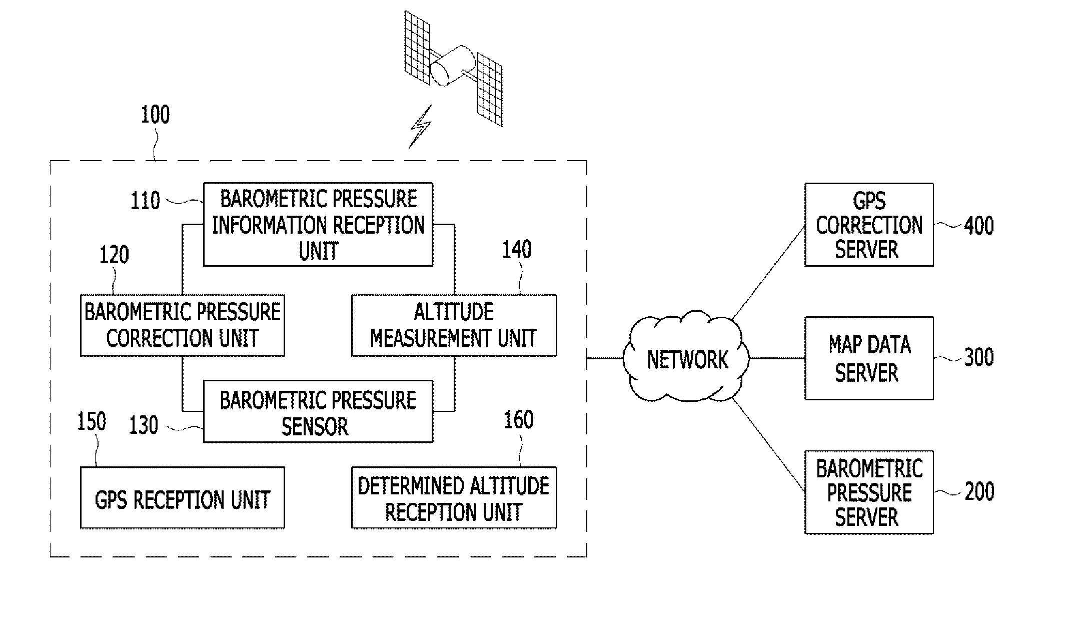
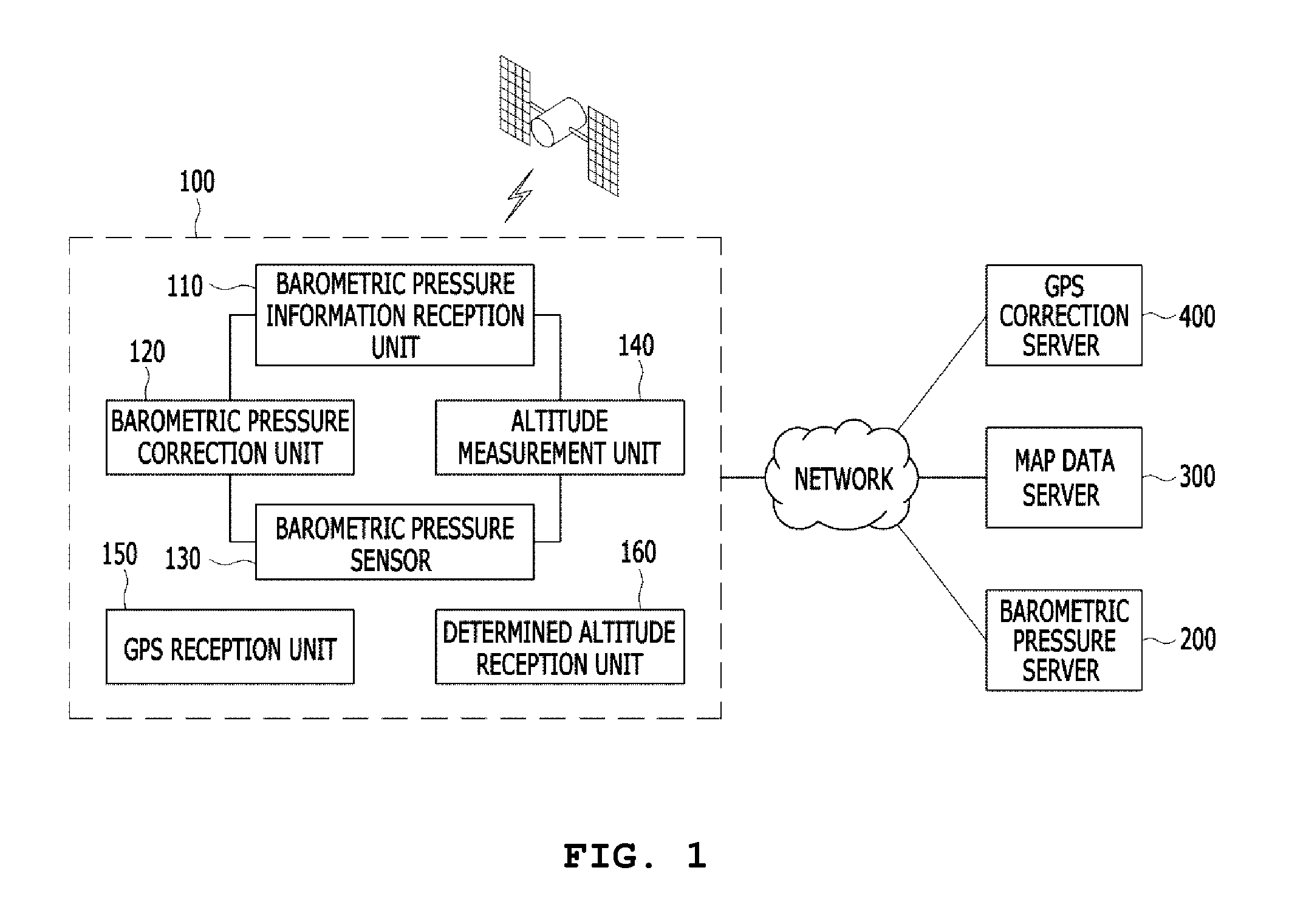
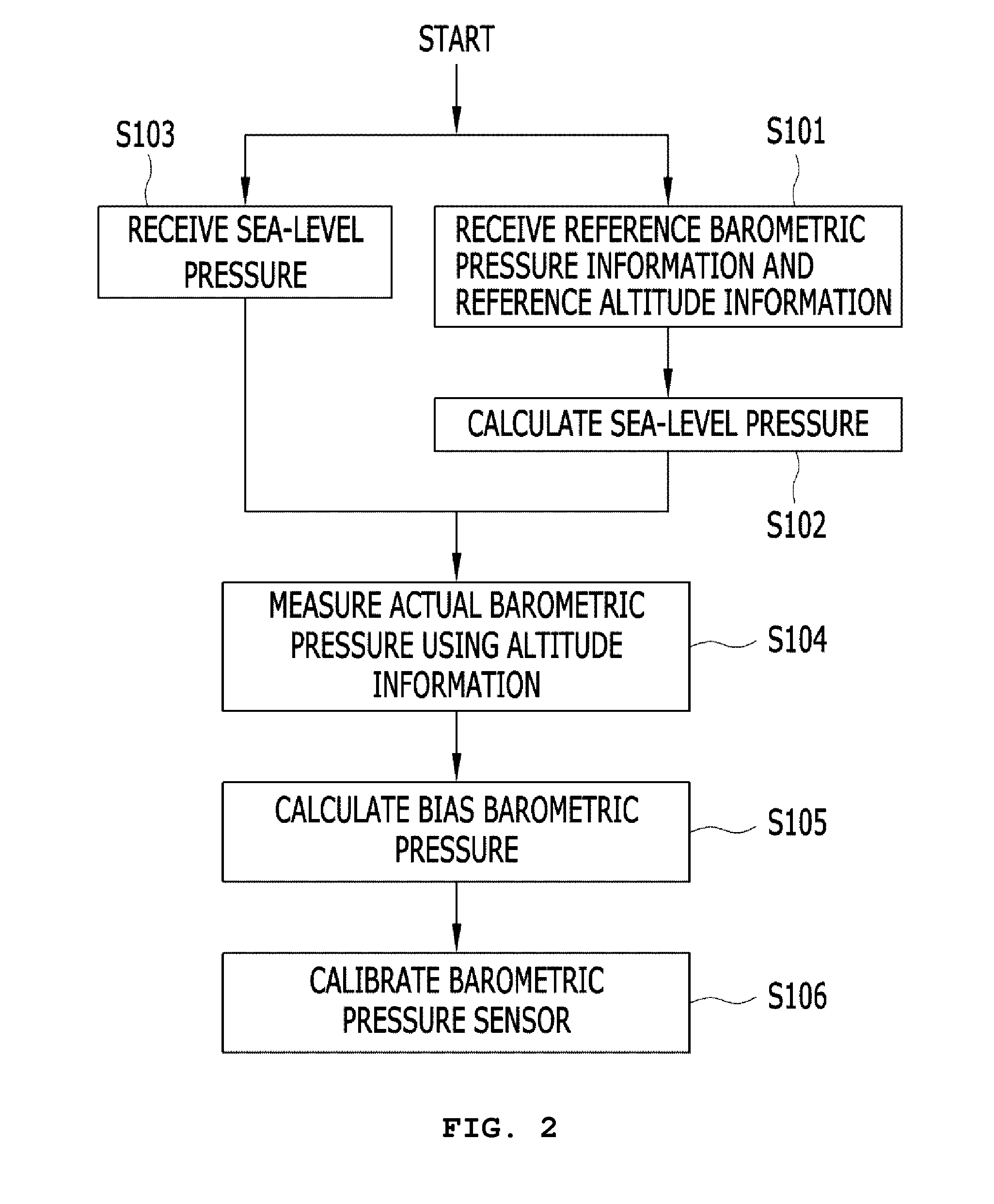
[0022]FIG. 1 is a configuration diagram showing a mobile terminal capable of measuring an altitude according to the present invention. As shown in the drawing, a mobile terminal 100 capable of measuring an altitude according to the present invention is connected to a wireless communication means over a network, may include a barometric pressure information reception unit 110 for receiving barometric pressure information over the network, a barometric pressure correction unit 120 for calculating a bias barometric pressure using the recei...


PUM


Abstract

The present invention relates to a mobile terminal capable of measuring an altitude and an altitude measurement method using the mobile terminal. The mobile terminal capable of measuring an altitude includes a barometric pressure information reception unit for receiving barometric pressure information, a barometric pressure correction unit for calculating a bias barometric pressure using the barometric pressure information received by the barometric pressure information reception unit, and a barometric pressure sensor for outputting a corrected barometric pressure to which the bias barometric pressure is applied.

Description

BACKGROUND OF THE INVENTION[0001]1. Field of the Invention[0002]The present invention relates, in general, to a mobile terminal capable of measuring an altitude and an altitude measurement method using the mobile terminal and, more particularly, to a mobile terminal capable of measuring an altitude and an altitude measurement method using the mobile terminal, which can provide accurate altitude information of a terminal user using a barometric pressure sensor mounted in the mobile terminal.[0003]2. Description of the Related Art[0004]Mobile communication devices, including recently developed smart phones, are each equipped with a Global Positioning System (GPS) receiver. GPS-based services are provided in the form of various types of applications executed using a location determination function, a current location transmission function, and location-based functions based on GPS technology.[0005]Typical GPS-based services are provided in such a way as to determine location informatio...

Claims


Application Information

Patent Timeline
IPC IPC(8): G01C5/06
CPCG01C5/06G01C15/00G01S19/01H04W88/02
Inventor LEE, TAIK JINKIM, JAE HUNLEE, SEOKLEE, HYUK JAELEE, JUNG HOCHO, YOUNGSUPARK, SANGJOONSHIN, BEOM JUKIM, CHULKI
Owner KOREA INST OF SCI & TECH
Learn More