
Assisting vehicle navigation in situations of possible obscured view

a technology of assisting vehicle navigation and obscured view, which is applied in the field of image processing, can solve problems such as difficulty in the landing process, dust landing effect, and small particles on the ground to become airborn

Inactive Publication Date: 2012-07-12
RAFAEL ADVANCED DEFENSE SYSTEMS
View PDF6 Cites 45 Cited by
  • Summary
  • Abstract
  • Description
  • Claims
  • Application Information

AI Technical Summary

Benefits of technology

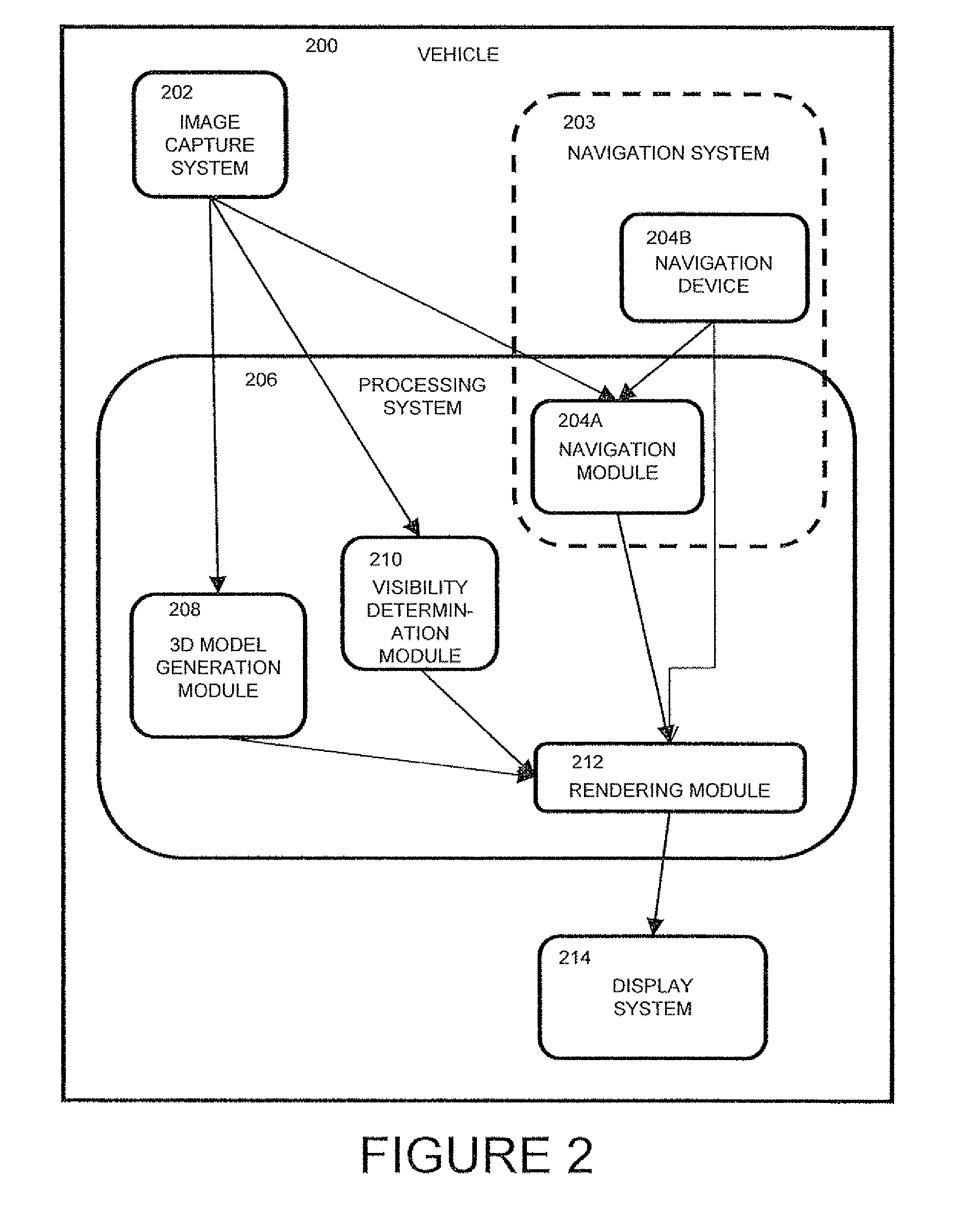
[0012]According to the teachings of the present embodiment there is provided a system for assisting navigation of a vertical takeoff and landing vehicle in circumstances where there is a possibility of the view being obscured, including: an image capture system including at least one image capture device, the image capture system associated with the vehicle and configured to provide images of a landing zone; a navigation system providing the attitude and position of the vehicle; a processing system including one or more processors, the processing system being configured to: provide a three-dimensional model of the landing zone; process images captured during the vehicle's l

Problems solved by technology

The main difficulty in the process of landing occurs during the final moments of the landing.
Experienced pilots relate that landing is the biggest challenge of flying their aircrafts, taking the greatest amount of training to learn and the greatest amount of skill to perform.
When a helicopter flies close enough to the ground, the downwash from the rotors can cause small particles on the ground to become airborne.
When the helicopter's airspeed drops below the effective translational lift (ETL) speed, the helicopter is flying in its own recirculating downwash and airborne particles, or dust landing effects become an issue.
These airborne particles can obscure the view of the ground, in particular the view of the landing zone.
The leading cause of landing accidents is related to dust landings.
Helicopter dust landings are a US$100 million per year problem for the U.S. Military in Afghanistan and Iraq.
As one example, dust-landing accidents destroyed or severely damaged four AH-64D Apache Longbows in the first three weeks of the 2003 Iraq invasion, while only one had been lost in combat.
The display does not include a real image of the landing area and hence does not provide the pilot with the confidence needed to proceed with a landing.

Method used


Image

  • Assisting vehicle navigation in situations of possible obscured view
  • Assisting vehicle navigation in situations of possible obscured view
  • Assisting vehicle navigation in situations of possible obscured view

Examples


Embodiment Construction

[0032]The principles and operation of this system and method according to the present embodiment may be better understood with reference to the drawings and the accompanying description. The present invention is a system and method for assisting navigation of a vehicle in circumstances where there is a possibility of the view being obscured. The following is a non-limiting description of the circumstances where this system and method are used.

[0033]Referring to FIG. 1A is a diagram of a vehicle approaching a landing zone. In the context of this document, the term vehicle is used to refer to a vertical takeoff and landing vehicle (VTOL), such as a helicopter, tilt-wing aircraft, or craft that operates similarly. The concept of this invention can also be applied to different platforms in similar situations, such as landing a submersible craft on an ocean floor. The vehicle 100 has a view of the landing zone 102 from a distance. During the approach of the vehicle to the landing zone, t...


PUM


Abstract

Restrictions of conventional techniques for assisting navigation of a vertical takeoff and landing vehicle in circumstances where there is a possibility of the view being obscured, can be overcome by using a three-dimensional model in combination with image processing to determine which segments of a landing zone are visible and which segments are obscured. A pilot is provided with a view of the landing zone that is a combination of live images and simulated segments from the three-dimensional model. Whereas conventional techniques focus on generating better simulated views, an implementation of this invention includes generating a view of an obscured landing zone that includes live imager. Fusing live imagery with other sensor information to generate a view allows the pilot to use a much real information as possible, and facilitates increased pilot confidence that the pilot can proceed and execute a successful landing.

Description

FIELD OF THE INVENTION[0001]The present embodiment generally relates to the field of image processing and in particular, it concerns a system and method for using augmented reality to provide a view of an obscured landing zone.BACKGROUND OF THE INVENTION[0002]Helicopters are required to land in a variety of locations. The main difficulty in the process of landing occurs during the final moments of the landing. During the final moments of a landing, it is critical that the pilot has knowledge of the landing site and the relation of his aircraft to the site. Experienced pilots relate that landing is the biggest challenge of flying their aircrafts, taking the greatest amount of training to learn and the greatest amount of skill to perform.[0003]To execute a safe landing, pilots want to have the maximum possible amount of information about the landing site. Pilots want information and feedback as to where the ground and surrounding objects are in relation to the position of their aircra...

Claims


Application Information

Patent Timeline
IPC IPC(8): H04N7/18
CPCG01C21/00G08G5/025G08G5/0021
Inventor SHADMI, OFIR
Owner RAFAEL ADVANCED DEFENSE SYSTEMS
Learn More