Oblique photography unmanned aerial vehicle surveying and mapping system and device

A technology of oblique photography and UAV, which is applied in the field of UAV surveying and mapping, can solve the problems of inability to adjust the tilt angle of the camera and affect the accuracy of 3D modeling, and achieve the effect of eliminating geometric deformation of images and improving accuracy

Inactive Publication Date: 2022-03-29
淳安县土地勘察测绘规划设计有限公司
View PDF1 Cites 1 Cited by
  • Summary
  • Abstract
  • Description
  • Claims
  • Application Information

AI Technical Summary

Problems solved by technology

The oblique photography UAV surveying and mapping system in the above patent and the UAV in the device cannot adjust the inclination angle of the camera during measurement, which affects the accuracy of the subsequent three-dimensional modeling of oblique photography

Method used


Image

  • Oblique photography unmanned aerial vehicle surveying and mapping system and device
  • Oblique photography unmanned aerial vehicle surveying and mapping system and device
  • Oblique photography unmanned aerial vehicle surveying and mapping system and device

Examples


Embodiment 1

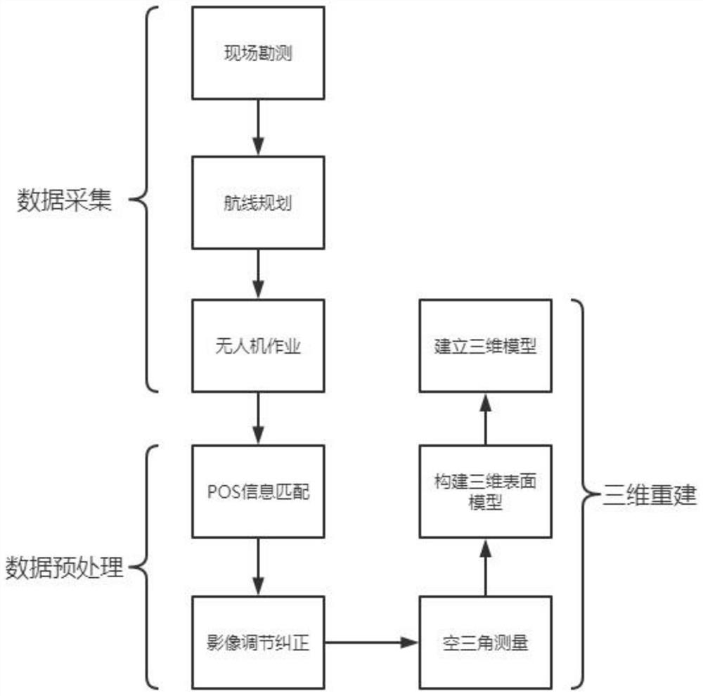
[0045] An oblique photographic UAV surveying and mapping system, such as figure 1 As shown, it specifically includes the following steps:

[0046] S1: data acquisition;

[0047] S2: data preprocessing;

[0048] S3: 3D reconstruction.

[0049] In order to ensure the accuracy of data collection; figure 1 As shown, the step S1 data collection includes the following steps:

[0050] S11: Site survey;

[0051] S12: route planning;

[0052] S13: UAV operation.

[0053] In order to ensure that the photography is clear when the drone is operating; figure 1 As shown, the ground resolution formula of the UAV operation in the step S13 is:

[0054]

[0055] in:

[0056] gsd - ground resolution;

[0057] H-relative flying height;

[0058] f-the focal length of the camera lens;

[0059] a - pixel size.

[0060] In order to ensure the effectiveness of data preprocessing; such as figure 1 As shown, the data preprocessing in the step S2 includes the following steps:

[0061] S21...

Embodiment 2

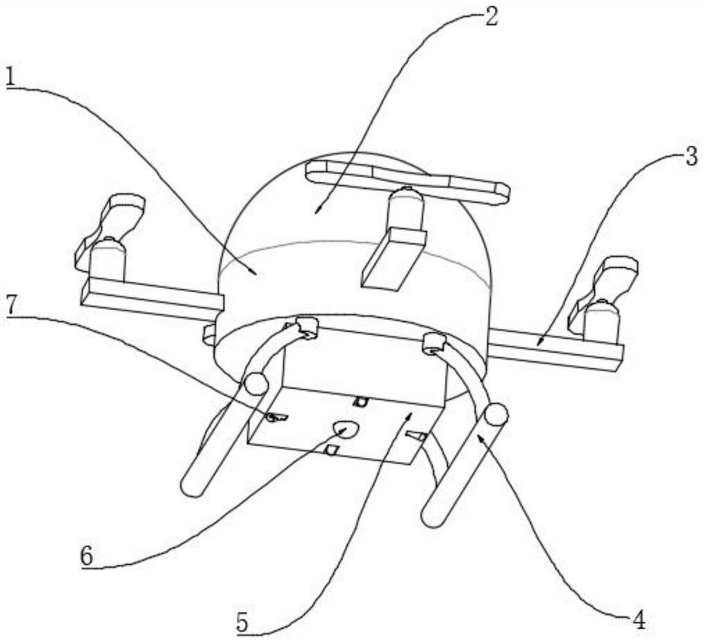
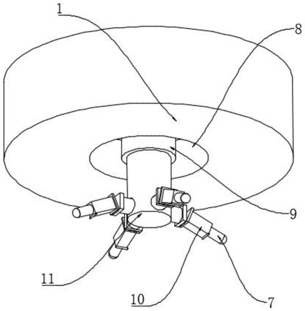
[0069] A device for oblique photographic drone mapping systems such as Figure 2-4 As shown, the UAV body 1 including the UAV operation in step S13; the outer wall of the top of the UAV body 1 is fixedly connected with the arc top 2; the outer wall of the UAV body 1 is fixedly connected with evenly distributed elevating paddles Wing 3; the bottom outer wall of the drone body 1 is fixedly connected with a buffer protection bracket 4; the bottom outer wall of the drone body 1 is fixedly connected with a camera housing 5; the bottom outer wall of the camera housing 5 is fixedly connected with a vertical camera 6; the camera housing 5 The outer wall of the bottom end is processed with evenly distributed square holes; the outer wall of the bottom end of the drone body 1 is processed with a placement groove 8; the outer wall of the bottom end of the placement groove 8 is fixedly connected with an electric telescopic rod 9; Connected with a support link 11; the outer wall of the supp...


PUM


Abstract

The invention discloses an oblique photography unmanned aerial vehicle surveying and mapping system and device, and relates to the technical field of unmanned aerial vehicle surveying and mapping. The problem that the inclination angle cannot be adjusted when an unmanned aerial vehicle is used for oblique photography during surveying and mapping is solved. The system comprises the following steps: data acquisition; preprocessing the data; and performing three-dimensional reconstruction, wherein the device comprises an unmanned aerial vehicle body for unmanned aerial vehicle operation in the step S13; the outer wall of the top end of the unmanned aerial vehicle body is fixedly connected with an arc-shaped roof; and uniformly distributed lifting paddles are fixedly connected to the outer wall of the periphery of the unmanned aerial vehicle body. When the inclination of the inclined camera needs to be adjusted, only an electric telescopic rod needs to be operated, so that a supporting connecting rod moves up and down, a telescopic connecting rod moves up and down along with the supporting connecting rod, the bottom of a fixed supporting column fixedly rotates on the inner side of the camera shell and is connected with the telescopic connecting rod, and then the telescopic connecting rod moves in a built-in groove and the fixed supporting column rotates; therefore, the inclination of the inclined camera is changed, and the inclination angle during photographing is adjusted.

Description

technical field [0001] The invention relates to the technical field of unmanned aerial vehicle surveying and mapping, in particular to an oblique photography unmanned aerial vehicle surveying and mapping system and device. Background technique [0002] Oblique photogrammetry technology comprehensively perceives complex scenes in a large-scale, high-precision, and high-definition way, and the data results generated by efficient data acquisition equipment and professional data processing procedures intuitively reflect the appearance, location, height and other attributes of ground objects. Realistic effects and surveying-level accuracy are guaranteed. At present, in the existing technology, when the oblique photography technology of the UAV is used to measure the specified location, the angle of the oblique photography cannot be changed during the survey, which affects the flexibility of the measurement angle. Therefore , there is an urgent need for an oblique photography UAV ...

Claims


Application Information

Patent Timeline
IPC IPC(8): G01C11/04G01C11/34B64D47/00
CPCG01C11/04G01C11/34B64D47/00
Inventor 章光来吕芸孙鸣陈翔洪凯冬
Owner 淳安县土地勘察测绘规划设计有限公司
Why Eureka
Try Eureka