Grid-based high-precision satellite navigation and positioning service system

A satellite navigation and positioning service technology, applied in the field of satellite positioning, can solve the problems of limited carrying capacity of users of precise positioning services and not meeting the protection design of safety level, etc., so as to save resource costs and meet the effect of protection design.

Pending Publication Date: 2021-06-29
交信北斗科技有限公司 +1
View PDF11 Cites 3 Cited by
  • Summary
  • Abstract
  • Description
  • Claims
  • Application Information

AI Technical Summary

Problems solved by technology

[0016] The purpose of the present invention is to provide a grid-based high-precision satellite navigation and positioning service system, which can solve the technical problems

Method used


Image

  • Grid-based high-precision satellite navigation and positioning service system
  • Grid-based high-precision satellite navigation and positioning service system
  • Grid-based high-precision satellite navigation and positioning service system

Examples


Embodiment Construction

[0073] In order to make the object, technical solution and advantages of the present invention clearer, the present invention will be further described in detail below in combination with specific embodiments and with reference to the accompanying drawings. It should be understood that these descriptions are exemplary only, and are not intended to limit the scope of the present invention. Also, in the following description, descriptions of well-known structures and techniques are omitted to avoid unnecessarily obscuring the concept of the present invention.

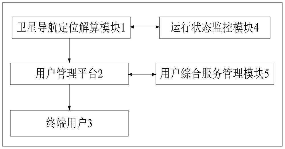
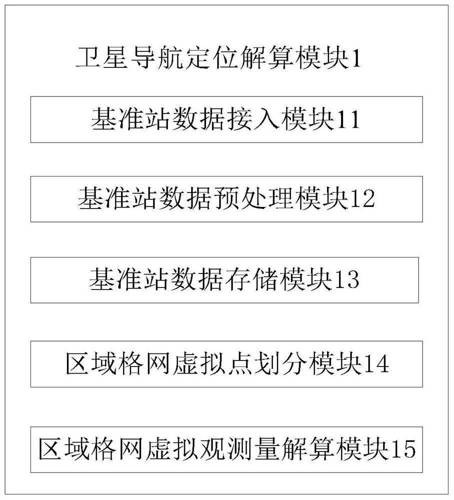
[0074] Such as figure 1 As shown, the present invention provides a grid-based high-precision satellite navigation and positioning service system, including a satellite navigation and positioning calculation module 1 , a user management platform 2 and an end user 3 . Among them, the satellite navigation positioning calculation module 1 is used to access the reference station data and perform calculation processing, thereb...


PUM


Abstract

The invention provides a grid-based high-precision satellite navigation and positioning service system, which comprises a satellite navigation and positioning resolving module, a user management platform and a terminal user, and is characterized in that the satellite navigation and positioning resolving module is used for resolving reference station data to obtain regional enhanced data information; the user management platform is used for managing and authenticating a terminal user, the authenticated terminal user sends an enhanced data information request to the user management platform, meanwhile, the terminal user sends an approximate position of the terminal user, and according to information uploaded by the terminal user, the user management platform selects the virtual observed quantity of a certain corresponding grid point from the regional enhanced data information as difference information of the user, and sends the difference information and the position coordinates of the grid point to the terminal user. According to the invention, only a fixed number of grid point virtual reference stations are calculated through the satellite navigation positioning calculation module, the calculation is not related to the number of terminal users, and the consumed resources are fixed, so that the resource cost can be greatly saved.

Description

technical field [0001] The invention relates to the technical field of satellite positioning, in particular to a grid-based high-precision satellite navigation and positioning service system. Background technique [0002] The implementation steps of network RTK positioning technology can be summarized into the following three points: [0003] First, the baseline calculation is performed based on the observation data of the CORS network, and the ambiguity parameters on each baseline are fixed. The exact fixation of the ambiguity parameters determines the calculation accuracy of various spatial correlation errors. The distance between the current CORS network reference stations is generally long, and the fixation of long-distance baseline ambiguity is the key technology of network RTK. [0004] Secondly, when the ambiguity parameters are fixed accurately and timely, the coefficients of the modified model are calculated. [0005] Finally, the data processing center obtains t...

Claims


Application Information

Patent Timeline
IPC IPC(8): G01S19/43
CPCG01S19/43
Inventor 刘源翔杜聪慧吴海乐李晶李阳蔡磊磊
Owner 交信北斗科技有限公司
Why Eureka
Try Eureka