
Earth-rock volume measuring and calculating method based on unmanned aerial vehicle inverse modeling technology

An earthwork and unmanned aerial vehicle technology is applied in the field of earthwork measurement and calculation based on UAV inverse modeling technology. Material and financial resources, the effect of reducing the frequency of measurement

Pending Publication Date: 2021-06-25
CHINA CONSTR FIRST BUILDING GRP CORP LTD +1
View PDF1 Cites 2 Cited by
  • Summary
  • Abstract
  • Description
  • Claims
  • Application Information

AI Technical Summary

Problems solved by technology

[0002] Traditional methods of earthwork measurement and calculation, such as grid, scatter method, and table method, are often limited by measurement tools and terrain, and the RTK (Real-time kinematic, real-time dynamic) carrier phase difference technology introduced in recent years is also expensive due to equipment , Strong professionalism and cannot be applied to project engineering at any time
Therefore, the earth and stone measurement method in the prior art has the following disadvantages: ① depends on the manual operation of surveyors, and field surveying and mapping cannot guarantee the safety of surveying and mapping personnel; ②RTK equipment is expensive and professional, and cannot be applied to project projects at any time; ③ surveying and mapping and It takes a long time to calculate the amount of earthwork
However, there are some defects in this invention. This method does not set target control points in the area to be measured, but only designs and plans the take-off and landing positions, heights and routes of the UAV, so the accuracy of the 3D model obtained in this way is relatively low.
In this method, it is mentioned that the calculation of earthwork engineering quantity needs to be calculated manually combined with engineering drawings, and the calculation workload is complicated. At the same time, this method does not specify the data collection process of earthwork engineering quantity, the formation process of 3D model, and the crucial calculation process, so the operability is relatively low. Low

Method used

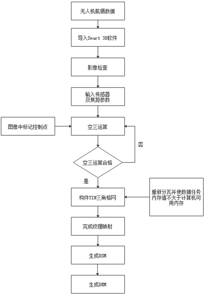
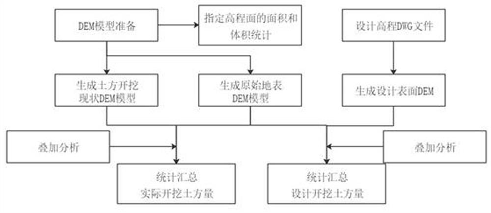

Image

  • Earth-rock volume measuring and calculating method based on unmanned aerial vehicle inverse modeling technology
  • Earth-rock volume measuring and calculating method based on unmanned aerial vehicle inverse modeling technology
  • Earth-rock volume measuring and calculating method based on unmanned aerial vehicle inverse modeling technology

Examples


Embodiment Construction

[0028] The technical solutions in the embodiments of the present invention will be clearly and completely described below. The embodiments of the present invention and all other embodiments obtained by persons of ordinary skill in the art without making creative efforts belong to the protection scope of the present invention.

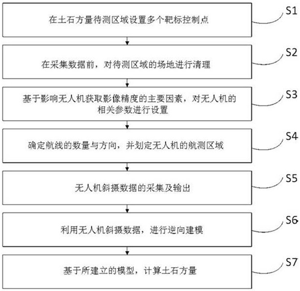
[0029] Such as figure 1 As shown, the earth and rock measurement method based on the UAV inverse modeling technology in the preferred embodiment of the present invention includes the following steps: Step S1. Setting multiple target control points in the area to be measured for earth and rock; Step S2. Before collecting data , to clean up the site in the area to be measured; Step S3. Based on the main factors affecting the accuracy of the image acquired by the UAV, set the relevant parameters of the UAV, wherein the main factors affecting the accuracy of the image acquired by the UAV include the route, relative Flight height and overlap; Step S4. Deter...


PUM


Abstract

The invention discloses an earth-rock volume measuring and calculating method based on an unmanned aerial vehicle inverse modeling technology. The earth-rock volume measuring and calculating method comprises the following steps: S1, setting a plurality of target control points in an earth-rock volume to-be-measured area; S2, cleaning the site of the to-be-detected area before data acquisition; S3, setting related parameters of the unmanned aerial vehicle based on main factors influencing the image acquisition precision of the unmanned aerial vehicle, wherein the main factors influencing the image acquisition precision of the unmanned aerial vehicle comprise an air route, a relative flight height and an overlapping degree; S4, determining the number and direction of air routes, and delimiting an aerial survey area of the unmanned aerial vehicle; S5, acquiring and outputting oblique shooting data of the unmanned aerial vehicle; S6, performing reverse modeling by using the oblique shooting data of the unmanned aerial vehicle; and S7, based on the established model, calculating the earth-rock volume.

Description

technical field [0001] The invention relates to the technical field of earth-rock volume measurement and calculation, in particular to an earth-rock volume measurement and calculation method based on unmanned aerial vehicle inverse modeling technology. Background technique [0002] Traditional methods of earthwork measurement and calculation, such as grid, scatter method, and table method, are often limited by measurement tools and terrain, and the RTK (Real-time kinematic, real-time dynamic) carrier phase difference technology introduced in recent years is also expensive due to equipment , Strong professionalism and cannot be applied to project engineering at any time. Therefore, the earth and stone measurement method in the prior art has the following disadvantages: ① depends on the manual operation of surveyors, and field surveying and mapping cannot guarantee the safety of surveying and mapping personnel; ②RTK equipment is expensive and professional, and cannot be applie...

Claims


Application Information

Patent Timeline
Patent Type & Authority Applications(China)
IPC IPC(8): G06F30/20G06T17/05G01D21/02
CPCG06F30/20G06T17/05G01D21/02
Inventor 陈泽鑫李伟陈俊宝卢浩然梁柏之何颜圻邓莉兰谢建祥杨肖刘骁张槐财廖良雄朱元张燕明
Owner CHINA CONSTR FIRST BUILDING GRP CORP LTD
Learn More