
Trajectory directional angle calculation method and system for earth attitude maneuvering scanning of remote sensing satellite

A technology of scanning trajectory and attitude maneuvering, which is applied in the field of satellite ground scanning analysis, can solve the problem that the attitude control system is difficult to realize scanning maneuvering, and achieve the effect of evaluating the rationality

Active Publication Date: 2021-06-15
SHANGHAI SATELLITE ENG INST
View PDF8 Cites 2 Cited by
  • Summary
  • Abstract
  • Description
  • Claims
  • Application Information

AI Technical Summary

Problems solved by technology

The scanning is realized by the attitude maneuver of the platform, so when the ground scanning trajectory is unreasonable, the attitude control capability will be too high, and the attitude control system is difficult to realize the scanning maneuver

Method used


Image

  • Trajectory directional angle calculation method and system for earth attitude maneuvering scanning of remote sensing satellite
  • Trajectory directional angle calculation method and system for earth attitude maneuvering scanning of remote sensing satellite
  • Trajectory directional angle calculation method and system for earth attitude maneuvering scanning of remote sensing satellite

Examples


Embodiment Construction

[0046] The present invention will be described in detail below in conjunction with specific embodiments. The following examples will help those skilled in the art to further understand the present invention, but do not limit the present invention in any form. It should be noted that those skilled in the art can make several changes and improvements without departing from the concept of the present invention. These all belong to the protection scope of the present invention.

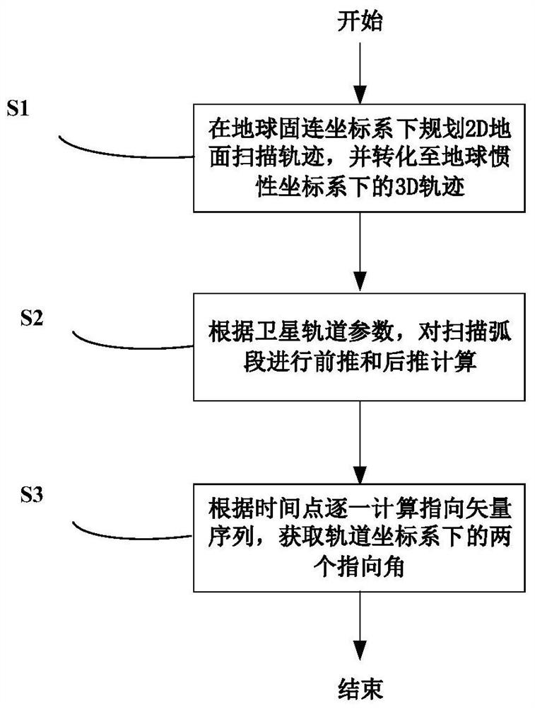
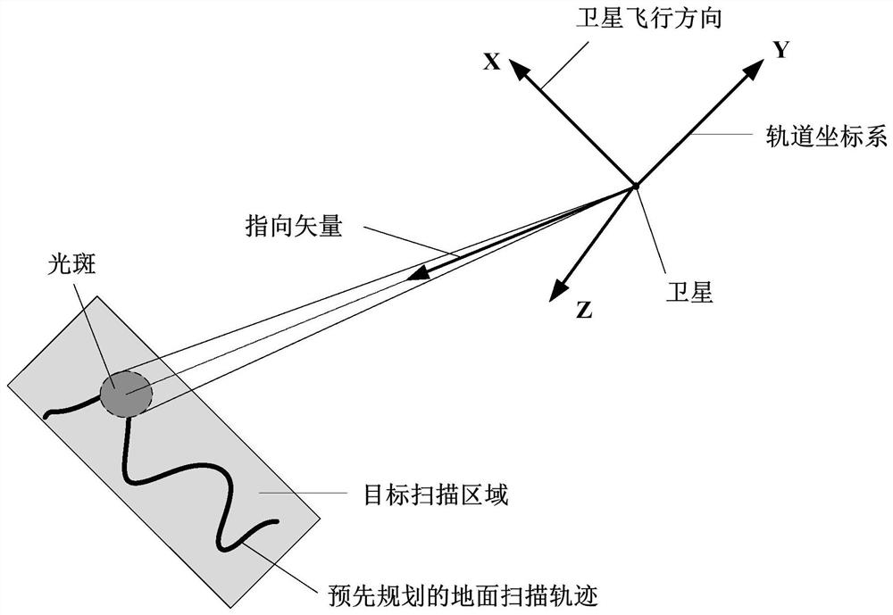
[0047] An embodiment of the present invention provides a method for calculating the trajectory pointing angle of a remote sensing satellite's maneuvering scan of the ground attitude, such as figure 1 with figure 2 As shown, firstly, the 2D ground scanning trajectory is planned in the earth’s fixed coordinate system, and the 2D ground scanning trajectory is transformed into the 3D scanning trajectory in the earth’s inertial coordinate system, as follows:

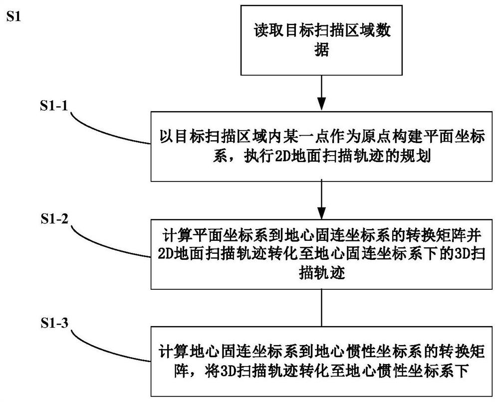
[0048] Such as figure 1 with image 3 As sho...


PUM


Abstract

The invention provides a trajectory directional angle calculation method and system for earth attitude maneuvering scanning of a remote sensing satellite, and relates to the technical field of satellite earth scanning analysis, and the method comprises the steps: S1, planning a 2D ground scanning trajectory under an earth fixed coordinate system, and converting the 2D ground scanning trajectory into a 3D scanning trajectory under an earth inertial coordinate system; S2, according to the satellite orbit parameters, performing forward and backward pushing calculation on the scanning arc section of the 3D scanning trajectory to obtain satellite orbit data; and S3, calculating pointing vector sequences one by one according to time points through satellite orbit data and a 3D scanning trajectory, and obtaining two pointing angles under an orbit coordinate system. According to the method, conversion from the ground scanning track to the directional angle can be executed, design input is provided for attitude control system design, and the reasonability of ground scanning track planning is evaluated.

Description

technical field [0001] The invention relates to the technical field of satellite-to-earth scanning analysis, in particular to a method and a system for calculating a trajectory pointing angle of a remote sensing satellite's ground attitude maneuver scanning. Background technique [0002] As modern situational awareness tends to be intelligent, satellites are required to have the ability to scan the target area once or even multiple times in one transit, which brings many technical challenges to the satellite platform design. In particular, in order to ensure the comprehensive performance of the load, it is often required that the ground scanning is realized by the attitude maneuver of the platform, while the load is fixed on the platform, which brings about the strong coupling of the attitude control system, orbit and scanning scheme design, which requires in-depth research. Analysis, through multiple iterations to finalize the design. The scanning is realized by the attitu...

Claims


Application Information

Patent Timeline
Patent Type & Authority Applications(China)
IPC IPC(8): G06F30/20
CPCG06F30/20Y02A90/10
Inventor 郑艺裕杨燕周世宏赖京陈华周必磊易灵
Owner SHANGHAI SATELLITE ENG INST
Learn More