Specific biological population elevation acquisition method based on digital elevation model

A digital elevation model and acquisition method technology, applied in 3D modeling, image data processing, complex mathematical operations, etc., can solve problems such as inability to obtain elevation data

Pending Publication Date: 2020-11-17
江西省寄生虫病防治研究所
View PDF0 Cites 4 Cited by
  • Summary
  • Abstract
  • Description
  • Claims
  • Application Information

AI Technical Summary

Problems solved by technology

High-resolution remote sensing and radar technology can quickly and efficiently obtain the elevation status information of a specific biological population in the ecological environment, but it is still unable to obtain accurate elevation data; GE data is highly accurate and is constantly being updated, but the elevation displayed by the original data Values ​​are World Geodetic System 1984 Coordinate System (WGS-84), not the 1985 Yellow Sea Elevation System commonly used in China

Method used


Image

  • Specific biological population elevation acquisition method based on digital elevation model
  • Specific biological population elevation acquisition method based on digital elevation model
  • Specific biological population elevation acquisition method based on digital elevation model

Examples


Embodiment Construction

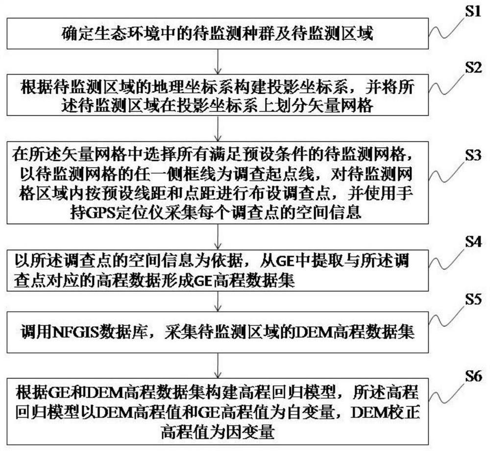
[0028] The technical problems, technical solutions and advantages of the present invention will be explained in detail below by referring to exemplary embodiments. The exemplary embodiments described below are only for explaining the present invention, but not construed as limiting the present invention. Those skilled in the art can understand that, unless otherwise defined, all terms (including technical and scientific terms) used herein have the same meaning as commonly understood by one of ordinary skill in the art to which this invention belongs. It should also be understood that terms such as those defined in commonly used dictionaries should be understood to have meanings consistent with their meaning in the context of the prior art and will not be used in an idealized or overly formal sense unless defined herein to explain.

[0029] The embodiment of the present invention proposes a method for obtaining the elevation of a specific biological population based on a digit...


PUM


Abstract

The invention discloses a specific biological population elevation acquisition method based on a digital elevation model (DEM), which is used for solving the problem of low precision of biological population elevation data in the prior art. The method comprises the following steps: after determining a to-be-monitored population and area, constructing a geographic coordinate system and a projectioncoordinate system, dividing vector grids, selecting a to-be-monitored grid meeting a preset condition, laying survey points by taking any one side frame line of the to-be-monitored grid as a startingpoint, and extracting GE elevation data sets corresponding to the survey points from GE; calling an NFGIS database, and collecting a DEM elevation data set; and constructing an elevation regression model according to the GE and DEM elevation data set, and obtaining a DEM correction elevation value. Real-time biological elevation data is collected based on DEM, the DEM data is corrected through GE, elevation distribution changes of specific biological populations are accurately monitored, and an accurate and reliable data source is provided for disease and pest control, environmental evaluation and environmental protection strategy making of the ecological environment.

Description

technical field [0001] The invention belongs to the field of ecological environment state monitoring and information processing, and in particular relates to a method for obtaining the elevation of a specific biological population based on a digital elevation model. Background technique [0002] Normally, the ecological environment is a relatively stable whole. In a period of time, its ecological distribution will be based on a stable state, especially for different elevations in the environment, different biological populations will be vertically distributed stably. At the same time, Corresponding plant populations will also correspond to corresponding animal populations. For example, Mount Kilimanjaro in Africa is vertically distributed as tropical rainforest, savannah, evergreen leaf forest, deciduous maple forest, alpine meadow, alpine desert, and snow-covered glacier. The corresponding animal biota is distributed on the plant biota. The stability of the distribution d...

Claims


Application Information

Patent Timeline
Patent Type & Authority Applications(China)
IPC IPC(8): G06F16/29G06F17/18G06T17/20G06F30/20
CPCG06F17/18G06T17/205G06F16/29G06F30/20
Inventor 胡飞林丹丹刘影卢成芳
Owner 江西省寄生虫病防治研究所
Why Eureka
Try Eureka