A Sub-satellite Point Surface Attribute Prediction Method Based on Surface Model Diagram

A surface model and sub-satellite point technology, applied in the field of spacecraft, can solve problems such as inability to judge surface attributes, large data storage capacity, and advanced search algorithms, so as to improve autonomous mission planning capabilities, improve accuracy, and reduce the number of longitude strips Effect

Active Publication Date: 2022-03-04
BEIJING INST OF CONTROL ENG
View PDF7 Cites 0 Cited by
  • Summary
  • Abstract
  • Description
  • Claims
  • Application Information

AI Technical Summary

Problems solved by technology

This method has a large amount of data storage, and the search algorithm has high requirements for software calculations, and the current DEM digital elevation model has no data at latitudes greater than 80 degrees, so it is impossible to accurately judge the surface properties

Method used


Image

  • A Sub-satellite Point Surface Attribute Prediction Method Based on Surface Model Diagram
  • A Sub-satellite Point Surface Attribute Prediction Method Based on Surface Model Diagram

Examples


Embodiment

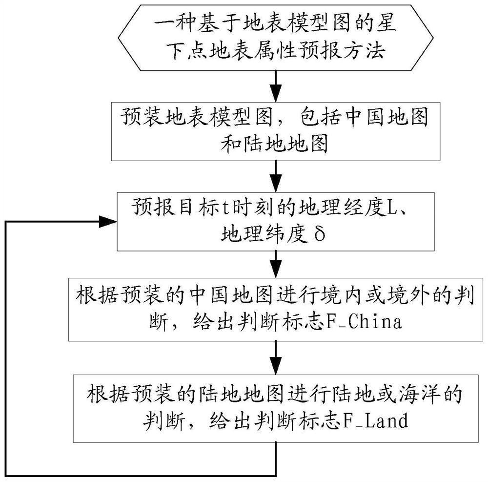
[0041] A sub-satellite point surface attribute prediction method based on the surface model diagram, the specific implementation steps are as follows, as figure 1 Shown:

[0042] 1) First pre-install the surface model map, including China map and land map.

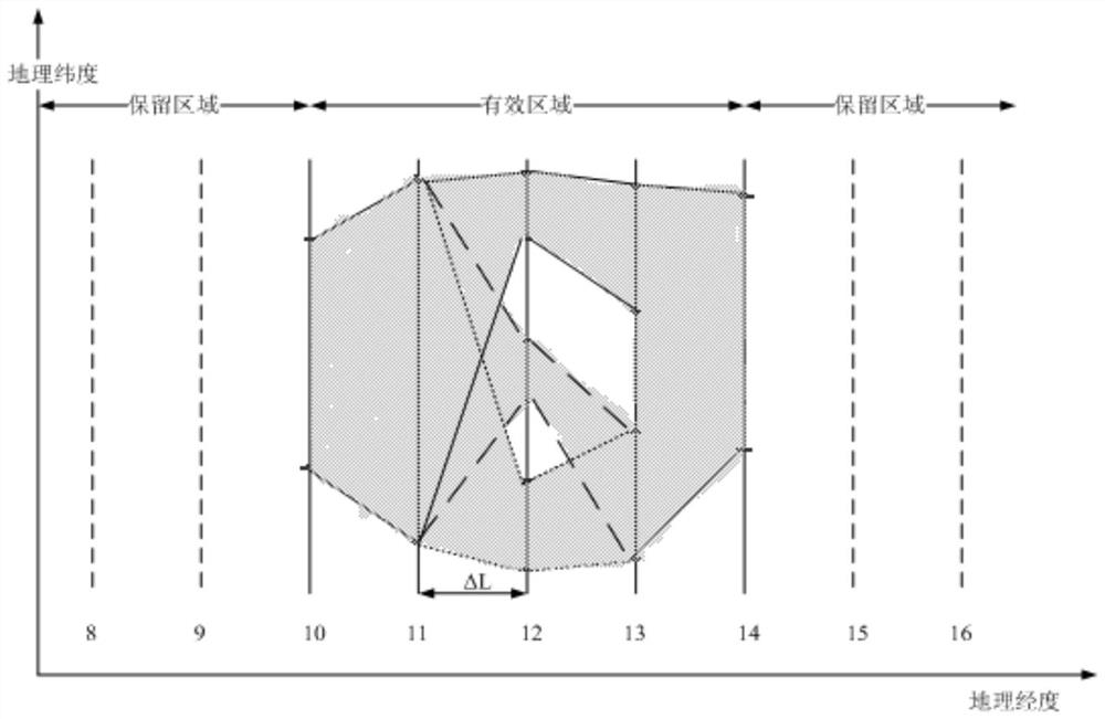
[0043] Step1: Divide the Chinese map and the land surface model map of each part of the world into many longitude strips with equal longitude intervals ΔL, and mark the upper limit and lower limit of the geographic latitude of the effective area on each longitude strip.

[0044] Step2: Preload the maps of each part according to the boundary information of the surface model. Preload the one-dimensional array Lon_i representing the longitude strip of the i-th region, the one-dimensional array LatMin_i representing the lower limit of the i-th region's latitude, and the one-dimensional array LatMax_i representing the upper limit of the i-th region's latitude. For areas with complex surface, the same longitude boundary point ...


PUM


Abstract

A method for predicting surface properties of sub-satellite points based on a surface model map, which belongs to the field of spacecraft attitude control. First, the surface model map is pre-installed, and the surface model map uses equidistant longitude strips, and each strip gives the strip area The upper and lower limits of the geographical latitude of "domestic or land" are used to simplify the surface positioning algorithm on the satellite. Secondly, the satellite independently predicts the geographic longitude L and geographic latitude δ of the sub-satellite point at time t of the target. Finally, the domestic or overseas forecast is performed according to the pre-installed map of China, and the land or ocean forecast is performed according to the pre-installed land map. The method of the invention solves the problems that the data storage capacity of the DEM digital elevation model is large and the search algorithm has high requirements for software calculation.

Description

technical field [0001] The invention relates to a sub-satellite point surface attribute prediction method based on a surface model diagram, belongs to the field of spacecraft attitude control, and is suitable for spacecraft with sub-satellite point attribute prediction requirements. Background technique [0002] For the prediction of surface properties, especially the prediction of land / ocean, the current existing methods generally store the DEM digital elevation model on the satellite, and judge whether it is land or ocean according to the elevation of the sub-satellite point. This method has a large amount of data storage, and the search algorithm has high requirements for software calculations, and the current DEM digital elevation model has no data at latitudes greater than 80 degrees, and cannot accurately judge surface attributes. Contents of the invention [0003] The technical problem to be solved by the present invention is to overcome the deficiencies of the prio...

Claims


Application Information

Patent Timeline
Patent Type & Authority Patents(China)
IPC IPC(8): G01C21/04G01S19/42
CPCG01C21/04G01S19/42
Inventor 刘洁黄缙莫凡田科丰王淑一周剑敏陈超程莉杨晓龙刘彤
Owner BEIJING INST OF CONTROL ENG
Why Eureka
Try Eureka