
GPS multi-satellite fusion soil humidity monitoring method based on fuzzy entropy

A soil moisture and fuzzy entropy technology, applied in measurement devices, using microwaves to test moisture content, instruments, etc., can solve the problems of data source limitations, not considering the difference and complementarity of satellite data, and achieve the effect of improving the inversion effect.

Pending Publication Date: 2020-06-26
山东航向电子科技有限公司
View PDF8 Cites 2 Cited by
  • Summary
  • Abstract
  • Description
  • Claims
  • Application Information

AI Technical Summary

Problems solved by technology

However, this method only uses the signal-to-noise ratio data of a single GNSS satellite in a single frequency band, and does not consider the differences and complementarities of satellite data of different orbits, frequencies, and powers, and the data source is also greatly limited.

Method used


Image

  • GPS multi-satellite fusion soil humidity monitoring method based on fuzzy entropy
  • GPS multi-satellite fusion soil humidity monitoring method based on fuzzy entropy
  • GPS multi-satellite fusion soil humidity monitoring method based on fuzzy entropy

Examples


Embodiment 1

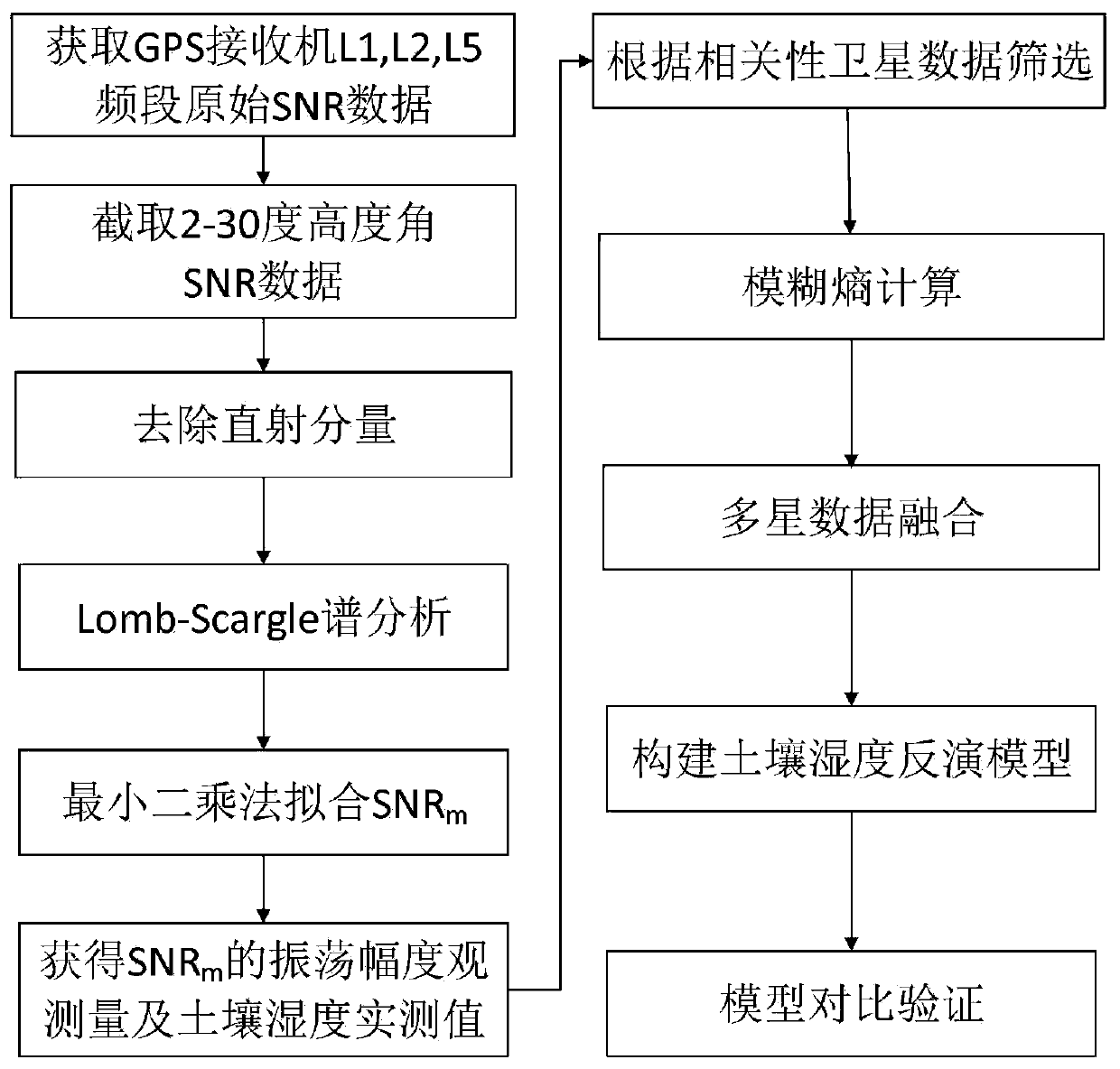
[0056] Such as figure 2 Shown, the GPS multi-satellite fusion soil moisture monitoring method based on fuzzy entropy of the present invention, comprises the following steps:

[0057] Step 1: Data Acquisition

[0058]Set up GPS receivers and antennas on the experimental site, and set up automatic weather station equipment to collect year-on-year soil moisture measurements and store them in RINEX format.

[0059] Step 2: Data Filtering

[0060] Extract the SNR, elevation angle, azimuth angle, and time of L1, L2, and L5 from the collected data according to the PRN, conduct preliminary screening on the extracted data, and eliminate the data whose SNR oscillation is not obvious.

[0061] Step 3: Data Preprocessing

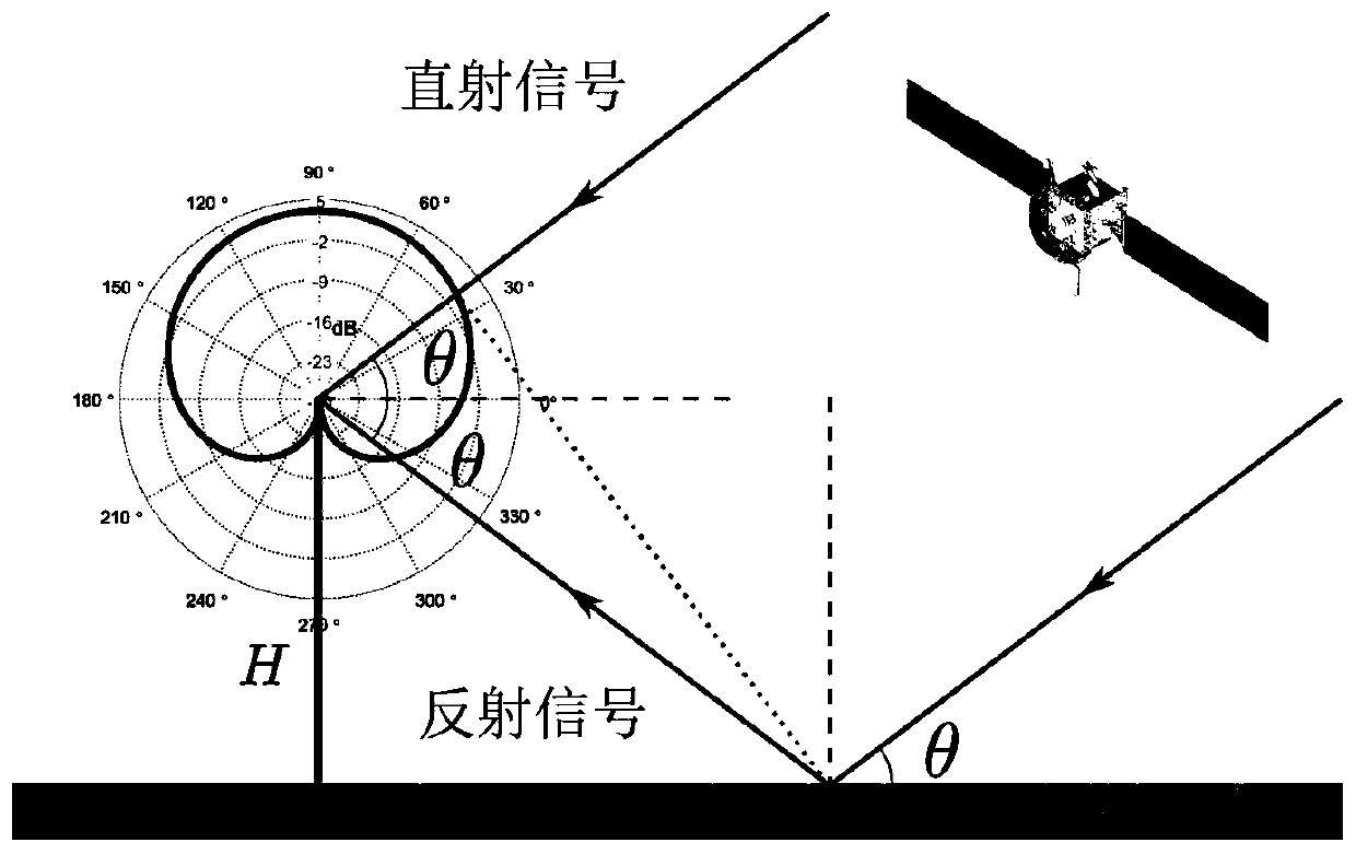
[0062] Such as figure 1 As shown, the SNR of direct and reflected signals can be expressed as:

[0063]

[0064] In the formula, A d 、A m Respectively represent the amplitude of the direct and reflected signals, and ψ represents the phase difference between t...


PUM


Abstract

The invention discloses a GPS multi-satellite fusion soil humidity monitoring method based on fuzzy entropy, and belongs to the technical field of soil humidity measurement. The method comprises the steps: extracting oscillation amplitudes of signal-to-noise ratios of three frequency bands of all satellites from a GPS receiver by using the GNSS-IR technology, performing fusion by using a fuzzy entropy method to obtain an optimal multi-satellite three-frequency oscillation amplitude fusion value, and establishing an inversion model with soil humidity by using the fusion value. According to themethod, the difference and complementarity of GPS multi-satellite three-frequency data are effectively utilized, and the inversion effect is obviously improved compared with that of a single-satellitesingle-frequency method; and the problems in the prior art are solved.

Description

technical field [0001] The invention relates to a GPS multi-satellite fusion soil moisture monitoring method based on fuzzy entropy, which belongs to the technical field of soil moisture measurement. Background technique [0002] Soil moisture is an important link in the global carbon-water cycle and a key parameter to quantify the energy exchange between land and atmosphere. Timely and accurate acquisition of farmland soil moisture data is very important for rational irrigation in agricultural production, reducing water waste, reducing production costs and increasing crop yields. Compared with the traditional drying and weighing method, time domain reflectometry (TDR), frequency domain reflectometry (FDR) and other contact methods to obtain soil moisture, using GNSS-R (Global Navigation Satellite System Reflectometry, GNSS-R) technology Soil moisture detection is an emerging technical method, which has the advantages of non-contact, large area, real-time and continuity, an...

Claims


Application Information

Patent Timeline
IPC IPC(8): G01N27/22G01N22/04
CPCG01N27/223G01N27/221G01N22/04
Inventor 杨东凯孙波常海宁岳宪雷
Owner 山东航向电子科技有限公司
Learn More