Building-level AP crowdsourcing generation method

A building and crowdsourcing technology, applied in the field of positioning, can solve problems such as large labor consumption, and achieve the effect of reducing the cost of building and updating the database

Active Publication Date: 2019-12-03
BEIJING RTMAP TECH
View PDF8 Cites 0 Cited by
  • Summary
  • Abstract
  • Description
  • Claims
  • Application Information

AI Technical Summary

Problems solved by technology

[0003] WiFi positioning is currently the mainstream indoor positioning method. The establishment and maintenance of location fingerprint database is very important for WiFi positioning. However, this method uses professionals to create and update fingerprints, which consumes a lot of manpower.

Method used


Image

  • Building-level AP crowdsourcing generation method
  • Building-level AP crowdsourcing generation method

Examples


Embodiment Construction

[0019] The technical solution of this patent will be further described in detail below in conjunction with specific embodiments.

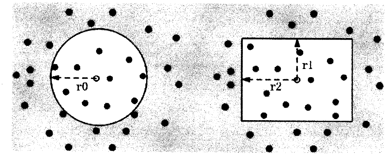
[0020] see Figure 1-2 , a method for building-level AP crowdsourcing generation, the specific steps are as follows:

[0021] Step 1: Obtain the center coordinates of the building and convert them into coordinates in the WGS84 coordinate system, such as x0 and y0;

[0022] Step 2, estimate the radius r0 of the building, or r1, r2 (rectangle), or other shapes;

[0023] Step 3, use the crowdsourced log to filter with the center point and radius to obtain the log that falls around the building;

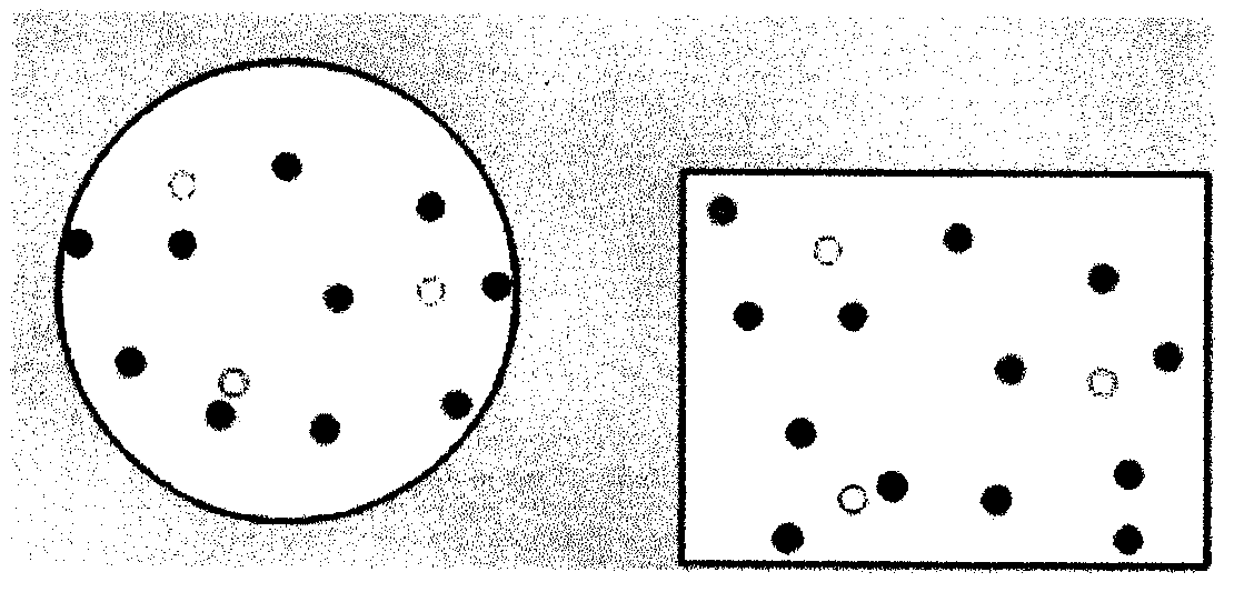
[0024] Step 4, clustering the obtained logs according to the similarity of fingerprints to obtain topN (N>=1) categories, figure 2 The solid dots of the same color represent the same class, and the hollow dots of the corresponding color represent the center of the class;

[0025] Step 5, obtain the center AP {mac / rssi / channel / ssid} in each category, the ...


PUM


Abstract

The invention discloses a building-level AP crowdsourcing generation method. The method comprises specific steps of first, acquiring center coordinates of a building, and converting the center coordinates into coordinates in a WGS84 coordinate system; second, estimating a radius r0 of the building, or r1 and r2 (rectangle), or other shapes; third, filtering based on a center point and a radius byusing crowdsourcing log, and acquiring log surrounding the building; fourth, clustering obtained log according to fingerprint similarity, so as to obtain topN categories, wherein N is greater than orequal to 1; fifth, acquiring a center AP of each category; sixth, acquiring AP in some buildings; and seventh, snowballing to obtain AP in other fields by using data of the third step according to a co-occurrence relation with the AP acquired in the sixth step as a primer. When meeting the demand of positioning accuracy, the method establishes a building-level AP characteristic database by analyzing and processing crowdsourcing data, thereby effectively lowering overhead for database establishment and updating.

Description

technical field [0001] The invention relates to the field of positioning, in particular to a method for building-level AP crowdsourcing generation. Background technique [0002] Positioning is a Chinese vocabulary, which means to determine the orientation, to determine or point out the place, to determine the place or boundary (such as through survey) to locate the boundary of this property. There are many positioning methods. GPS positioning and WiFi positioning are common positioning methods. GPS is a technology that combines satellite and communication development, and uses navigation satellites for time measurement and distance measurement. GPS was developed by the United States in the 1970s. It took more than 20 years and cost 20 billion U.S. dollars. It was fully completed in 1994. A new generation of satellite navigation and positioning system with all-round real-time three-dimensional navigation and positioning capabilities in land, sea and air. After nearly ten ye...

Claims


Application Information

Patent Timeline
Patent Type & Authority Applications(China)
IPC IPC(8): G01C21/20G06K9/62
CPCG01C21/206G06F18/23Y02D30/70
Inventor 王文杰方灵刘文龙徐连明
Owner BEIJING RTMAP TECH
Why Eureka
Try Eureka