
Quantitative inversion method of aboveground vegetation ecological water based on remote sensing technology

A remote sensing technology and vegetation technology, applied in the direction of neural learning methods, biological neural network models, instruments, etc., can solve the problems of inaccurate ecological water content of vegetation, and does not consider the information of plant structure parameters, so as to improve the accuracy and accuracy of remote sensing inversion. High performance, solve the effect that is difficult to quantify

Active Publication Date: 2020-05-05
CHENGDU UNIVERSITY OF TECHNOLOGY
View PDF8 Cites 0 Cited by
  • Summary
  • Abstract
  • Description
  • Claims
  • Application Information

AI Technical Summary

Problems solved by technology

[0007] The technical problem to be solved by the present invention is: the existing vegetation ecological water estimation only considers the information of the surface layer of the vegetation canopy, and does not consider the structural parameter information of the plants, which leads to inaccurate vegetation ecological water content inversion

Method used


Image

  • Quantitative inversion method of aboveground vegetation ecological water based on remote sensing technology
  • Quantitative inversion method of aboveground vegetation ecological water based on remote sensing technology
  • Quantitative inversion method of aboveground vegetation ecological water based on remote sensing technology

Examples


Embodiment Construction

[0043] In order to make the purpose, technical solutions and advantages of the present invention clearer, the present invention will be further described in detail below in conjunction with the examples and accompanying drawings. As a limitation of the present invention.

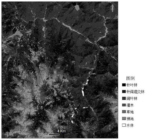
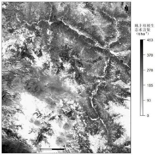
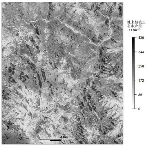
[0044] In this embodiment, local areas of the western Sichuan plateau are taken as an example, and according to the technical solution of the present invention, the calculation formula of vegetation ecological water is combined. Using multi-temporal multi-spectral remote sensing and microwave remote sensing (SAR) technology to invert the ecological water content of different types of plants on the ground, the steps are as follows:

[0045] Step 1: Scientifically select the research area and delineate the sample plot.

[0046] In this example, a part of the Western Sichuan Plateau is selected as the research area, and the sample area is a sample circle with a radius of 5 meters.

[0047] Step 2: Field data ...


PUM


Abstract

The invention discloses a quantitative inversion method for aboveground vegetation ecological water based on remote sensing technology. The invention is based on Sentinel 2A optical remote sensing images and Sentinel 1A microwave remote sensing images, and adopts BP artificial neural network model to invert the aboveground vegetation ecological water in local areas of the western Sichuan plateau to solve the problem of The existing aboveground vegetation ecological water inversion only considers the information of the surface of the vegetation canopy, but does not consider the information of the structural parameters of the plants, which leads to the inaccurate scientific problem of the inversion of vegetation ecological water content. The results show that the method based on biomass The calculation method of aboveground vegetation ecological water is scientific and accurate. The invention mainly uses the biomass method to scientifically study the ecological water content of aboveground vegetation, including field data collection, calculation of moisture content and biomass, calculation of ecological water of aboveground vegetation, modeling and inversion of ecological water content in the research area according to the BP artificial neural prediction model.

Description

technical field [0001] The invention relates to the technical field of ecological water quantitative research, in particular to a method for quantitative inversion of aboveground vegetation ecological water based on remote sensing technology. Background technique [0002] Ecological water (layer) is essentially different from concepts such as "ecological water demand" and "biological water" in general literature. Ecological water (layer) refers to the relationship between surface vegetation (including stem layer of vegetation leaf surface, root soil layer and humus layer). It is a water storage body closely related to precipitation, which can buffer, distribute and regulate precipitation. It is an important link in the hydrological cycle, and it is also a research hotspot and difficulty. [0003] Vegetation water content is an important part of ecological water (layer). Since traditional remote sensing techniques used to estimate vegetation water content are mostly based on ...

Claims


Application Information

Patent Timeline
Patent Type & Authority Patents(China)
IPC IPC(8): G06K9/00G06N3/08
CPCG06N3/084G06V20/188
Inventor 杨武年雷俊杰杨鑫巫明焱佘金星周湘山苏悦
Owner CHENGDU UNIVERSITY OF TECHNOLOGY
Learn More