UWB (Ultra Wideband) positioning method and system for automatic navigation and positioning of agricultural working machine

A technology for operating machinery and automatic navigation, applied in satellite radio beacon positioning systems, radio wave measurement systems, measurement devices, etc., can solve the problem of low navigation and positioning accuracy

Active Publication Date: 2019-08-16
HUNAN AGRICULTURAL UNIV
View PDF6 Cites 10 Cited by
  • Summary
  • Abstract
  • Description
  • Claims
  • Application Information

AI Technical Summary

Problems solved by technology

[0003] The invention provides a UWB positioning method and system for automatic navigation and positioning of agricultural operation machinery, which solves the technical problem of low accuracy of automatic navigation and positioning of existing agricultural operation machinery

Method used


Image

  • UWB (Ultra Wideband) positioning method and system for automatic navigation and positioning of agricultural working machine
  • UWB (Ultra Wideband) positioning method and system for automatic navigation and positioning of agricultural working machine
  • UWB (Ultra Wideband) positioning method and system for automatic navigation and positioning of agricultural working machine

Examples


Embodiment 1

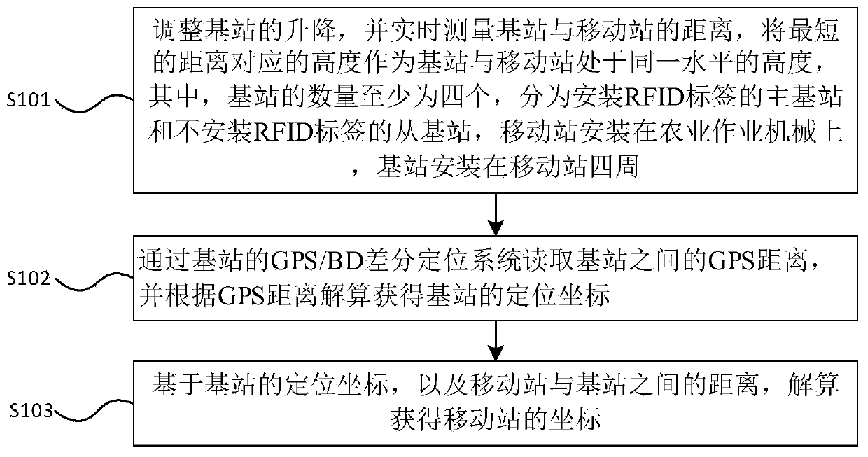
[0037] refer to figure 1 The UWB positioning method for automatic navigation and positioning of agricultural operating machinery provided by Embodiment 1 of the present invention includes:

[0038] Step S101, adjust the lifting of the base station, and measure the distance between the base station and the mobile station in real time, and use the height corresponding to the shortest distance as the height at the same level between the base station and the mobile station, wherein the number of base stations is at least four, divided into RFID installation The main base station of the tag and the slave base station without RFID tags, the mobile station is installed on the agricultural operation machinery, and the base station is installed around the mobile station;

[0039] Step S102, read the GPS distance between the base stations through the GPS / BD differential positioning system of the base station, and calculate and obtain the positioning coordinates of the base station accor...

Embodiment 2

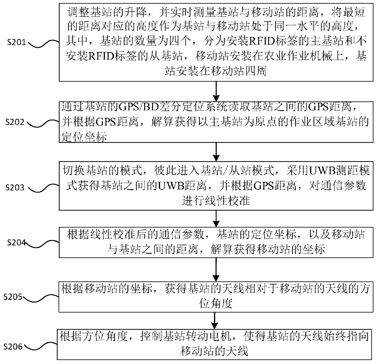
[0045] refer to figure 2 The UWB positioning method for automatic navigation and positioning of agricultural operating machinery provided by Embodiment 2 of the present invention includes:

[0046] Step S201, adjust the lifting of the base station, and measure the distance between the base station and the mobile station in real time, and use the height corresponding to the shortest distance as the height at the same level as the base station and the mobile station, where the number of base stations is four, which are divided into RFID tags installed The master base station and the slave base station without RFID tags, the mobile station is installed on the agricultural machinery, and the base station is installed around the mobile station.

[0047]Specifically, in this embodiment, fixed bases are installed at four corresponding positions in the field, and a corresponding RFID tag is installed on one of the four bases. The RFID tag in this embodiment is used to read the beacon...


PUM


Abstract

The invention discloses an UWB (Ultra Wideband) positioning method and system for automatic navigation and positioning of an agricultural working machine. The method comprises the following steps: adjusting the ascending and descending of a base station, measuring the distance between a base station and a mobile station in real time, and taking a height corresponding to a shortest distance as a height at which the base station and the mobile station are positioned at the same level; reading the GPS distance between base stations through a GPS / BD differential positioning system of the base station; and resolving the positioning coordinates of the base station according to the GPS distance, and resolving the coordinates of the mobile station according to the distance between the mobile station and the base station. Through adoption of the UWB positioning method and system, the technical problem of low automatic navigation and positioning accuracy in an existing agricultural working machine is solved. The base station is kept at the same horizontal plane according to the principle that the fixed point distance between the base station and the mobile station is shortest through the level change of the base station, so that the positioning coordinates of the base stations in the working areas on the same horizontal plane can be obtained accurately, and high-accuracy coordinates of the mobile station can be resolved rapidly.

Description

technical field [0001] The invention relates to the technical field of navigation and positioning of farmland operation machinery, in particular to a UWB (Ultra Wideband, ultra-wideband) positioning method and system for automatic navigation and positioning of agricultural operation machinery. Background technique [0002] In terms of navigation and positioning technology for farmland operation machinery, geomagnetic pre-embedding, GPS (Global Positioning System, Global Positioning System) positioning, and laser navigation and positioning are usually used. Accurate and cost-effective navigation and positioning, especially the navigation and positioning of small fields, has always been the focus of research. The existing geomagnetic pre-embedded construction and later use costs are relatively high, and the GPS positioning system is costly and greatly affected by the environment (antennas, leaves, etc.) etc.), resulting in low positioning accuracy of automatic navigation. Co...

Claims


Application Information

Patent Timeline
Patent Type & Authority Applications(China)
IPC IPC(8): G01S19/46
CPCG01S19/46Y02D30/70
Inventor 蒋蘋胡文武罗亚辉石毅新王奕黄腾达
Owner HUNAN AGRICULTURAL UNIV
Why Eureka
Try Eureka