Complete set of equipment and surveying and mapping method for 3D laser scanner applied to faro software

A technology of three-dimensional laser and complete equipment, which is applied in the directions of surveying, mapping and navigation, using optical devices, active optical measuring devices, etc., can solve the problems that the three-dimensional maps cannot be completely overlapped, are not accurate enough, and work is inconvenient, and achieve the goal of improving accuracy and surveying and mapping The effect of accuracy

Active Publication Date: 2021-02-05
南京龙测测绘技术有限公司
View PDF7 Cites 1 Cited by
  • Summary
  • Abstract
  • Description
  • Claims
  • Application Information

AI Technical Summary

Problems solved by technology

However, when the axial direction of the scanner and the ring is staggered, the ring becomes an ellipse during the imaging process. At this time, the coordinate table for measuring the center of the ring will not be accurate enough, resulting in the integration of multiple three-dimensional images. Sometimes, the different 3D images cannot be completely overlapped, which brings inconvenience to the follow-up work

Method used


Image

  • Complete set of equipment and surveying and mapping method for 3D laser scanner applied to faro software
  • Complete set of equipment and surveying and mapping method for 3D laser scanner applied to faro software
  • Complete set of equipment and surveying and mapping method for 3D laser scanner applied to faro software

Examples


Embodiment 1

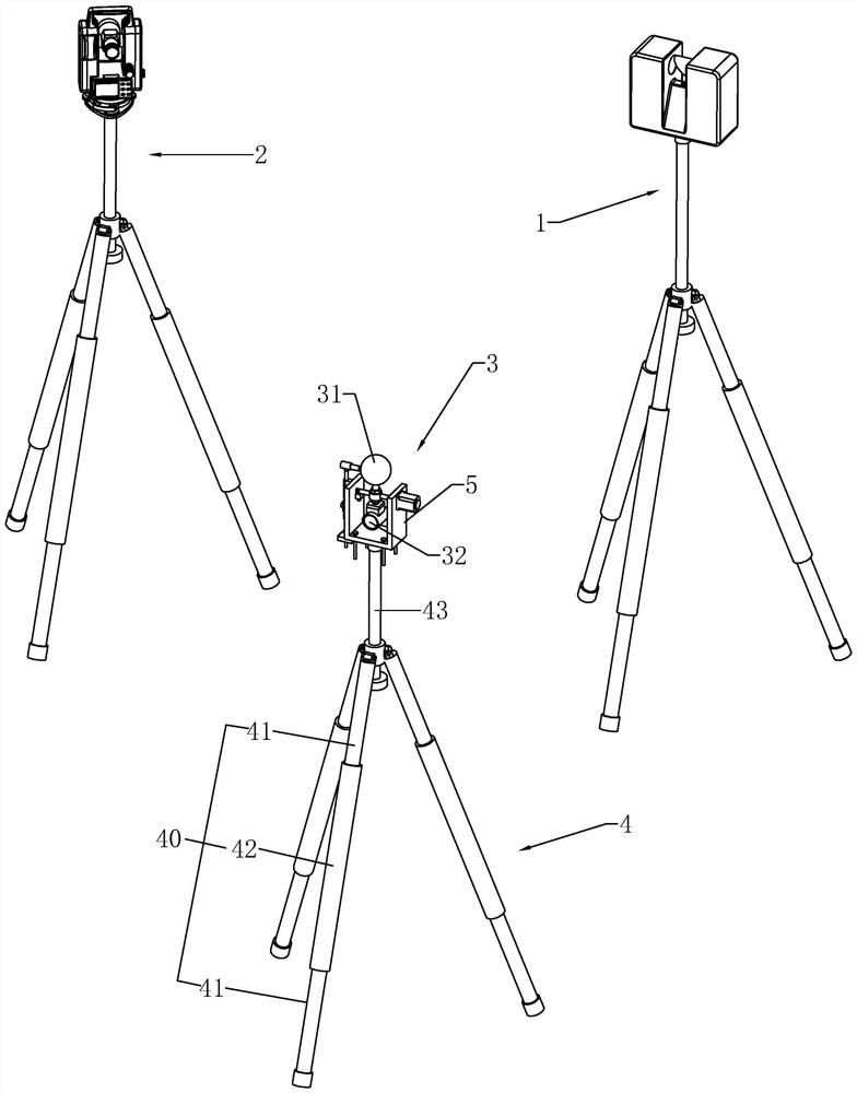
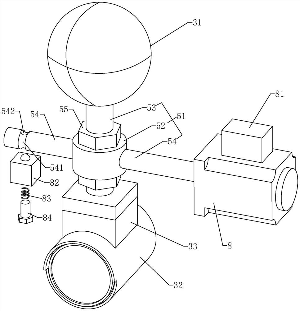
[0044] Example 1: Reference figure 1 and figure 2 , a complete set of three-dimensional laser scanner equipment applied to FARO software, comprising a three-dimensional laser scanner 1, a total station 2, and a coordinate transformation device 3. The coordinate conversion device 3 comprises a tripod 4, a U-shaped base 5 arranged on the tripod 4, and a connecting frame 51. The upper and lower ends of the connecting frame 51 are respectively provided with a reference ball 31 and a prism 32. When the connecting frame 51 rotates 180 degrees, the prism 32 The center of the sphere and the center of the reference sphere 31 will exchange positions. First coordinate conversion device 3 is placed on the surveying and mapping site, and reference ball 31 is arranged on the top, and prism 32 is arranged on the bottom; Then use three-dimensional laser scanner 1 to carry out multiple scans to the environment inside the workshop; when three-dimensional laser scanner 1 is surveying and mappi...


PUM


Abstract

The invention discloses a complete set of equipment and a surveying and mapping method for a three-dimensional laser scanner applied to FARO software. It is applied in the field of three-dimensional laser scanners and solves the technical problem of low scanning accuracy in the scanning process. The key points of the technical scheme include three-dimensional laser scanning instrument, a total station, and a coordinate conversion device, the coordinate conversion device includes a tripod, a U-shaped base connected to the tripod, the base is provided with a cross-shaped connecting frame, and the horizontal section of the connecting frame is rotatably connected to the On the base, the two sides of the vertical section of the connecting frame are respectively connected with a reference ball and a prism, and the midpoint of the line between the center of the reference ball and the center of the prism is located at the horizontal section of the connecting frame The axial direction; the technical effect is that it can more accurately present the environment inside the workshop in a three-dimensional way.

Description

technical field [0001] The invention relates to the field of three-dimensional laser scanners, more specifically, it relates to a complete set of three-dimensional laser scanner equipment and a surveying and mapping method applied to FARO software. Background technique [0002] Three-dimensional laser scanning technology is also called real scene replication technology. It uses high-speed laser scanning measurement method to quickly obtain three-dimensional coordinate data of the surface of the measured object in a large area and high resolution. It can quickly and massively collect spatial point information, providing a new technical means for quickly establishing a 3D image model of an object. [0003] The 3D imaging of the 3D laser scanner has a range. When the factory workshop is being transformed, multiple measurements are required. Each measurement will form a 3D map. Find a common coordinate in these 3D maps so that the 3D maps overlap. , so that a complete three-dim...

Claims


Application Information

Patent Timeline
Patent Type & Authority Patents(China)
IPC IPC(8): G01B11/24G01C15/00
CPCG01B11/24G01C15/002
Inventor 刘春雷
Owner 南京龙测测绘技术有限公司
Why Eureka
Try Eureka