
Remote sensing image missing data restoration method based on standard remote sensing image

A technology for remote sensing images and missing data, applied in image data processing, image enhancement, image analysis, etc., can solve the problems of spectral distortion, image spectral distortion, and low restoration accuracy.

Active Publication Date: 2019-06-25
LUDONG UNIVERSITY
View PDF31 Cites 7 Cited by
  • Summary
  • Abstract
  • Description
  • Claims
  • Application Information

AI Technical Summary

Problems solved by technology

[0004] The purpose of the present invention is to overcome the deficiency that the above-mentioned multi-remote sensing image filling method does not perform terrain-sensor-sun geometric correction on the reference image, and the spectrum between the two images is distorted. The remote sensing image missing data repair method of the image mainly solves the problem of spectral distortion between the two images caused by the traditional multi-remote sensing image filling method because it does not take into account the terrain-sensor-sun imaging geometry difference between the reference image and the image to be repaired. Obvious, so that the spectral distortion of the image after restoration is obvious, and it is difficult to be applied to the problem of quantitative remote sensing research

Method used


Image

  • Remote sensing image missing data restoration method based on standard remote sensing image

Examples


Embodiment 1

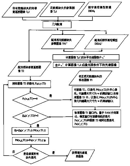
[0038] Example 1, see figure 1 , a method for repairing missing data in remote sensing images based on standard remote sensing images, comprising the following steps:

[0039] The first step is to obtain a reference remote sensing image T that covers the same area without missing data 0 1. Remote sensing image T to be repaired with missing data 0 2 and digital elevation model data DEM 0 ;

[0040] In the second step, the reference remote sensing image T with no missing data 0 1. Remote sensing image T to be repaired with missing data 0 2 and digital elevation model data DEM 0 Perform geometric registration to obtain a reference remote sensing image T with no missing data after registration 0 1'. Remote sensing image T2 to be repaired after registration and digital elevation model data DEM after registration 0 ';

[0041] In the third step, according to the reference remote sensing image T with no missing data 0 The solar zenith angle, azimuth angle parameters and digi...


PUM


Abstract

The invention discloses a remote sensing image missing data restoration method based on a standard remote sensing image, and the method is characterized in that the method comprises the steps: firstly, correcting a spectral value of a reference remote sensing image without missing data to a spectral value of a to-be-restored remote sensing image under an illumination condition, and constructing the standard remote sensing image; respectively constructing local windows by taking the missing data pixels in the remote sensing image to be repaired and the same coordinate pixels in the standard remote sensing image as centers; performing spectral classification in a standard remote sensing image window, and determining and recording the position (x, y) of a pixel most similar to the spectrum ofthe central pixel in the window and the ratio Ki of spectral values of the pixel to the central pixel on each waveband; in the window of the remote sensing image to be repaired, dividing the spectralvalue of the pixel at the same position (x, y) by Ki to fill the missing spectral value of the central pixel of the window. According to the method, the calculation amount is reduced, the influence of image spectral distortion caused by different sun illumination on the pixel classification precision is overcome, and the method has the advantages of being high in restoration precision and small in calculation amount.

Description

Technical field: [0001] The invention relates to the technical field of digital image restoration, in particular to a method for repairing missing data of remote sensing images based on standard remote sensing images, which is based on the stronger spectral correlation of remote sensing images of different time phases under the same terrain-sensor-sun geometric relationship Using the method of cosine terrain correction, correct the reference image without missing data to the spectral image under the terrain-sensor-sun imaging geometry of the remote sensing image to be repaired in the same area, construct a standard image, and based on the standard image, through the local window The pixel SAM classification technology determines the spectral value of the missing pixel in the remote sensing image to be repaired. This method can be used to repair the missing data of remote sensing images caused by sensor hardware, software or human faults. Background technique: [0002] Takin...

Claims


Application Information

Patent Timeline
Patent Type & Authority Applications(China)
IPC IPC(8): G06T5/00G06T7/33G06T7/507
Inventor 王露李雨桐宋媛杨智程周鑫侯杨王涛吴孟泉李国庆
Owner LUDONG UNIVERSITY
Learn More