Method of 3D Laser Scanner Applied to Deformation Monitoring of Foundation Pit

A three-dimensional laser, deformation monitoring technology, applied in the test of infrastructure, infrastructure engineering, construction, etc., can solve the problem of nonlinear, the deformation information of adjacent monitoring points cannot be known, etc., and achieve the effect of high efficiency

Active Publication Date: 2019-12-24
QINGDAO TECHNOLOGICAL UNIVERSITY
View PDF6 Cites 0 Cited by
  • Summary
  • Abstract
  • Description
  • Claims
  • Application Information

AI Technical Summary

Problems solved by technology

[0005] The technical problem to be solved in the present invention is to adopt theodolite and total station to observe, and there is following shortcoming: (1) monitoring point layout is generally every 20m to arrange a point, and this observation is single-point observation, and the data that monitoring obtains is isolated Point information, the deformation information between adjacent monitoring points cannot be known, and it is believed that the deformation between two adjacent monitoring points changes linearly, which is inconsistent with the reality. In fact, the deformation is nonlinear

Method used


Image

  • Method of 3D Laser Scanner Applied to Deformation Monitoring of Foundation Pit
  • Method of 3D Laser Scanner Applied to Deformation Monitoring of Foundation Pit
  • Method of 3D Laser Scanner Applied to Deformation Monitoring of Foundation Pit

Examples


Embodiment 1

[0054] A method for applying a three-dimensional laser scanner to foundation pit deformation monitoring, comprising the following steps:

[0055] 1. Acquisition of datum point cloud

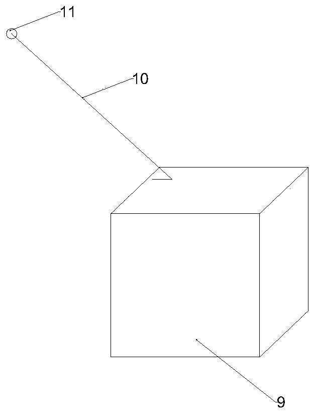
[0056] 1. Station reference point: the selection of station reference point 11 is as follows: figure 1 shown. A reference station is arranged outside the excavation range of twice the foundation pit excavation range of the 45° extension line 10 of the excavated foundation pit 9.

[0057] The advantages of doing this: (1) The 45° extension line of the inner corner of the foundation pit is relatively stable and will not be affected by the deformation caused by the excavation of the foundation pit; (2) Only one station needs to be selected to avoid the work caused by selecting multiple stations (3) Multiple measurements can be made on one reference station to avoid errors caused by distance and angle changes during focusing, centering, and observation, making the scanning accuracy higher.

[0058...


PUM


Abstract

The invention belongs to the technical field of underground engineering spatial position deformation informatization and particularly relates to a method for applying a 3D Laser Scanner to foundationpit deformation monitoring. By adopting the 3D Laser Scanner, continuous multi-point scanning and automatic data acquisition can be achieved, the data acquisition efficiency and precision are greatlyimproved, and the data acquisition amount is greatly increased. Obtained point cloud information solves a current situation of isolated points, and meanwhile, deformation information can be quickly captured; real-time information about large deformation can be captured, the deformation information is visualized, and the deformation condition of a foundation pit can be more visually displayed.

Description

technical field [0001] The invention belongs to the technical field of spatial position deformation of underground engineering, and in particular relates to a method for applying a three-dimensional laser scanner to monitoring deformation of foundation pits. Background technique [0002] According to the requirements of national regulations, deformation monitoring is required for foundation pits with a depth greater than 5m. Commonly used methods include the use of total stations and level equipment for horizontal displacement and settlement monitoring. When carrying out deformation monitoring, the control network is established through the control points, and then the deformation point monitoring is carried out. Using theodolite and total station for observation has the following disadvantages: (1) The layout of monitoring points is generally to arrange a point every 20m. It is impossible to know the deformation information between two adjacent monitoring points. It is be...

Claims


Application Information

Patent Timeline
Patent Type & Authority Patents(China)
IPC IPC(8): E02D33/00
Inventor 袁长丰陈秋汝王英汀于浩杰李亮于广明
Owner QINGDAO TECHNOLOGICAL UNIVERSITY
Why Eureka
Try Eureka