Highway Lane Line Detection Method Based on Line Spacing Feature Points Clustering in Aerial Video

A lane line detection and feature point technology, which is applied in the field of image processing and traffic video detection, can solve the problems of low accuracy, low detection speed, and inability to meet the needs of real-time detection, achieving accurate and more stable fitting effects, reducing The effect of small processing times

Active Publication Date: 2021-11-26
SOUTHEAST UNIV
View PDF4 Cites 0 Cited by
  • Summary
  • Abstract
  • Description
  • Claims
  • Application Information

AI Technical Summary

Problems solved by technology

However, the existing detection methods are either inaccurate or the detection speed is low, which cannot meet the needs of real-time detection.

Method used


Image

  • Highway Lane Line Detection Method Based on Line Spacing Feature Points Clustering in Aerial Video
  • Highway Lane Line Detection Method Based on Line Spacing Feature Points Clustering in Aerial Video
  • Highway Lane Line Detection Method Based on Line Spacing Feature Points Clustering in Aerial Video

Examples


Embodiment Construction

[0097] The technical solutions provided by the present invention will be described in detail below in conjunction with specific examples. It should be understood that the following specific embodiments are only used to illustrate the present invention and are not intended to limit the scope of the present invention.

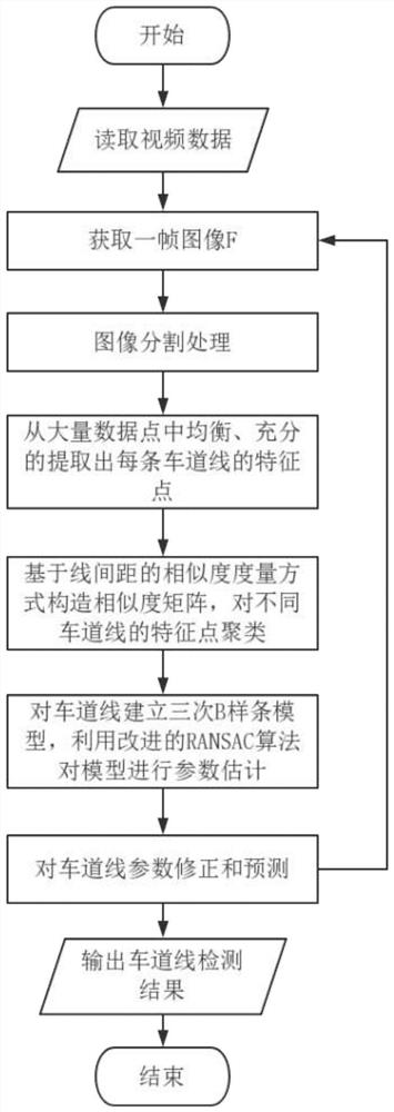
[0098] The present invention provides a method for detecting highway lane lines in aerial photography video based on line spacing feature point clustering, the process of which is as follows figure 1 shown, including the following steps:

[0099] Step 1: Read Video Frames

[0100] Read the video file from the drone's on-board camera to obtain a frame of color image F with the size of W×H×3, where W and H are positive integers, representing the width and height of the color image, respectively.

[0101] Step 2: image segmentation processing, including the following sub-steps:

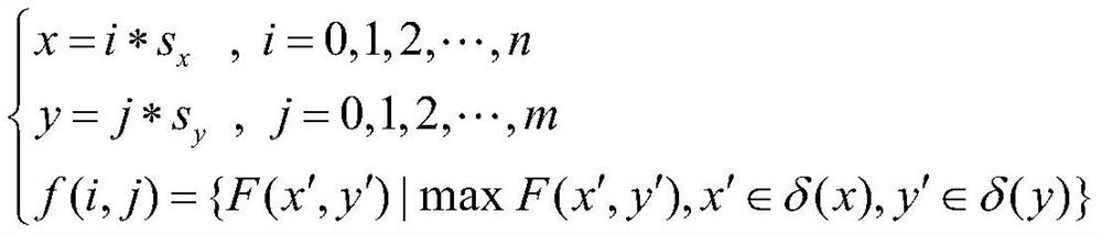
[0102] Step 2.1: Downsampling

[0103] Let the sampling ratio be s x ,s y , then t...


PUM


Abstract

The invention discloses a road lane line detection method based on line spacing feature point clustering in aerial photography video, comprising the following steps: reading video frames; image segmentation processing; extracting each lane line from a large number of data points in a balanced and sufficient manner feature points; construct a similarity matrix based on the similarity measurement method of line spacing, and cluster the feature points of different lane lines; establish a cubic B-spline model for lane lines, and use the improved RANSAC algorithm to estimate the parameters of the model; lane lines Parameter correction and forecasting. The invention preprocesses the detection and preprocessing of the highway edge in the aerial highway video, reduces the processing time of the next frame, effectively removes the interference pixels other than these highways, and has a better clustering effect on the lane line feature points , can get more accurate and stable lane line fitting effect, and can achieve real-time processing effect.

Description

technical field [0001] The invention belongs to the technical field of image processing and traffic video detection, and relates to a lane line detection method, which is mainly used in aerial highway video. Background technique [0002] In recent years, the UAV-based highway violation detection method has been widely proposed. Because the UAV is located at a high position, the monitoring range is wide, and the moving camera can track and detect more vehicle violations, it can control the highway more effectively. Vehicle violations on the road. At present, the detection of illegal behavior of vehicles on the road, such as illegal occupancy of emergency lanes and driving in violation of the prescribed lanes, is based on the accurate detection of lane lines and road edges. Man-machine detection of highway vehicle violations is of great significance. However, the existing detection methods are either not accurate enough, or the detection speed is low, which cannot meet the n...

Claims


Application Information

Patent Timeline
Patent Type & Authority Patents(China)
IPC IPC(8): G06K9/00G06K9/34G06K9/46G06K9/62
CPCG06V20/182G06V20/588G06V10/48G06V10/267G06V10/457G06F18/2163G06F18/23213
Inventor 路小波李永彬
Owner SOUTHEAST UNIV
Why Eureka
Try Eureka