A landslide susceptibility assessment method based on domestic GF-1 satellite data

A GF-1, satellite data technology, applied in the direction of electrical digital data processing, special data processing applications, instruments, etc.

Pending Publication Date: 2019-01-08
SICHUAN UNIVERSITY OF SCIENCE AND ENGINEERING
View PDF2 Cites 32 Cited by
  • Summary
  • Abstract
  • Description
  • Claims
  • Application Information

AI Technical Summary

Problems solved by technology

However, there are still some technical difficulties to be solved in landslide susceptibility assessment using GF-1 satellite data: First, in terms of landslide information remote sensing extraction, how to determine the image segmentation scale of GF-1 image in the area to be assessed, how to Construction of landslide information extraction rules, in order to quickly extract landslide information; secondly, in terms of evaluation factor screening, how to screen and determine the most relevant evaluation factors for landslides in the area to be evaluated; finally, in terms of landslide susceptibility evaluation model construction, How to choose the best model and parameters to realize landslide susceptibility probability calculation and grade zoning in the area to be evaluated

Method used


Image

  • A landslide susceptibility assessment method based on domestic GF-1 satellite data
  • A landslide susceptibility assessment method based on domestic GF-1 satellite data
  • A landslide susceptibility assessment method based on domestic GF-1 satellite data

Examples


Embodiment Construction

[0034] A specific embodiment of the present invention will be described in detail below in conjunction with the accompanying drawings, but it should be understood that the protection scope of the present invention is not limited by the specific embodiment.

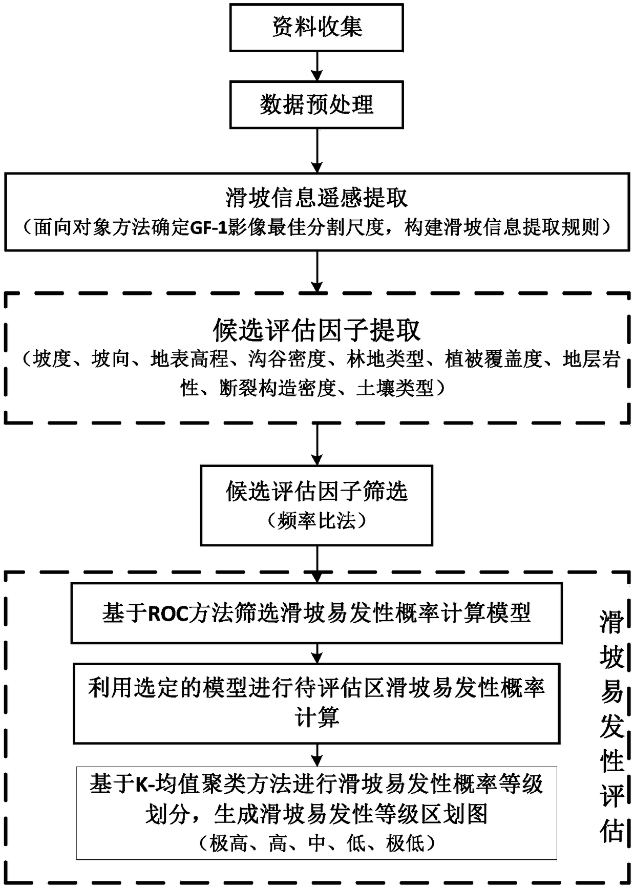
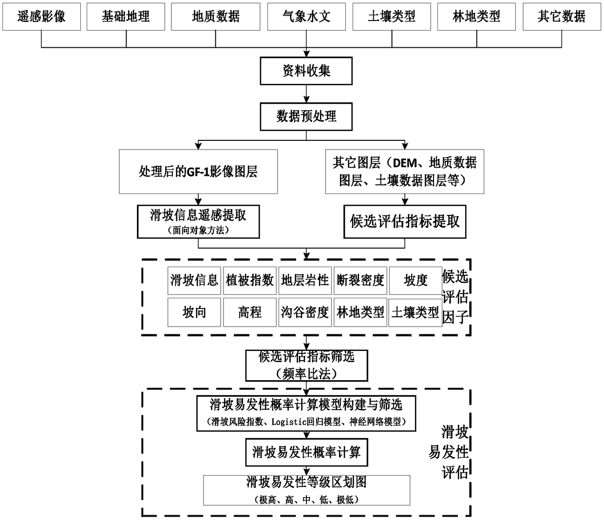
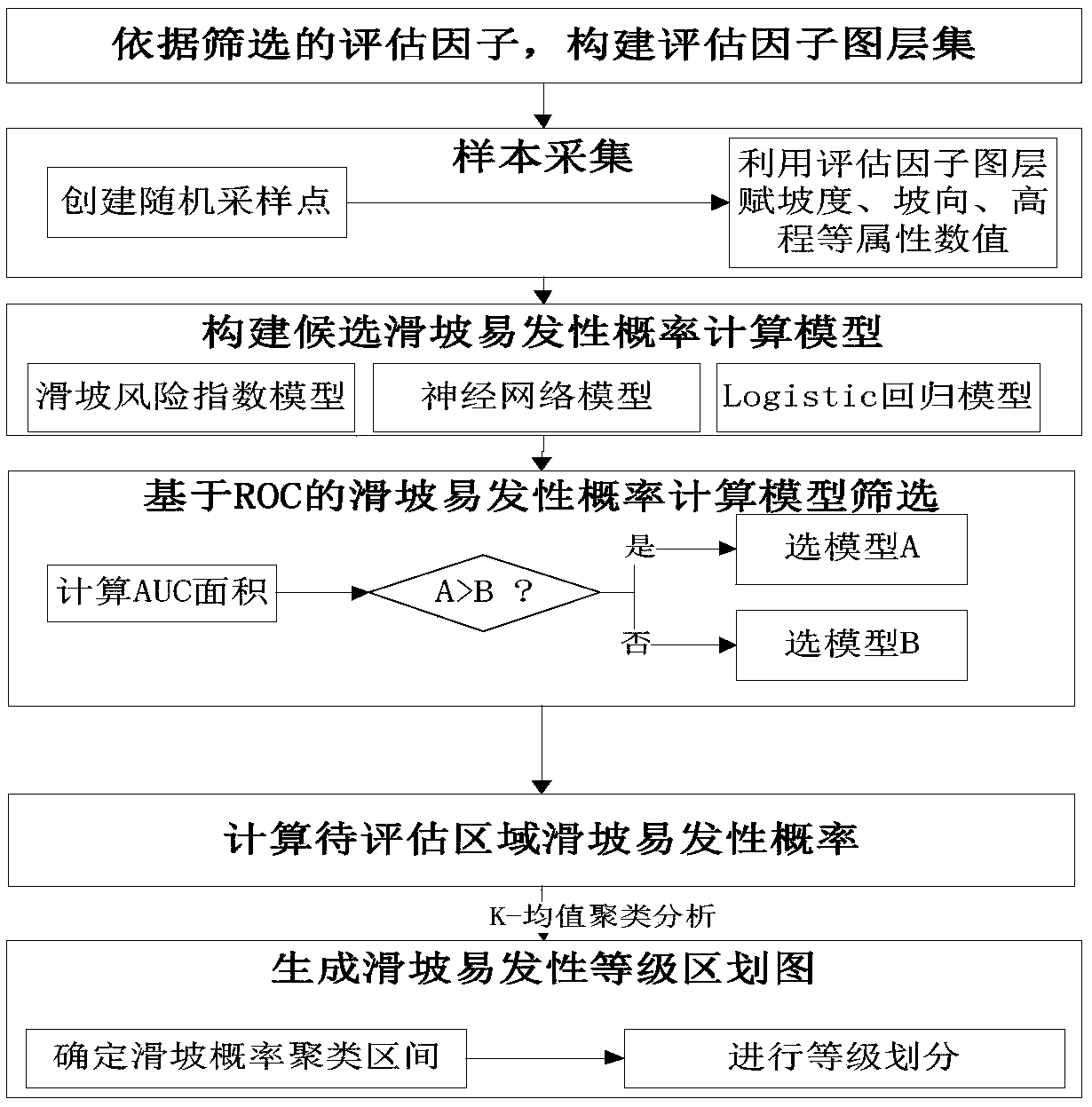
[0035] refer to figure 1 , figure 2 , image 3 Flow process, a specific implementation example of the present invention is as follows (data collection, data preprocessing part are no longer repeated here):

[0036] (1) Remote sensing extraction of landslide information based on domestic GF-1 data

[0037] 1) Determine the optimal segmentation scale and perform image segmentation: Select four GF-1 images in a certain area, preprocess them and splicing them into a whole piece of 2-meter multi-spectral image data that can cover the area to be evaluated, and carry out on the eCognition9.0 platform Multi-scale segmentation. Experimentally measured GF-1 satellite image data is the best segmentation scale when the segmentatio...


PUM


Abstract

The invention discloses a landslide susceptibility assessment method based on domestic GF-1 satellite data. The method comprises the following steps: (1) data collection; (2) data preprocessing; finally, the remote sensing data and other data are superposed and clipped to have uniform latitude and longitude range and grid element; (3) remote sensing extraction of landslide information; (4) candidate evaluation factors extraction and screening; (5) landslide susceptibility assessment. The method solves the problem of extracting landslide information by remote sensing, extraction and screening of landslide susceptibility assessment factors, construction of a landslide susceptibility assessment model, divides zones of landslide hazard susceptibility in the assessment area, provides basic datafor landslide hazard prediction and prediction, and is a scheme with high accuracy to assess landslide hazard susceptibility.

Description

technical field [0001] The invention relates to the field of geological disaster prevention and control, in particular to a landslide susceptibility evaluation method based on domestic GF-1 satellite data. Background technique [0002] Landslides are a natural phenomenon with great destructive power, blocking rivers, destroying roads, and even burying villages. Its destructiveness is second only to earthquakes, and it is also the most widespread and most harmful type of geological disaster. In recent years, with global warming, increased precipitation, the arrival of China's seismically active period and the impact of high and steep slopes caused by large-scale infrastructure construction, landslide disasters have become more frequent, and their impact on my country's economic development and social stability has become more and more serious. The greater it is, the more urgent it is to assess the susceptibility to landslide hazards. Landslide susceptibility assessment divide...

Claims


Application Information

Patent Timeline
Patent Type & Authority Applications(China)
IPC IPC(8): G06F17/50
CPCG06F30/20
Inventor 赵良军刘小芳
Owner SICHUAN UNIVERSITY OF SCIENCE AND ENGINEERING
Why Eureka
Try Eureka