


Quick Research
Generate reliable direction feasibility study reports for your R&D in just a few steps.

Technical Q&A
Discover and master advanced knowledge NOW. Basics, ideas, possibilities, all at once.

Find Solutions
As an expert in R&D theories, this can generate solutions to your technical problems instantly.

Evaluate Feasibility
Analyze your overall solution with one click, know your potential R&D risks in advance.

Monitor Landscape
Get weekly tech updates, stay abreast of the latest tech innovations and key insights.
Navigation estimation method and device, computer equipment and storage medium
A frame picture and path technology, applied in the navigation evaluation method, computer equipment and storage media, and device fields, can solve the problems that the accuracy of overspeed prompts needs to be improved, and achieve the effect of ensuring accuracy
- Summary
- Abstract
- Description
- Claims
- Application Information
AI Technical Summary
Problems solved by technology
Method used
Image

Examples
Embodiment 1
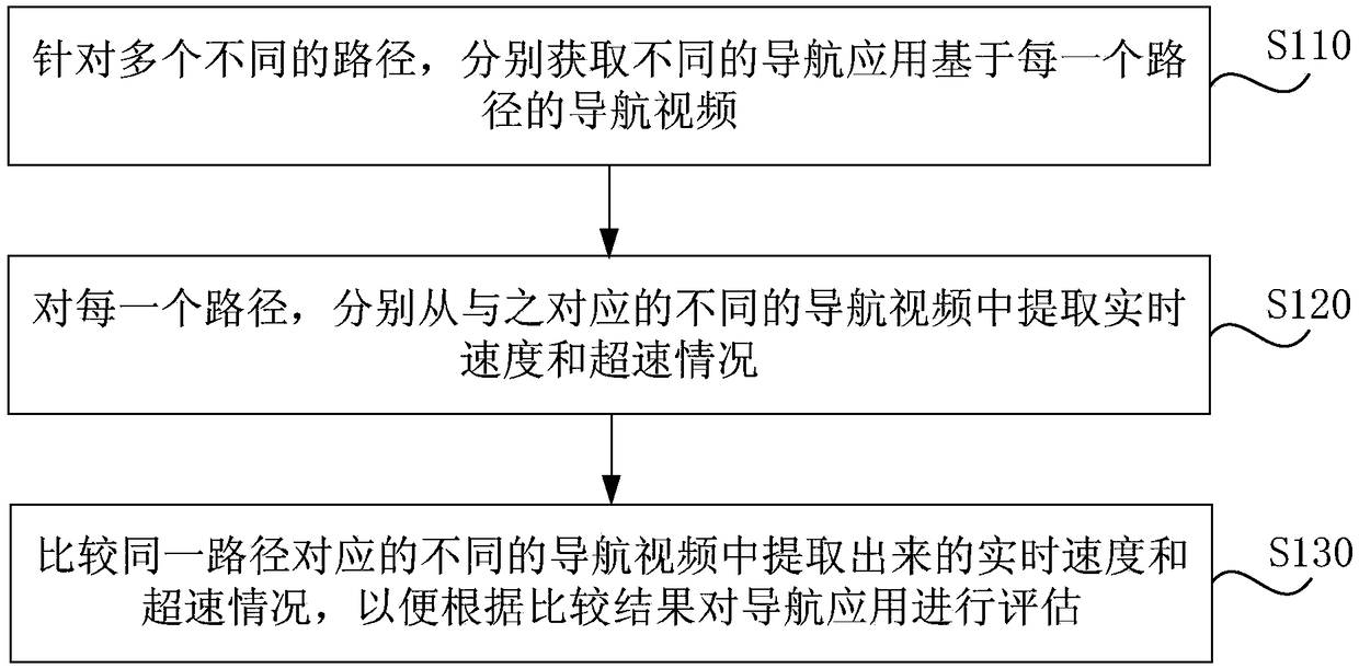
[0031] figure 1 It is a flow chart of the navigation evaluation method provided by Embodiment 1 of the present invention. This embodiment is applicable to the evaluation of navigation applications. The method can be executed by a navigation evaluation device, which can use software and / or hardware Realized, and can be integrated on computer equipment. Such as figure 1 As shown, the method may include:
[0032] S110. For multiple different paths, respectively acquire navigation videos based on each path by different navigation applications.
[0033] In this embodiment, the navigation video is a real navigation video for a specific route, and the current speed of the vehicle can be displayed in real time on the navigation screen. The navigation video can be obtained from the open navigation video library based on data statistics, or can be obtained by recording or simulating the navigation path in the real environment. Exemplarily, according to the starting point and end poi...
Embodiment 2
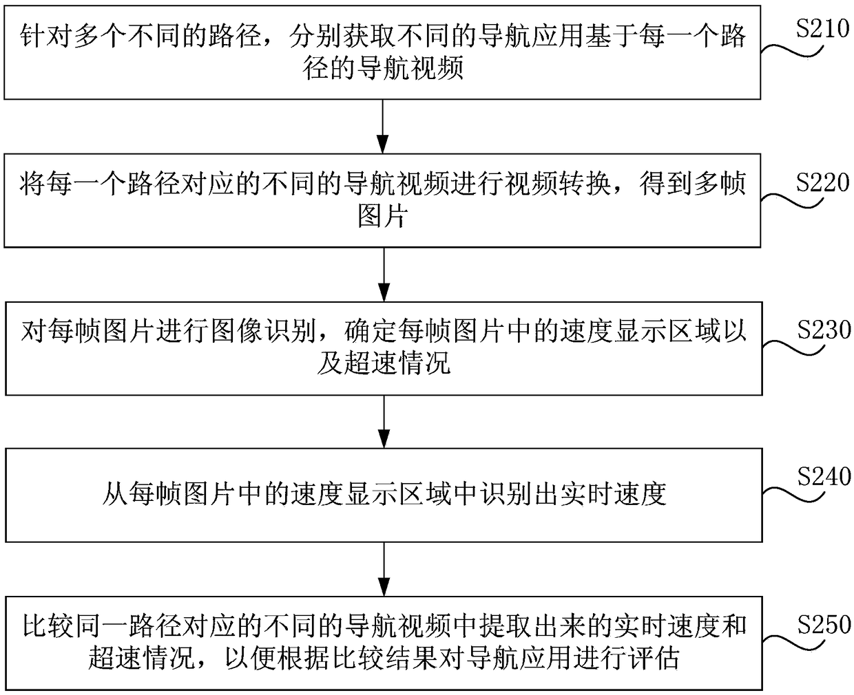
[0048] figure 2 It is a flow chart of the navigation evaluation method provided by Embodiment 2 of the present invention, and this embodiment is further optimized on the basis of the foregoing embodiments. Such as figure 2 As shown, the method may include:
[0049] S210. For multiple different paths, respectively acquire navigation videos of different navigation applications based on each path.
[0050] S220. Perform video conversion on different navigation videos corresponding to each path to obtain multiple frames of pictures.
[0051] Among them, after video conversion, a certain number of pictures can be extracted from the pictures included in each navigation video according to a preset time interval, such as 1 second, as pictures for subsequent identification of navigation data, and the number of pictures is not specified in this embodiment. limited. By converting navigation video into pictures, the difficulty of identifying navigation data can be reduced, thereby i...
Embodiment 3
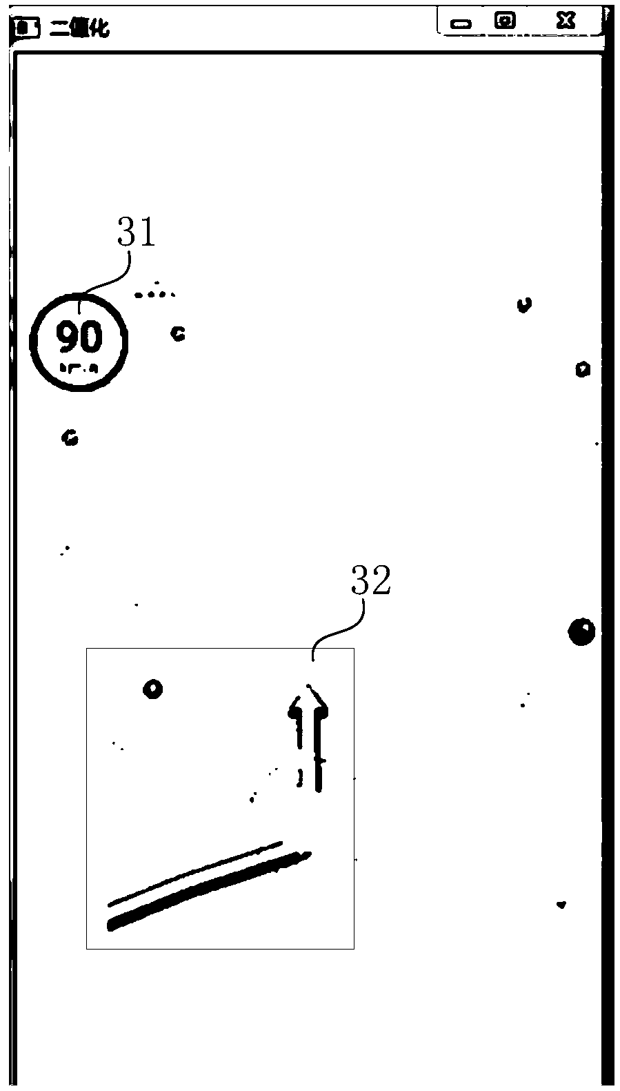
[0078] Figure 4 It is a flow chart of the navigation evaluation method provided by Embodiment 3 of the present invention, and this embodiment is further optimized on the basis of the foregoing embodiments. Such as Figure 4 As shown, the method may include:
[0079] S310. For multiple different paths, respectively acquire navigation videos of different navigation applications based on each path.
[0080] S320. Perform video conversion on different navigation videos corresponding to each path to obtain multiple frames of pictures.
[0081] S330. Perform image recognition on each frame of pictures, and determine the speed display area and the overspeed situation in each frame of pictures.
[0082] S340. Extract the Hough circle from the RGB color gamut map of each frame of pictures to obtain the Hough circle data in the RGB color gamut map of each frame of pictures, wherein the Hough circle data includes the position of the center of the Hough circle in each frame of picture...
PUM
 Abstract
Description
Claims
Application Information
 - R&D Engineer
- R&D Manager
- IP Professional
- Industry Leading Data Capabilities
- Powerful AI technology
- Patent DNA Extraction
Browse by: Latest US Patents, China's latest patents, Technical Efficacy Thesaurus, Application Domain, Technology Topic, Popular Technical Reports.
© 2024 PatSnap. All rights reserved.Legal|Privacy policy|Modern Slavery Act Transparency Statement|Sitemap|About US| Contact US: help@patsnap.com