Eureka AIR delivers breakthrough ideas for toughest innovation challenges, trusted by R&D personnel around the world.

Indoor positioning method and system based on PDR and geomagnetism

A positioning method and indoor positioning technology, applied in the field of indoor navigation, can solve the problems of affecting accuracy, prone to errors in Wi-Fi positioning, and limited scope of application of RFID positioning technology, and achieve the effect of improving accuracy

Inactive Publication Date: 2017-12-22
GUILIN UNIV OF ELECTRONIC TECH
View PDF8 Cites 33 Cited by
  • Summary
  • Abstract
  • Description
  • Claims
  • Application Information

AI Technical Summary

Problems solved by technology

[0003] Existing indoor positioning systems often need to collect a large amount of data in order to improve the geomagnetic matching accuracy, or need to combine external equipment to achieve auxiliary positioning, these conditions limit the application of indoor geomagnetic positioning
For example, if the Wi-Fi positioning calculation is only based on the currently connected Wi-Fi access point instead of referring to the signal strength composite map of the surrounding Wi-Fi, then Wi-Fi positioning is prone to errors, such as positioning the wrong floor, and , Wi-Fi access points usually only cover an area with a radius of about 90 meters, and are easily interfered by other signals, thereby affecting its accuracy, and the energy consumption of the locator is also high; since the light cannot pass through obstacles, Infrared rays can only spread in line of sight, and are easily interfered by other lights, and the transmission distance of infrared rays is short, making the effect of infrared technology IR indoor positioning poor; Bluetooth positioning is mainly used for small-scale positioning. For complex space environments, Bluetooth The stability of the positioning system is slightly poor, and it is greatly disturbed by noise signals; RFID positioning technology uses radio frequency to conduct non-contact two-way communication and exchange data to achieve the purpose of mobile device identification and positioning. It can obtain centimeter-level positioning accuracy within a few milliseconds information, and has a large transmission range and low cost; however, due to its disadvantages such as inconvenient integration into mobile devices and short working distance, the scope of application of RFID positioning technology is limited

Method used


Image

  • Indoor positioning method and system based on PDR and geomagnetism
  • Indoor positioning method and system based on PDR and geomagnetism
  • Indoor positioning method and system based on PDR and geomagnetism

Examples


Embodiment

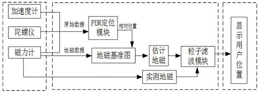
[0043] Such as figure 1 Shown, a kind of indoor positioning system based on PDR and geomagnetism, comprises the measurement module of serial connection, PDR positioning module, particle filter module and display module; Described measurement module further comprises accelerometer, gyroscope and magnetometer, accelerometer The gyroscope, gyroscope and magnetometer are respectively connected to the PDR positioning module, and the magnetometer is also connected to the particle filter module.

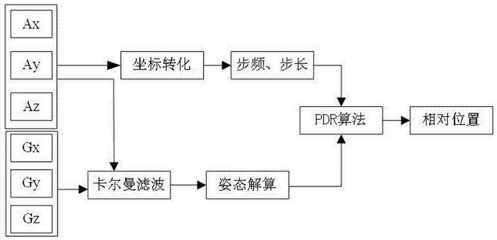
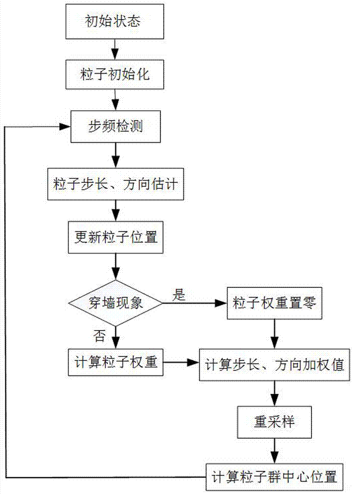
[0044] An indoor positioning method based on PDR and geomagnetism is based on the accelerometer, gyroscope and magnetometer inside the smart phone, using the magnetometer to obtain the geomagnetic data of the positioning area and using the Kriging interpolation algorithm to establish a global geomagnetic reference map; When the user is moving, use the accelerometer and gyroscope to obtain the user's step frequency, step length and direction angle information, so as to obtain the PDR positio...


PUM


Abstract

The invention discloses an indoor positioning method and system based on PDR and geomagnetism, the indoor positioning method is as follows: an accelerometer, a gyroscope and a magnetometer are arranged in an intelligent mobile phone, geomagnetic data of a positioning area can be obtained by the magnetometer, kriging interpolation algorithm is used to build a global geomagnetic reference map; when a user moves, the accelerometer and the gyroscope are used to obtain stride frequency, step length and direction angle information of the user to obtain PDR positioning results; and finally optimal positioning results of the user can be obtained by particle filter fusion algorithm, the positioning system includes a measuring module, a PDR positioning module, a particle filter module and a display module; the measuring module further comprises the accelerometer, the gyroscope and the magnetometer. The accelerometer, the gyroscope and the magnetometer are respectively connected with the PDR positioning module, and the magnetometer is also connected with the particle filter module. By combining of PDR and particle filter two positioning algorithms, the accuracy of the positioning results is improved, and indoor positioning can be achieved without the support of other external devices.

Description

technical field [0001] The invention relates to the technical field of indoor navigation, in particular to an indoor positioning method and system based on PDR and geomagnetism. Background technique [0002] Global Navigation Satellite System (GNSS) has become an indispensable main means of outdoor navigation and positioning for military, surveying and mapping, aviation, navigation, communication, electric power, transportation, meteorology, scientific research and personal navigation. GNSS is unavailable in cities, canyons and other occluded environments, complex electromagnetic environments with malicious interference, and indoor environments such as buildings, mines, tunnels, underground, and underwater. As the "last mile" of navigation and positioning, indoor positioning has always been a problem. How to effectively solve the worldwide problem has become the core issue of navigation and location services. At present, there have been a lot of researches on indoor positio...

Claims


Application Information

Patent Timeline
IPC IPC(8): G01C21/20G01C21/08
CPCG01C21/08G01C21/206
Inventor 蔡成林王亚娜甘才军李思民徐德昌
Owner GUILIN UNIV OF ELECTRONIC TECH
Why Eureka
Eureka Blog
Learn More