Observation system shot point optimization and design method based on three-dimensional terrain slope and orientation

An observation system and optimal design technology, applied in geophysical surveying, seismology, measuring devices, etc., can solve the problems of low signal-to-noise ratio, low imaging accuracy, and difficult resolution of seismic acquisition data, and achieve rapid optimal design Effect

Inactive Publication Date: 2017-11-10
CHINA PETROLEUM & CHEM CORP +1
View PDF3 Cites 7 Cited by
  • Summary
  • Abstract
  • Description
  • Claims
  • Application Information

AI Technical Summary

Problems solved by technology

In construction in these areas, the signal-to-noise ratio of seismic acquisition data is usually low, the imaging accuracy is low, and it is very difficult to improve the resolution; in the actual construction process, due to the relatively large terrain fluctuations, some steep mountains are often encountered, which poses a challenge People bring great difficulties, so it is necessary to find a collection and design method to improve the quality of data from the perspective of topography and landform

Method used


Image

  • Observation system shot point optimization and design method based on three-dimensional terrain slope and orientation

Examples


Embodiment Construction

[0028] Below in conjunction with accompanying drawing, the present invention is described in further detail:

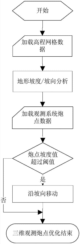
[0029] The invention provides a shot point optimization method of an observation system based on a three-dimensional terrain gradient and aspect, belonging to the field of seismic exploration and development. The method of the invention utilizes the three-dimensional terrain data of the work area to analyze the slope and aspect information of the position of the shot point, and reduces the difficulty of construction in complex areas by changing the position of the shot point, so as to achieve the rapid optimization design of the shot point of the observation system. The method comprises: (1) loading the elevation grid data of the work area; (2) analyzing the three-dimensional terrain slope and slope aspect information according to the elevation grid data of step (1); (3) loading the shot point data of the observation system, and setting the moving threshold; (4) Analy...


PUM


Abstract

The invention discloses an observation system shot point optimization and design method based on three-dimensional terrain slope and orientation, belonging to the seism exploration and development field. The observation system shot point optimization method uses three-dimensional terrain data of a work area to analyze the slope and orientation information of a position of a gun point, reduces construction difficulty through changing the shot point position and thus achieves fast shot point optimization design of the observation system. The observation system shot point optimization method based on the three-dimensional terrain slope and orientation comprises steps of (1) loading elevation grid data, (2) analyzing three-dimensional terrain slope and orientation information, (3) loading shot point data of the observation system and setting a mobile threshold value, (4) analyzing a slope value of the shot point position, performing optimization on the shot point which exceeds a threshold value rang and (5) calculating a difference of surface element covering times before and after the shot point optimization.

Description

technical field [0001] The invention belongs to the field of seismic exploration and development, and in particular relates to a shot point optimization design method of an observation system based on three-dimensional terrain slope and aspect. Background technique [0002] In recent years, 3D seismic field acquisition in China often encounters relatively complex topography and landform conditions, such as the eastern Sichuan region, where the terrain undulates violently and the surface conditions are relatively complex. In construction in these areas, the signal-to-noise ratio of seismic acquisition data is usually low, the imaging accuracy is low, and it is very difficult to improve the resolution; in the actual construction process, due to the relatively large terrain fluctuations, some steep mountains are often encountered, which poses a challenge Therefore, it is necessary to find a collection design method to improve the quality of data from the perspective of topograp...

Claims


Application Information

Patent Timeline
Patent Type & Authority Applications(China)
IPC IPC(8): G01V1/00G01V1/104
CPCG01V1/003G01V1/104
Inventor 王昀
Owner CHINA PETROLEUM & CHEM CORP
Why Eureka
Try Eureka