
Map-based advancing method and electronic map for implementation of map-based advancing method

An electronic map and map technology, applied in maps/plans/charts, electronic digital data processing, geographic information databases, etc., can solve problems such as out-of-field directions, difficult maps, inconvenience, etc., to deepen impressions and feelings, and distance measurement errors Reduced, efficient effect

Inactive Publication Date: 2017-09-26
中国人民解放军69080部队
View PDF2 Cites 0 Cited by
  • Summary
  • Abstract
  • Description
  • Claims
  • Application Information

AI Technical Summary

Problems solved by technology

The above steps are cumbersome, time-consuming, and have large errors
[0003] The step of calibrating the map. No matter how the user’s direction changes, the current electronic map will display the map in the fixed direction of the upper north, lower south, left west, and right east of the display screen, which is out of touch with the actual direction. and military operations personnel feel very inconvenient
Users sometimes get lost and can't find the north, especially in unfamiliar areas, it is even more difficult to use the map

Method used


Image

  • Map-based advancing method and electronic map for implementation of map-based advancing method

Examples


example 1

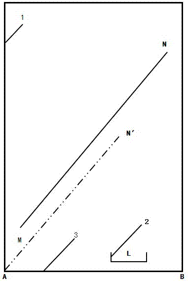
[0030] As shown in the accompanying drawings, it is intended to interpret the horizontal distance between points M and N on the map on the display screen 1 .

[0031] The first method: adopt the existing method before the present invention. As the screen zooms in and out, the length of the sign of the linear scale is almost unchanged, but the corresponding number of solid representations of the linear scale displayed on it changes accordingly. Map scales become larger and linear scales become more precise. But the scale logo will always appear tiny compared to the size of the screen. figure 1 Is a schematic diagram, in fact the size of the linear scale is much smaller. Therefore, the straight-length route of MN on the electronic map can only be compared with the length of the straight-line scale. Not only is it time-consuming and troublesome, it hurts the eyes to look at it, and more than 3 minutes can only be estimated by visual inspection. Moreover, 6 people participated...

example 2

[0037] The comparison between the traditional map marking method and the method of the present invention is as follows:

[0038] On-site calibration of the map orientation is to make the upper north, lower south, left west, and right east orientations of the map consistent with the actual orientation. In January 2015, the second edition of "Military Topography and Orienteering" edited by Hu Yunda published by Wuhan University Press introduced four traditional map calibration methods. The first method is rough calibration. This method is simple and quick, but the location must already be known. This is difficult to do in unfamiliar terrain without a compass, especially at night when the constellations cannot be seen clearly and there are no natural features. The second method is compass calibration, but it cannot be realized without a compass. The third method is to use straight and long ground objects to calibrate. It is difficult to find such conditions in the Gobi desert...


PUM


Abstract

The invention relates to a map-based advancing method and an electronic map for implementation of the map-based advancing method. According to the method, map zooming and translation are performed before distance estimation to make the distance on a map is approximately uniform with length or width of the map, and the length or width marked on a screen can be read directly; map calibration is automatically completed by systems of the electronic map, Beidou and the like, and no matter which direction and position the display screen has, the north, south, west and east directions of the electronic map always accord with real orientations. By the map-based advancing method and the electronic map, the problem that a user is prone to confusing about directions due to difficulty in north determination on site, especially map-based advancing in unfamiliar regions is solved; the prejudice of people sticking to scale sketch maps for years is changed, and high judgment and reading efficiency is achieved; by map zooming and translation with hands, the user can have fun in the sense of mastery; by automatic map calibration, impression and feelings of the user about in-situ landform are deepened.

Description

technical field [0001] The invention relates to a method for traveling according to a map and an electronic map for realizing the method. The method includes selecting a route on the map, estimating distance, and marking a map; the electronic map for realizing the method includes geographic elements, mathematical elements, and auxiliary elements. Background technique [0002] In January 2015, the second edition of "Military Topography and Orienteering" edited by Hu Yunda, published by Wuhan University Press, introduced the method of traveling according to the map, including the following steps: select the route on the map, estimate the distance, and calibrate the map. When estimating the distance, generally use the range meter roller to walk on the map first, and then read the odometer. However, due to the uncertain scale of the electronic map and the smooth and fragile screen, it cannot be implemented in practice. When the map is zoomed, the tiny scale map on the screen zo...

Claims


Application Information

Patent Timeline
Patent Type & Authority Applications(China)
IPC IPC(8): G06F17/30G09B29/00
CPCG06F16/29G09B29/005
Inventor 徐云林文禄曹旭峰
Owner 中国人民解放军69080部队
Learn More